


Today’s Forecast:
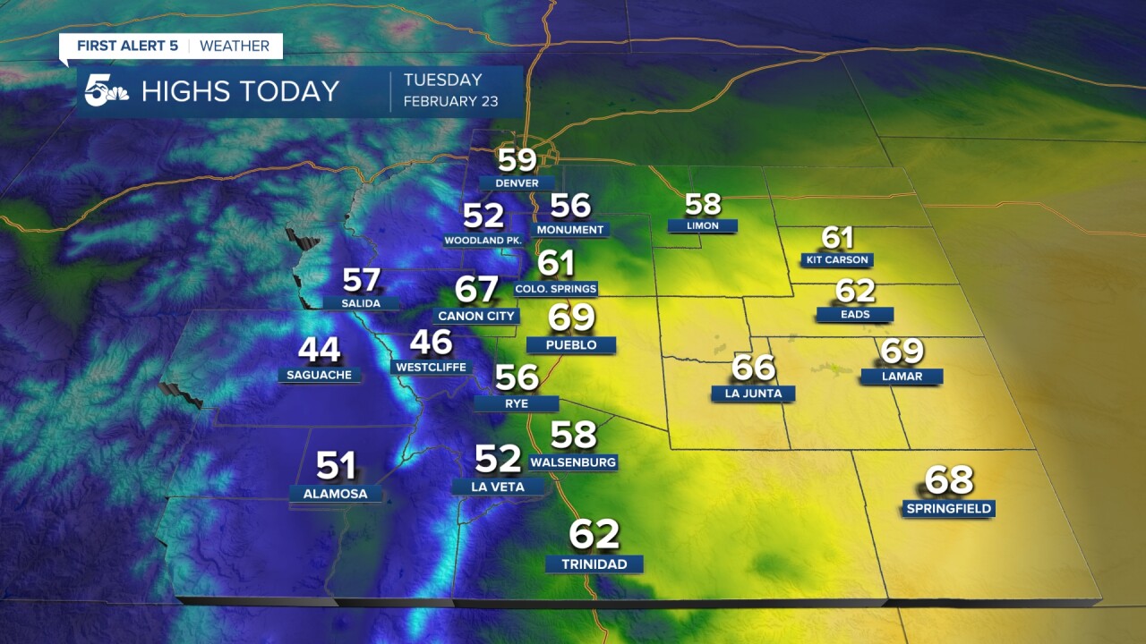
Stunning forecast today with sunny skies and gusty northwest winds through the region. We'll see highs in the 60s across the plains, and even through mountains won't feel too bad!
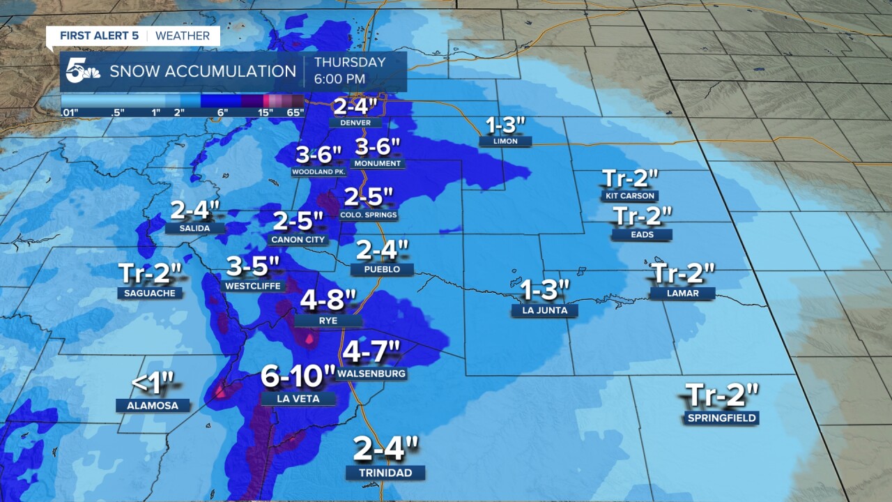
High Impact Winter Event Possible:

We could see a high-impact event Wednesday and Thursday from freezing drizzle and heavy snow.
Freezing drizzle is possible early Wednesday morning in El Paso, eastern Fremont, western Pueblo, and Huerfano counties. This could put a thin layer of ice on the roads and cause multiple accidents for unaware drivers. Freezing fog is more likely, but it doesn't take much to push the fog into drizzle.
Heavy snow is expected Wednesday night through Thursday morning. On the low end this is a 2 inch snow for the I-25 corridor, but on the high end it's a 4 to 5 inch snow. Thursday morning commutes look very dangerous from heavy snow and any lingering ice from Wednesday morning.
COLORADO SPRINGS: High: 61; Low: 21. Sunny, warm, and breezy today with dry skies. A cold front tonight will push lows below freezing and we have the ability for freezing fog, or more importantly, freezing drizzle Wednesday morning. If we do develop freezing drizzle tomorrow morning, it could lead to a thin layer of ice on the roads.
PUEBLO: High: 69; Low: 23. Sunny, windy at times, and really warm today! We'll see a cold front overnight push lows into the 20s but we probably just see fog if anything Wednesday morning.
CANON CITY: High: 67; Low: 24. Sunny and windy today with warm temperatures. We have a chance for freezing fog and even freezing drizzle Wednesday morning, which could challenge the commutes on highway 50.
WOODLAND PARK: High: 52; Low: 17. Sunny and windy with mild high temperatures. We won't see any fog this evening but we will get pretty cold.
TRI-LAKES: High: 50s; Low: 10s. Sunny, windy, and warm today with dry skies. Overnight there could be patchy fog in the area but freezing drizzle is not expected at this time.
PLAINS: High: 60s; Low: 20s. Sunny, breezy, and very warm today. Overnight there could be areas of fog develop, and if we do see freezing drizzle it'll be closer to I-25 in El Paso and Huerfano counties.
WALSENBURG/TRINIDAD: High: 50s; Low: 20s. Warm and windy with lots of sunshine today. We'll get a cold front tonight to push areas of fog, and possibly freezing drizzle into the Walsenburg area Wednesday morning. If freezing drizzle does form, it could lead to a thin layer of ice on the roadways.
MOUNTAINS: High: 50s; Low: 20s. We'll stay dry over the mountains today but clouds will build through the afternoon and we'll be windy through the daytime. Gusts could be as high as 30 to 40 mph in a few spots.
Extended Outlook:
As talked about above, freezing fog and drizzle is a concern for Wednesday morning, mostly the freezing drizzle. We'll see heavy snow push into the region Wednesday night through early Thursday morning.
We should be dry from Friday through the weekend.
KOAA News5 on your time, streaming on your Roku, FireTV, AppleTV and AndroidTV.
News5 App | First Alert 5 Weather App | Youtube | Facebook | Instagram | Twitter
