


Today’s Forecast:
Really tough forecast this week with cloudy, cool, and wet weather returning to southern Colorado.
Today should be dry across the region with high fire danger in the San Luis Valley and gusty conditions through the plains. We'll stay chilly today with highs in the 50s across the lower plains. Overnight snow showers will push across the region, but mostly in northern Fremont County and areas north through Teller and western El Paso county.
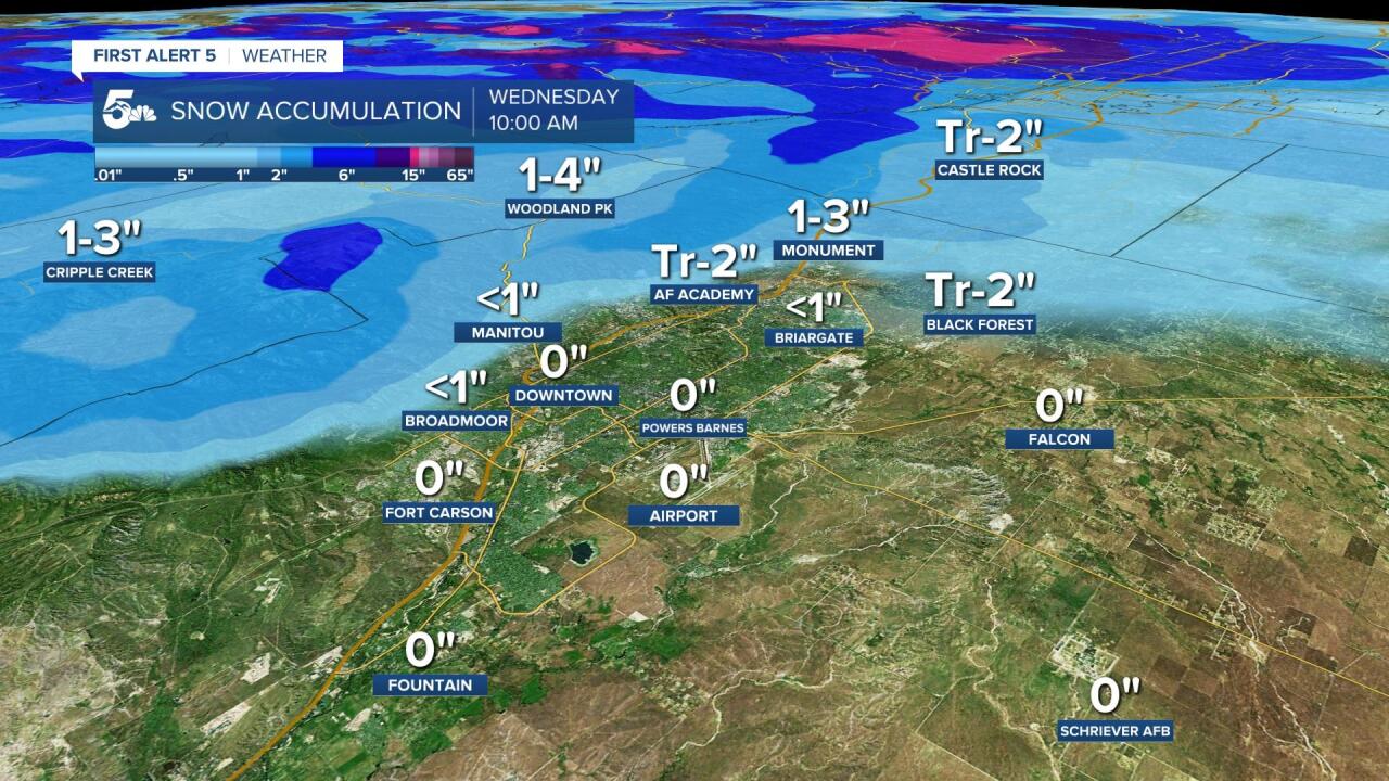
COLORADO SPRINGS: High: 50; Low: 28. Gusty and chilly today with a mix of sun and cloud cover through the afternoon. Light snow showers to flurries are possible late tonight through Tuesday morning, but very little accumulation is expected. What snow we do see tonight will be mainly on the far north or west sides of town. More snow will fall Tuesday night through Wednesday morning, and that could drop an inch or two on the north and west sides of town.
PUEBLO: High: 57; Low: 33. Dry and windy today with mild afternoon temperatures in the sunshine.
CANON CITY: High: 52; Low: 35. Gusty and chilly today with dry skies today and tonight. Any snow tonight will occur west in the valley or north over the mountains.
WOODLAND PARK: High: 41; Low: 23. Increasing clouds with chilly daytime temperatures and breezy afternoon conditions. We will see snow showers move in late tonight with around an inch of accumulation possible in grassy areas by Tuesday morning. More snow will fall Tuesday night through Wednesday morning, and another 2 to 3 inches will be possible.
TRI-LAKES: High: 40s; Low: 20s. Partly cloudy, windy at times, and dry today with light snow showers developing overnight and lasting into early Wednesday morning. Little snow accumulation is expected, and what does collect will mostly be in the grass. More snow is expected Tuesday night through Wednesday morning, and that's where we'll see most of our accumulation.
PLAINS: High: 50s; Low: 30s. Gusty, dry, and sunny through the plains with dry skies and cool daytime temperatures.
WALSENBURG/TRINIDAD: High: 50s; Low: 30s. Windy but dry through Walsenburg and Trinidad with chilly afternoon temperatures.
MOUNTAINS: High: 40s; Low: 20s. Dry and windy today with snow developing over the mountains late tonight through Tuesday morning. The heavier and better accumulating snow is expected Tuesday afternoon through Wednesday morning.
Extended Outlook:
We'll see our main wave of snow Tuesday night through Wednesday morning, and the bulk of our accumulation will be over the mountains and the higher elevation spots of the Pikes Peak region.
We'll see more scattered showers Wednesday afternoon, and then the second push of rain to snow Thursday afternoon and overnight. We'll keep rain to snow chances in the forecast from Friday through Saturday.
KOAA News5 on your time, streaming on your Roku, FireTV, AppleTV and AndroidTV.
News5 App | First Alert 5 Weather App | Youtube | Facebook | Instagram | Twitter
