



Today’s Forecast:
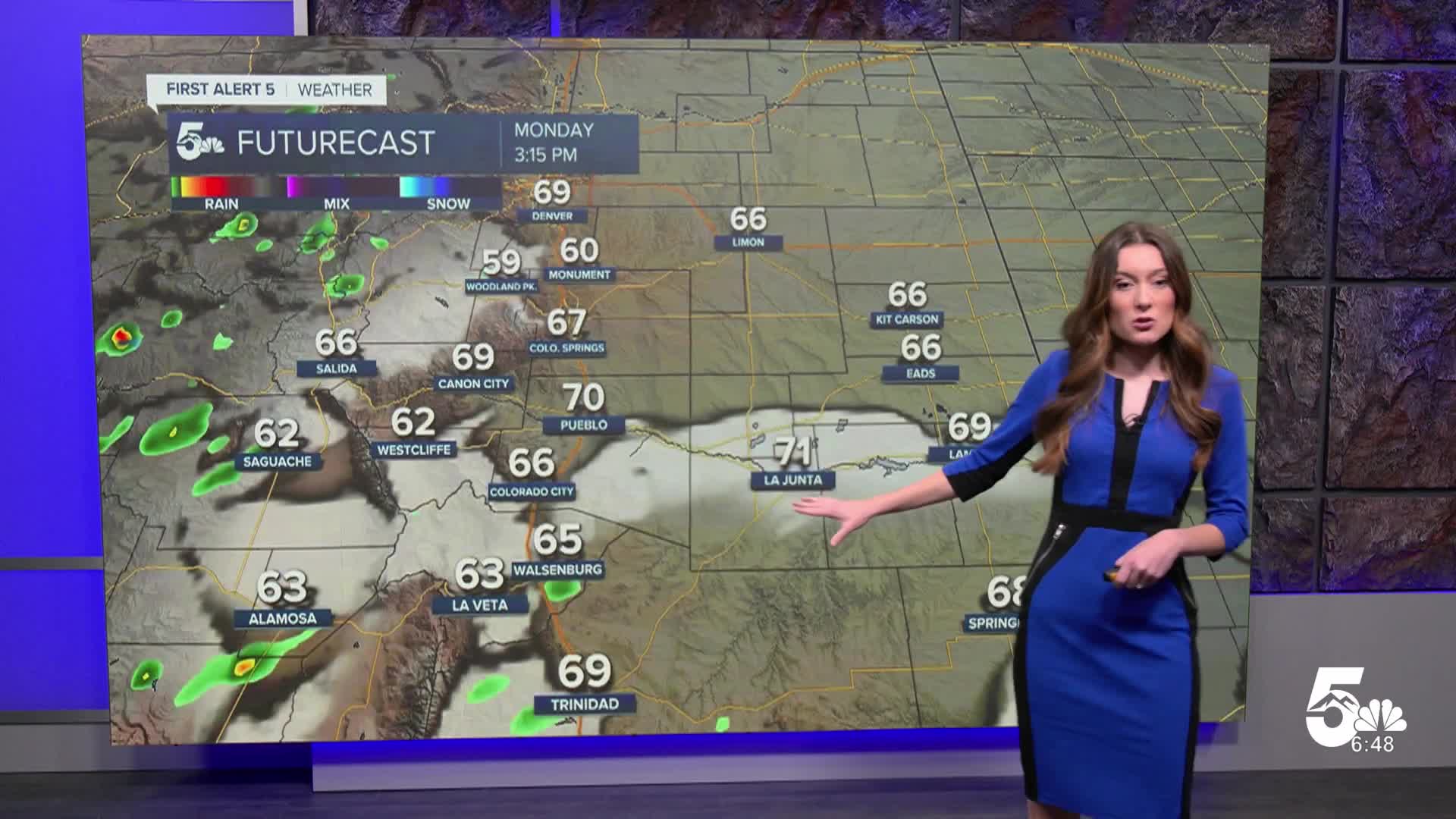
We will drop a few more degrees this morning before temperatures start to rise. Lows this morning will be in the 40s and 50s. Highs will still be above average. By that time, temperatures will be in the 60s and 70s. A high-pressure system will keep things calm and clear through Wednesday.
Colorado Springs forecast: High: 67 ; Low: 42.
Colorado Springs will have temperatures this morning in the lower 50s. Temperatures may briefly cool into the upper 40s, but will quickly rise as the sun comes up. Afternoon temperatures will be on the warm side eventually getting into the upper 60s. Winds will be coming out of the southwest between 5-10mph.
Pueblo forecast: High: 70; Low: 43.
Pueblo will have temperatures this morning in the lower 50s. Once the sun rises, temperatures will warm quickly. Afternoon highs will reach the lower 70s. There will be a few more clouds in the afternoon as a shortwave moves through the higher terrain. Rain chances will stay towards the mountains. Winds will also be calm.
Canon City forecast: High: 69; Low: 45.
Canon City will wake up to temperatures this morning in the 40s and 50s. Conditions are nice and clear, and afternoon temperatures will rise into the upper 60s. There will be a few areas in Fremont county that reach the lower 70s. A few more clouds are possible in the afternoon as isolated showers move through the mountains.
Woodland Park forecast: High: 60; Low: 37.
Woodland Park will start the day in the 30s. There will also be mostly clear conditions. With plenty of sunshine, afternoon highs will reach the lower 60s today. A small disturbance will move through the mountains today. A stray shower is possible, but the majority of the activity will stay towards the Continental Divide. Morning lows will be cooler on Tuesday.
Tri-Lakes forecast: High: 60s; Low: 40.
Monument and the surrounding areas will have temperatures in the 40s this morning. The day will start with plenty of sunshine and there will be a few more clouds in the afternoon. Temperatures will reach the 60s. Winds will be light between 5-10mph.
Plains forecast: High: 60s & 70s; Low: 40s.
The eastern plains are starting the day off with some mid-to-upper level clouds. Temperatures this morning are in the 40s and 50s. By the afternoon, these temperatures will be in the 60s and 70s. Winds will be light between 5-15mph.
Walsenburg and Trinidad forecast: High: 65/69; Low: 46.
The southern portion of I-25 will start the day with temperatures in the 40s. Once the sun rises, temperatures will too. By the afternoon, highs will have reached the mid-to-upper 60s. A stray shower or two is possible in the afternoon.
Mountains forecast: High: 60s; Low: 30s.
The mountains will have temperatures this morning in the 30s. A few areas closer to Westcliffe are below freezing. Afternoon highs will eventually reach the 60s. Winds may briefly increase as showers pass through. Most of the showers will be towards the Continental Divide.
Extended outlook forecast:
The next few days will continue to stay nice. This high-pressure system over the region will keep things calm through Wednesday. An incoming low-pressure system will bring some southwesterly flow over Colorado. Moisture will also be dragged into the state. The southwestern mountains will be the target of this moisture will some areas getting close to 2" of rainfall. The mountains will block this moisture from reaching I-25. Shower chances will remain isolated around 20-30% on Thursday.
____
Curious about the First Alert 5 Weather Storm Impact Scale? Check out our cheatsheet explainer.
Watch KOAA News5 on your time, anytime with our free streaming app available for your Roku, FireTV, AppleTV and Android TV. Just search KOAA News5, download and start watching.
