

Tonight's Forecast:
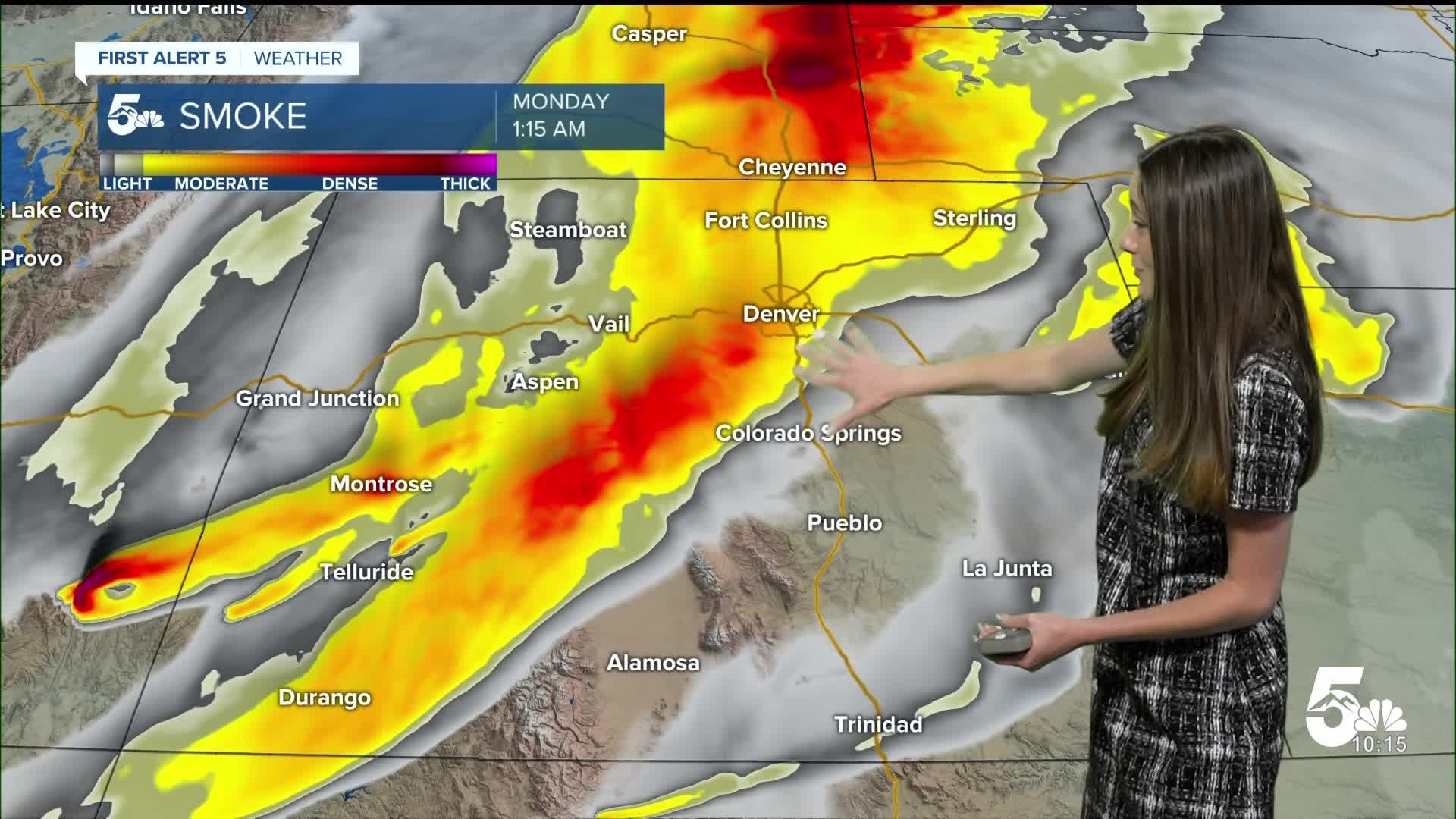
Tonight, we will have more smoke and haze move into the area. That boundary layer overnight will cause some of that smoke to become a little more prevalent in our area. Overnight lows will dip into the 50s and 60s. By tomorrow morning, hazy conditions linger and will slowly ease during the day.
Tomorrow's Forecast:
If you are sensitive to the smoke, be sure not to spend too much time outside tomorrow, especially in the morning. The smoke does look to lighten during the day, but it won't completely go away. Areas further west and north are under an air quality alert for wildfire smoke. Temperatures will continue to be hot, reaching the 90s and 100s. Closer to the mountains, highs will reach the 80s. Red flag warnings will expand along the I-25 corridor, so be cautious to not start any fires.
Colorado Springs forecast: Low: 60; High: 90;
Colorado Springs will have temperatures in the 60s in the morning. Conditions will warm quickly and by the afternoon these temperatures will reach highs in the lower 90s. El Paso county will be included in the red flag warning until 10PM.
Pueblo forecast: Low: 64; High: 97;
Pueblo will have a little bit of haze in the morning, and temperatures will be in the mid-60s. These temperatures will warm quickly as the sun rises. By the afternoon, highs will reach the upper 90s. Pueblo county will be included in another red flag warning from 10AM until 10PM.
Canon City forecast: Low: 64; High: 93;
Canon City will also wake up to some smoke and haze tomorrow morning. There may be some additional smoke in some areas due to a fire burning in northern Fremont county. Afternoon highs will be getting into the lower 90s.
Woodland Park forecast: Low: 54; High: 80;
Woodland Park will have morning temperatures in the mid-50s. Expect the smoky conditions to continue tomorrow. The worst conditions will be in the early morning hours and later in the evening. Afternoon highs are still expected to be on the warmer side with highs getting into the 80s.
Tri-Lakes forecast: Low: 56; High: 83;
The Monument area will have morning temperatures in the mid-50s. There will be some stronger wind gusts tomorrow, and combined with dry conditions, El Paso county will be placed in a red flag warning from 10AM until 10PM. Afternoon temperatures will be in the lower 80s.
Plains forecast: Low: 60s & 70s; High: 90s & 100s;
The eastern plains will have temperatures tomorrow morning in the 60s and 70s. There will be more smoke tomorrow. Hot conditions return to the area with highs reaching the 90s and 100s.
Walsenburg and Trinidad forecast: Low: 66/65; High: 91/96;
The southern I-25 corridor will wake up to temperatures in the mid-60s. Red flag warnings will be in place starting at 10AM and lasting until 10PM. Afternoon highs will be in the 90s.
Mountains forecast: Low: 50s; High: 80s;
The mountains will continue to see the smoky skies tomorrow. Highs will be above average getting into the 80s. Winds will be strong at times and will start to pick up by mid-morning.
Extended outlook forecast:
The smoke will likely continue over the next few days. It depends on how quickly these fires are knocked down. You also need to expect these hot conditions to continue. Towards the end of the week a high pressure system will build and temperatures will heat up. The fourth of July looks quite toasty with some areas getting into the 100s.
____
Curious about the First Alert 5 Weather Storm Impact Scale? Check out our cheatsheet explainer.
Watch KOAA News5 on your time, anytime with our free streaming app available for your Roku, FireTV, AppleTV and Android TV. Just search KOAA News5, download and start watching.
