



Today’s Forecast:
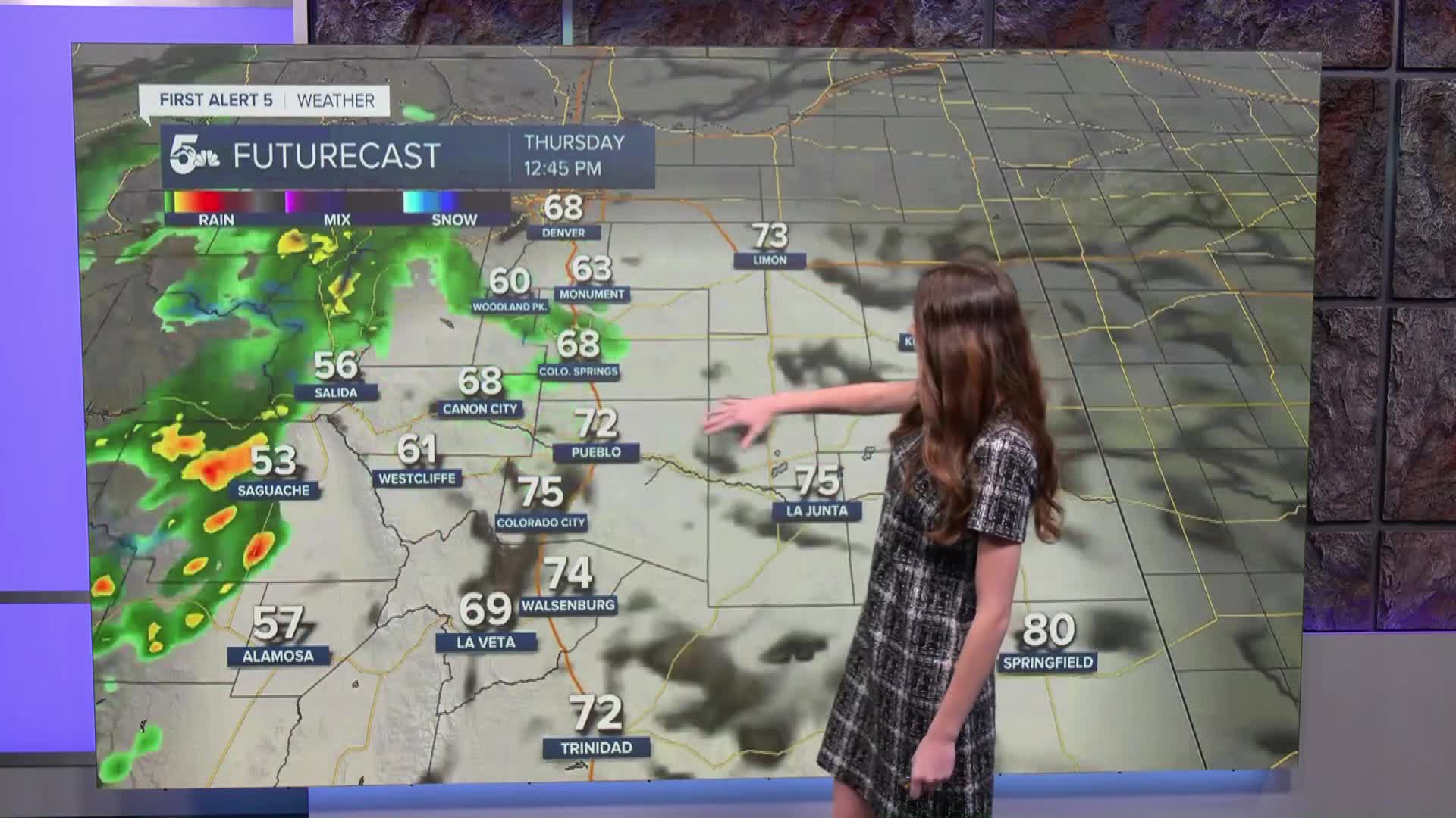
This morning temperatures are warmer sitting into the 50s and 60s. That moisture has finally arrived to Colorado and widespread rain is impacting the mountains. For I-25, isolated rain chances will last throughout the day. There is a possibility of some thunderstorm activity further south across Pueblo county this afternoon. Highs will still be warm despite the cloud cover.
Colorado Springs forecast: High: 72; Low: 50.
Colorado Springs is sitting in the 50s this morning. These warm temperatures will last into the afternoon and highs will reach the lower 70s. Isolated rain chances are possible later on this afternoon. These warm temperatures will last into Friday before a cold front moves in and drops temperatures over the weekend.
Pueblo forecast: High: 77; Low: 53.
Pueblo is waking up to temperatures in the lower 60s this morning. Even though temperatures are warmer, a rain jacket or umbrella is not a bad idea to grab as you are headed out the door. Rain will move into parts of Pueblo county this morning and chances will remain through the afternoon. Highs will reach the upper 70s.
Canon City forecast: High: 73; Low: 53.
Canon City will have temperatures this morning in the upper 50s. There is some rain moving into parts of Fremont county this morning, and these rain chances will last into the afternoon. Highs will reach the lower 70s.
Woodland Park forecast: High: 63; Low: 48.
Woodland Park will start the day with temperatures in the 40s. A few isolated showers will move east into Teller county throughout the day. Despite the increased clouds and rainfall, temperatures will still make it into the lower 60s.
Tri-Lakes forecast: High: 67; Low: 51.
Monument is steering clear of showers this morning, but these chances are still possible this afternoon. Temperatures this morning are sitting in the 50s. Highs will reach the upper 60s later on today. This evening those temperatures will dip into the lower 50s.
Plains forecast: High: 80s; Low: 50s.
With this ridge in place, conditions will stay warm across the plains. Afternoon highs will reach the 80s. A few stray showers are possible today. Once we get into the evening, temperatures will drop into the 50s. Cooler temperatures won't arrive until the weekend.
Walsenburg and Trinidad forecast: High: 74/76; Low: 53.
The southern portion of I-25 has some rain moving in from the west. I-25 may have some wet spots, and rain is expected to continue this afternoon. Highs will still be warm getting into the mid-70s by the afternoon. Cooler temperatures will eventually move in by the weekend.
Mountains forecast: High: 60s; Low: 40s.
The mountains will get the bulk of the moisture over the next several days. Flood watches are in place through Friday at noon. Rainfall totals between 2-4 inches are possible. Afternoon highs will reach the 60s today.
Extended outlook forecast:
Looking ahead, temperatures will remain warm. Friday will likely be the warmest day of the week before temperatures take quite the dip. A cold front will move in late Friday and early Saturday morning. Along with the cooler temperatures, moisture moves back in which means more rain for portions of I-25. These cooler temperatures will stick around throughout the weekend and into the beginning of next week.
____
Curious about the First Alert 5 Weather Storm Impact Scale? Check out our cheatsheet explainer.
Watch KOAA News5 on your time, anytime with our free streaming app available for your Roku, FireTV, AppleTV and Android TV. Just search KOAA News5, download and start watching.
