

Tonight's Forecast:
Thunderstorm chances will be possible through 8PM. Rain will begin to calm down overnight and skies will start to clear out. Monday's temperatures will be much warmer and a high pressure system will limit thunderstorms.
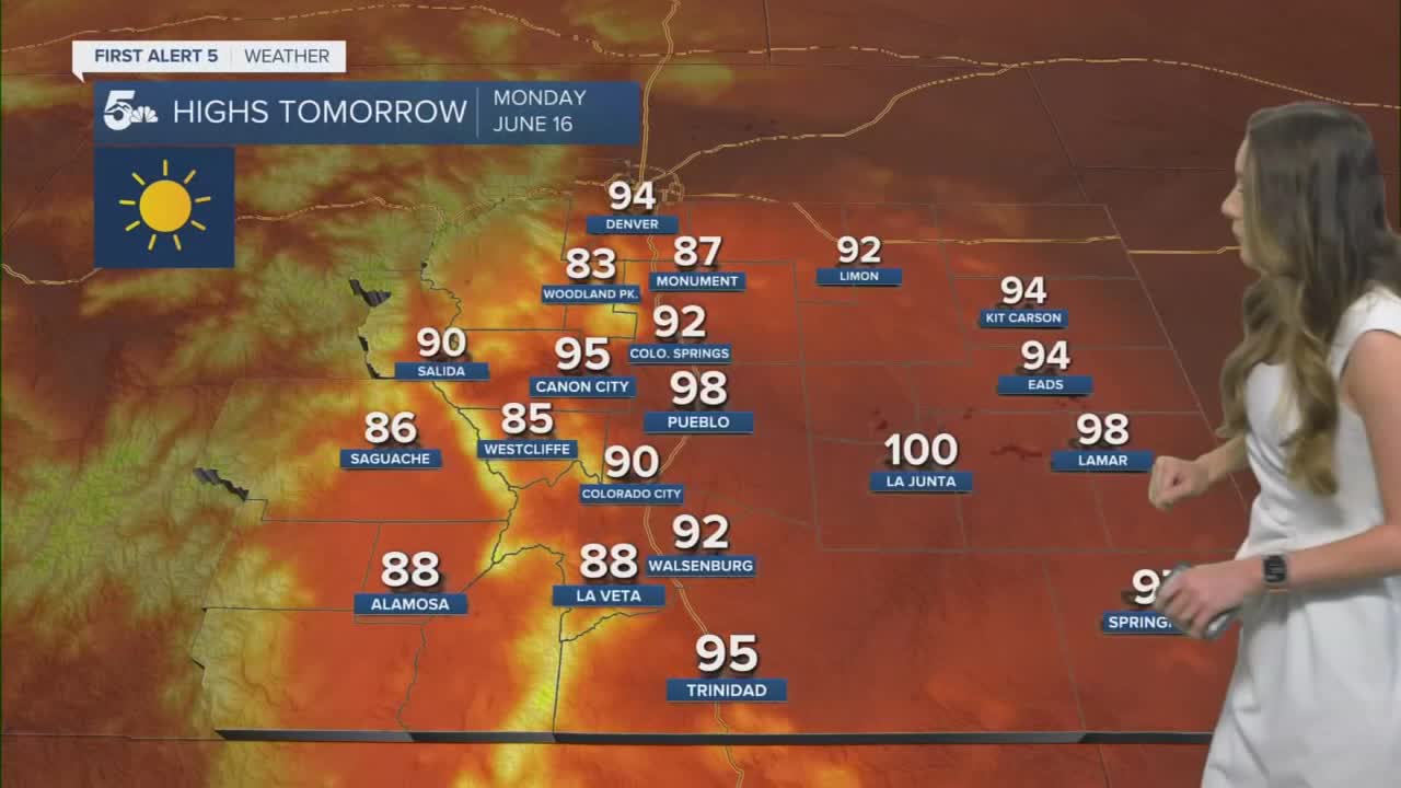
Colorado Springs forecast: High: 92; Low: 56;
Temperatures tonight will drop into the mid-50s and rain chances will continue shortly after 7PM. Highs on Monday will be much warmer and the Springs area will likely see temperatures in the 90s. No thunderstorms are expected.
Pueblo forecast: High: 98; Low: 59;
Pueblo will drop into the upper-50s which is a few degrees above average. This trend will continue into Monday with highs approaching the upper 90s. Temperatures will cool down slightly on Tuesday.
Canon City forecast: High: 95; Low: 59;
Canon City will start to clear out tonight and temperatures will be comfortable in the upper 50s. Monday, highs will be in the mid-90s and winds will be light.
Woodland Park forecast: High: 83; Low: 51;
Woodland Park will have rain chances through 7PM and clouds will continue to clear overnight. No severe risk is expected overnight and temperatures will drop into the lower 50s. Tomorrow, temperatures will get into the lower 80s. No thunderstorms are expected, and winds will stay light.
Tri-Lakes forecast: High: 87; Low: 55;
The Monument area will have overnight lows in the mid-50s and winds will stay light. There will be a few thunderstorms until 8 or 9PM. Skies will clear overnight and make way for sunny skies tomorrow. Temperatures will rise into the upper 80s.
Plains forecast: High: 90s & 100s; Low: 60s;
The plains will have another hot day with highs tomorrow in the 90s and potentially triple digits along the Arkansas River. Overnight lows tonight will drop into the 60s across the area.
Walsenburg and Trinidad forecast: High: 92/95; Low: 56;
The southern I-25 corridor will have temperatures in the mid-50s tonight and thunderstorms will continue to exit the area. Sunny skies tomorrow will heat things up with temperatures rising into the lower 90s.
Mountains forecast: High: 80s; Low: 40s;
The mountains will have overnight temperatures in the 40s and with the higher elevation temperatures will only make it into the 70s and 80s. Thunderstorm activity will be very limited, and the majority of the day will have clear conditions.
Extended outlook forecast:
Tuesday will have a cold front swing through which will increase the chance for thunderstorms again. Some storms could be severe. This will also drop temperatures closer to the seasonal average through Wednesday. Thursday, the sunshine will return and bring temperatures back to above average.
____
Curious about the First Alert 5 Weather Storm Impact Scale? Check out our cheatsheet explainer.
Watch KOAA News5 on your time, anytime with our free streaming app available for your Roku, FireTV, AppleTV and Android TV. Just search KOAA News5, download and start watching.
