

Tonight's Forecast:
Temperatures tonight will take quite a drop, eventually getting into the 30s for the morning lows. There will be some areas in the higher terrain that reach the upper 20s. It's a good time to start preparing any outdoor pipes and bringing in any potted plants.
Tomorrow's Forecast:
Temperatures will be very similar to today with 60s and 70s across the I-25 corridor. Sunny conditions will help with that. There will be a noticeable increase in our wind gusts by mid-morning. Gusts will be between 20-30mph at times. This should calm once the sun begins to set on Saturday.
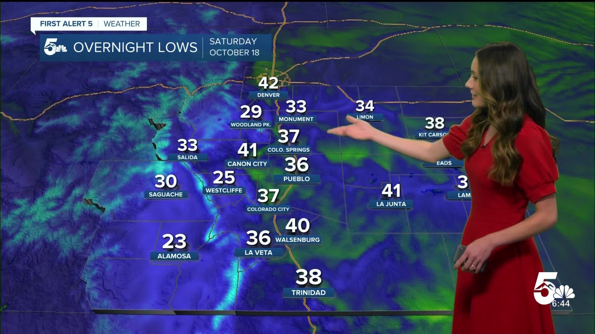
Colorado Springs forecast: Low: 37; High: 66;
The Springs will get into the upper 30s overnight with clear conditions. This will allow for some frost in the area. Wind gusts will get breezy around 10AM and last throughout the majority of the day. Highs will get into the mid-60s.
Pueblo forecast: Low: 36; High: 71;
Pueblo will dip into the mid-30s overnight, but not quite make it to freezing. There is still a possibility of some frost across the area. Temperatures will still get warm in the afternoon, eventually reaching the lower 70s.
Canon City forecast: Low: 41; High: 70;
Canon City will be on the warm side with overnight lows, but still chilly. Lower 40s will be expected in the early morning hours of Saturday. Sunny conditions will help temperatures to warm into the lower 70s by the afternoon. Wind gusts will be between 20 and 30mph at times. This will calm in the evening.
Woodland Park forecast: Low: 29; High: 57;
Woodland Park will be the coldest of the bunch, getting down into the upper 20s tonight. It is a good idea to prepare any pipes and bring in any potted plants. Temperatures in the afternoon will still be on the cooler side in the upper 50s. Wind will also pick up as well in the afternoon, so it will be a good day for a jacket.
Tri-Lakes forecast: Low: 33; High: 60;
The Monument area will be very close to freezing tonight. Frost will likely form across the area. Temperatures in the afternoon will rise into the lower 60s. With strong wind gusts, it wouldn't be a bad idea to get the jackets out.
Plains forecast: Low: 30s & 40s; High: 60s & 70s;
The Plains won't be quite as cold tonight as I-25, but 30s are still possible. By the afternoon on Saturday temperatures will warm into the 60s and 70s. Wind gusts will also pick up during the mid-morning between 20-30mph.
Walsenburg and Trinidad forecast: Low: 40/38; High: 69/70;
The southern I-25 corridor will take a dip into the upper 30s and lower 40s tonight and into tomorrow morning. Winds will be sustained at 10 to 15 mph, but gusts will get up to 30mph. Temperatures will warm with plenty of sunshine into the upper 60s and lower 70s.
Mountains forecast: Low: 20s & 30s; High: 60s;
The mountains will see quite the dip in temperatures tonight into the upper 20s and lower 30s. Many in the area will wake up to frost. Temperatures in the afternoon will get into the lower to mid 60s.
Extended outlook forecast:
Looking ahead, temperatures will rebound back into the 70s for the I-25 corridor. Gusty conditions will pick up again on Monday, but temperatures are still expected to stay warm. We are watching another low-pressure system that looks to arrive Wednesday evening and into Thursday. With the cooler temperatures and increase in moisture this makes a wintry mix possible for the mountains and Woodland Park. I-25 will likely still be too warm for a mix.
____
Curious about the First Alert 5 Weather Storm Impact Scale? Check out our cheatsheet explainer.
Watch KOAA News5 on your time, anytime with our free streaming app available for your Roku, FireTV, AppleTV and Android TV. Just search KOAA News5, download and start watching.
