

Tonight's Forecast:
A few spotty showers will be possible, but mainly towards Baca county and the higher terrain. Clouds will slowly clear out overnight, but closer to the eastern plains fog will move in. This is expected to stay east of I-25. Overnight temperatures will be in the 30s.
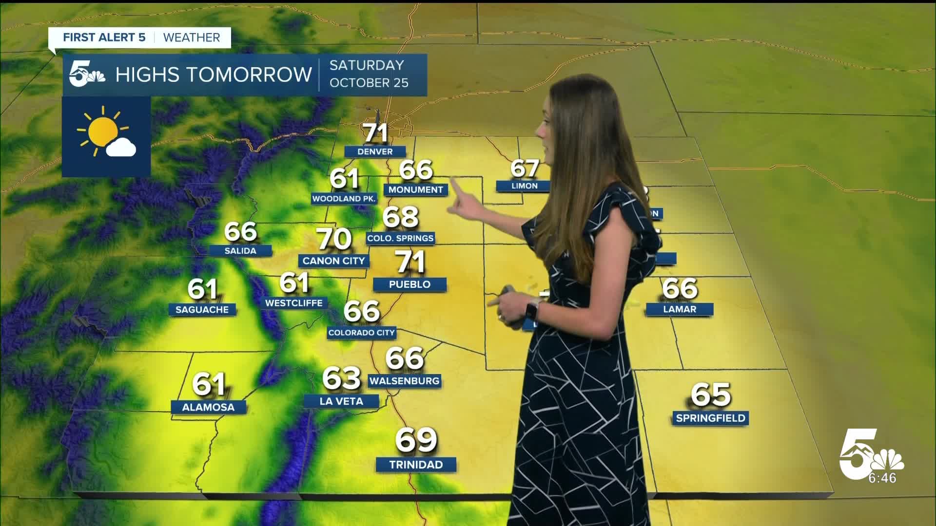
Colorado Springs forecast: Low: 37; High: 68;
Colorado Springs will stay mostly clear for the rest of the evening, except for a couple of clouds. Overnight lows will dip into the upper 30s. By tomorrow afternoon, sunshine will help to warm up the area into the upper 60s. It will be a great day to get outside.
Pueblo forecast: Low: 36; High: 71;
Pueblo will have a warmer evening, but as we get closer to the morning hours this will change dipping into the mid-30s. If you have an early start to your morning, grab that jacket! By the afternoon, temperatures will warm up nicely into the lower 70s.
Canon City forecast: Low: 41; High: 70;
Canon City will have a cooler start to the day with morning lows in the lower 40s. This will be a couple of degrees warmer than the surrounding area. Afternoon highs will be in the lower 70s. Canon City will reach this closer to 3PM. Mostly clear conditions and light winds are expected.
Woodland Park forecast: Low: 30; High: 61;
Woodland Park will be chilly tomorrow morning with temperatures in the lower 30s. Winds will remain light between 5 and 10mph. With sunny skies, afternoon temperatures will get into the lower 60s.
Tri-Lakes forecast: Low: 38; High: 66;
The Tri-Lakes area will dip into the upper 30s tonight. Winds will be light overnight and into tomorrow. This breeze will become more southeasterly throughout the day. This combined with sunny conditions will raise temperatures into the mid-60s, so this is a good day to get outside.
Plains forecast: Low: 30s & 40s; High: 60s & 70s;
The eastern plains will be in the 30s and 40s overnight. With the surge of moisture overnight, fog will move in. This is expected to stay isolated towards our most eastern counties. As the sun rises, this will help to burn off this fog. Afternoon highs will be in the 60s and 70s.
Walsenburg and Trinidad forecast: Low: 36/35; High: 66/69;
The southern I-25 corridor will have overnight lows in the mid-30s. Winds will be light tonight and into tomorrow. Sunny skies and a few clouds will last throughout the day and help temperatures to reach the mid-to-upper 60s.
Mountains forecast: Low: 30s; High: 60s;
The mountains have a couple of inches of snow at the tops of those peaks. This will likely melt over the next few days. Overnight lows will dip into the 30s for the mountains. Highs tomorrow afternoon will reach the 60s. If you plan on traveling to the mountains this will be the day to do so, because another system, bringing snow, will move in on Sunday evening.
Extended outlook forecast:
Looking ahead, temperatures will stay very consistent. Upper 60s will last throughout the weekend. A trough will move through northern Colorado and this will bring breezy conditions to southern Colorado. Snow will impact the mountains above 10,500 feet.
By Tuesday, temperatures will cool into the 50s for a lot of us. This will be the coldest day within the next 7 days. A ridge builds beyond that and mostly clear conditions will keep us warm. No snow in sight yet for southern Colorado.
____
Curious about the First Alert 5 Weather Storm Impact Scale? Check out our cheatsheet explainer.
Watch KOAA News5 on your time, anytime with our free streaming app available for your Roku, FireTV, AppleTV and Android TV. Just search KOAA News5, download and start watching.
