

Today’s Forecast:


We've got a very complicated forecast evolving across southern Colorado today. The basics are blizzard conditions expected from northern El Paso County up through Denver and east on highway 24 to Limon. We'll see very heavy snow but lighter winds in Teller County, and mostly just gusty winds and scattered showers from Canon City to Pueblo.

COLORADO SPRINGS: High: 40; Low: 20. Wide ranging weather is expected across Colorado Springs with heavy snow expected up on the far north side of town closer to Briargate, and blizzard conditions expected on the east side of town. Relatively warm air will limit snow totals south of Briargate, but strong winds could still lead to rough drives at times. If you live east of Academy Road, you'll see wind gusts in the afternoon over 40 mph, with the heaviest snow expected to collect north of Woodmen Road.
WOODLAND PARK: High: 33; Low: 16. Heavy snow is expected through Teller County, but with less wind that we'll see east of the mountains. Wind gusts in the 20 to 30 mph range could still lead to dangerous drives, especially with snow totals ranging from 7 to 11 inches through town. A little less snow is expected south in Cripple Creek, but it will become difficult to drive from lunchtime through the evening.
TRI-LAKES: High: 30s; Low: 10s. Blizzard conditions with heavy snow are expected in the Tri-Lakes region, as well as drives north over Monument hill to Denver. Wind gusts could be in the 40 mph range and snow will likely be heavy enough to create white out conditions, and possibly close I-25 through the Gap. Travel will be very dangerous from lunch time through the evening.

PUEBLO: High: 50; Low: 24. Warm air and strong daytime winds will limit the amount of precipitation that falls in Pueblo. We're expecting to see mostly scattered rain showers in the morning and some in the afternoon, but with very strong winds. Gusts could be up near 50 mph at the strongest today, especially through the afternoon.
CANON CITY: High: 47; Low: 28. Warm air will likely lead to just rain over Canon City and the surrounding towns, and we'll likely have less wind compared to Pueblo. There could be some snow showers in the late day or evening, but with little to no accumulation expected. Be careful driving into the mountains today, where a bit more snow collection is likely.
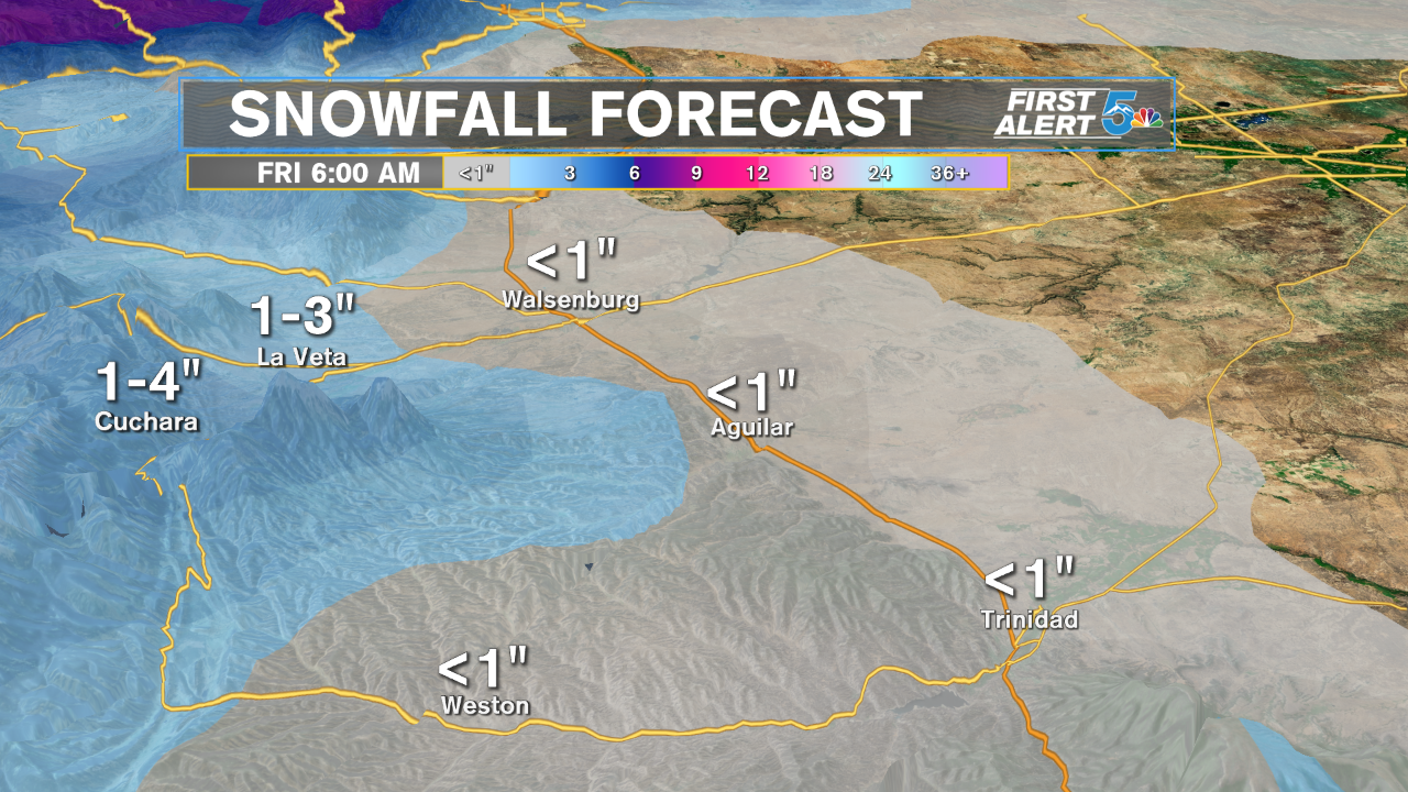
WALSENBURG/TRINIDAD: High: 50s; Low: 20s. Other than scattered morning rain showers, we're forecasting mostly dry skies from Walsenburg to Trinidad until this evening, when light snow is possible. Snow will fall through the day and evening in the mountains near La Veta and Cuchara, but snow totals remain fairly low. Wind gusts will be strongest along and mainly east of I-25
PLAINS: High: 50s; Low: 20s. No snow is expected through the plains east of El Paso and Pueblo counties, but LOTS of wind and scattered rain is. We'll see scattered showers in the morning and afternoon, but the wind is the bigger story. Wind gusts out of the north will blow between 45 to 55 mph for most of the region, meaning semi trucks could tip on east to west drives in the afternoon.
Extended Outlook:
There may be some flurries on Friday in the Pikes Peak Region, but we're mostly going to be dry, cold, and breezy. We'll see warmer and drier air into the weekend with highs warming to the 50s and 60s.
