


Today’s Forecast:
The forecast during the daytime will focus on strong to damaging wind gusts and very high fire danger.
Gusts today will range from 30 to 60 mph once again. We'll see the strongest wind gusts west of I-25 in the mountains and valleys.
Despite there still being pockets of snow around, grass fires are still very likely today and could spread quickly due to the strong winds.
Tonight's Forecast:
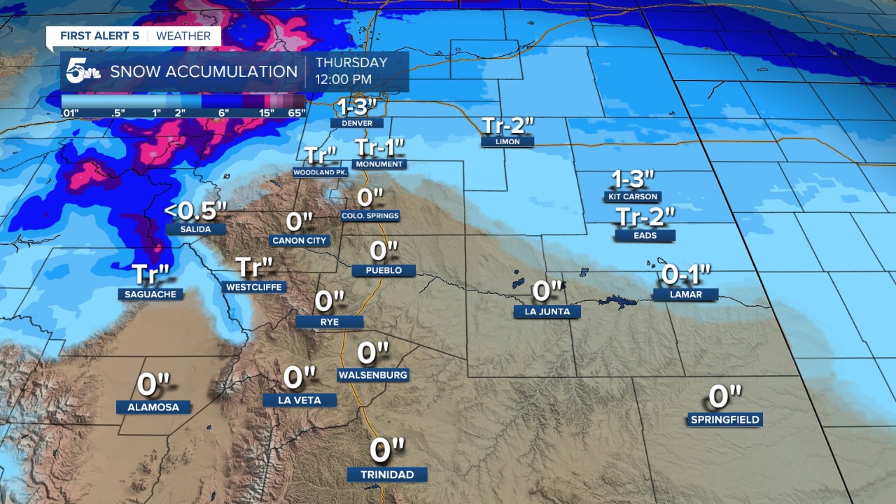
Overnight, light snow and arctic air will slide down from Denver.
Snow totals will be pretty light in our region and stay along or north of the Palmer Divide. Other than stray flurries, no accumulation is expected south of Monument Hill or Gleneagle in the Colorado Springs area.
Arctic air will bring lows down into the single digits with Wind Chill Warnings in effect for almost all counties along the Colorado/Kansas border. Wind chills out east overnight could bottom out near -20 degrees.
COLORADO SPRINGS: High: 46; Low: 6. Windy and dry today with high fire danger in grassy areas through the afternoon. We'll see wind gusts in the 30 to 50 mph range across town with the highest wind gusts on the west side of town near or up into the mountains. Light snow is possible tonight on the far north end of town near areas like Palmer Lake, Monument Hill, Black Forest, and out east near Calhan. Arctic air will push temperatures tonight down into the single digits across the county. Wind chills could get below zero overnight.
PUEBLO: High: 50; Low: 5. Strong gusty winds and high fire danger across Pueblo county today. We'll see wind gusts in the 30 to 50 mph range today with fire danger highest in the dry, grassy areas. Overnight we won't see any snow, but arctic air will be present. Temperatures will fall into the low single digits by Thursday morning with wind chills a few degrees below zero.
CANON CITY: High: 51; Low: 15. Strong winds and high fire danger today through Canon City and the surrounding towns like Florence and Penrose. We'll see wind gusts in the 30 to 50 mph range, but gusts south into the Wet Mountains could be in the 60 mph range.
WOODLAND PARK: High: 40; Low: 16. Chilly and very windy today with gusts in the 40 to 60 mph range through the afternoon. We'll stay dry today but overnight flurries to light snow showers will be possible over northern Teller County. Snow accumulations overnight should stay very light and likely anywhere from a trace to a half inch at the most in Woodland Park. Temperatures will fall into the teens tonight but wind chills should stay above zero.
TRI-LAKES: High: 40s; Low: >10. Very windy and cold today with strong winds through the afternoon and evening hours. Westerly winds during the day will gust between 40 to 60 mph during the day and 20 to 30 mph out of the north tonight. Snow is possible tonight along northern El Paso County but in areas like Monument, Palmer Lake, and Black Forest, we should see snow totals at or less than 1 inch through Thursday morning. Arctic air will push temps into the single digits tonight with wind chills a few degrees below zero.
PLAINS: High: 50s; Low: >10. Windy and dry today with high fire danger across grassy areas. The winds during the afternoon will be strongest as you go west, but Bent, Prowers, Kiowa, and Baca counties could still have gusts in the 20 to 40 mph range. Overnight arctic air and light snow
WALSENBURG/TRINIDAD: High: 50s; Low: 10s. Strong winds and high fire danger along the southern I-25 corridor and west over the mountains. We'll see stronger gusts west of La Veta Pass and out by Cuchara today, but gusts along I-25 from Walsenburg to Trinidad will be between 30 to 50 mph in the afternoon. No snow is expected tonight and temperatures will drop into the teens through Thursday morning.
MOUNTAINS: High: 30/40s; Low: 10s. Strong winds in the mountains today with heavy snow in the central and northern slopes through the overnight hours. WInter Storm Warnings and winter weather advisories are in effect over the high country, so be careful and check ahead if you're heading west. Locally our mountains will be dry today and tonight but we'll see very strong winds. Gusts will be in the 50 to 70 mph range up the mountains, generally over 60 mph when you go above 9,000 feet. We'll see snow showers along the Front Range tonight but the heaviest snow will fall west of Denver.
Extended Outlook:
Arctic air will hang out Thursday in low elevation areas like Colorado Springs down to Pueblo and out east through the plains. Areas like Pueblo and Colorado Springs could see highs in the low 20s while Woodland Park warms to the lower 40s!
We'll be much warmer on Friday with highs back in the 50s and 60s. We'll see a cold front Saturday night bring gusty conditions and a few scattered snow showers through early Sunday morning.
KOAA News5 on your time, streaming on your Roku, FireTV, AppleTV and AndroidTV.
