


Today’s Forecast:
Winter weather returns today with a chilly and windy afternoon followed by accumulating snow tonight.
A strong cold front will move across the Palmer Divide late this morning with northerly winds and constantly cooling temperatures through the afternoon.
Scattered rain and snow showers will fall across the mountains and valleys west of I-25 through the daytime, but most of our impactful and accumulating snow will be tonight and early Friday morning.
The areas that will see the most snow are likely up around the Palmer Divide and Teller County. I-25 and Highway 24 will resist snow accumulation at first, but as temperatures fall below freezing tonight, we could see snow and ice accumulate on the roads.

Colorado Springs forecast: High: 55; Low: 24. Mostly cloudy through the afternoon with cold and windy daytime conditions. A cold front will move through the city around 10 AM with really strong northerly winds gusting to the 30 mph range. Snow showers are expected late today and tonight with low visibility the main issue at the start of the event. Overnight, as temperatures fall below freezing, we could see snow and ice accumulate on less traveled highways and neighborhoods. Citywide, we could see anywhere from a dusting to 2 inches of snow. Totals over an inch are most likely along and north of the Briargate area.
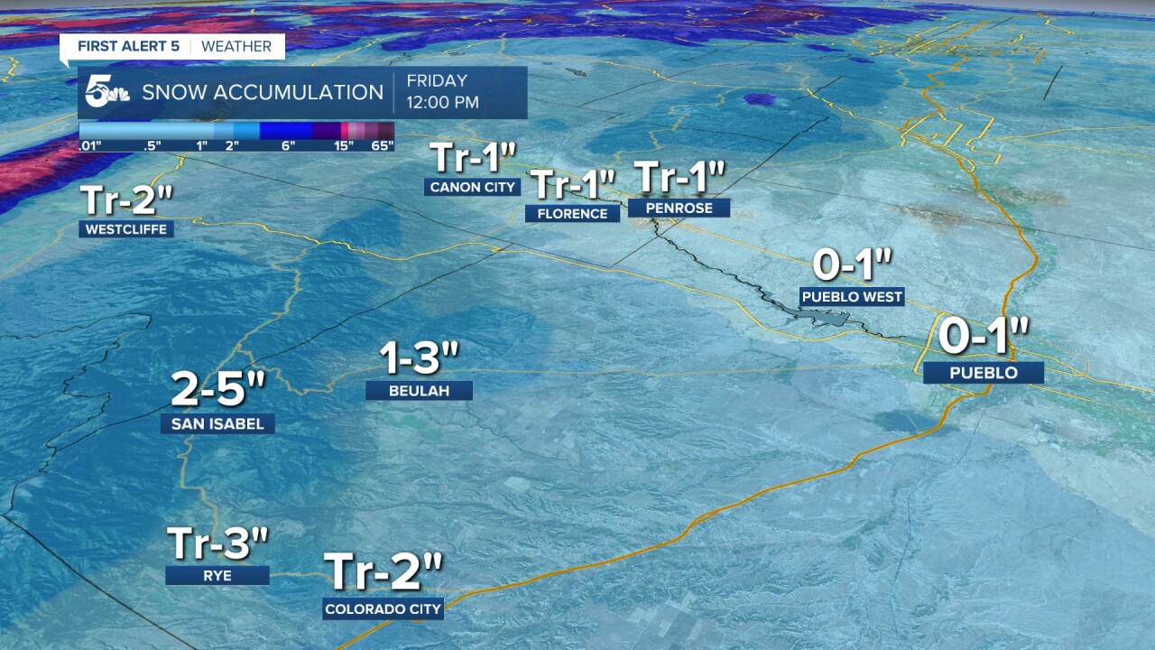
Pueblo forecast: High: 62; Low: 29. Cloudy, windy, and cold in the afternoon with a cold front passing through the city by the mid-afternoon. We'll stay mild ahead of the cold front with temperatures rapidly dropping in the evening. Snow showers are possible tonight and early Friday morning, but accumulations will be light and mostly in the grass. We could see anywhere from a dusting to an inch if we get really lucky.
Canon City forecast: High: 59; Low: 30. Mostly cloudy and breezy with cold air sinking in through the afternoon. Rain to snow showers are going to fall at the end of the day and overnight, but accumulation for most of Canon City and the surrounding lower-elevation towns will be light. We're thinking an inch or less for Canon City through Friday morning, with most of that being in the grass.
Woodland Park forecast: High: 47; Low: 16. Cloudy and cold all day with most of our accumulating snow falling late today and tonight. If we do see any daytime snow showers or flurries before 4 pm, they shouldn't accumulate on the roads. Snow will fall heavier after 4 to 5 pm tonight with ice and snow likely to accumulate on Highway 24 and 67 through early Friday morning. We're calling for 2 to 4 inches in Woodland Park and Cripple Creek, but areas north of Highway 24 could have heavier pockets.
Tri-Lakes forecast: High: 40s; Low: 10s. Cloudy and windy with a strong cold front moving over the Palmer Divide late this morning. Blowing snow is expected to start late today and accumulate overnight, with a general 2 to 4 inches through Friday morning. Blowing snow and some accumulation on I-25, Hwy 105 & 83, are the main travel threats for the evening commute.
Plains forecast: High: 60/70s; Low: 20s. Warm and windy along and south of Highway 50 today with the cold front not really having much of an effect until the end of the day. We'll stay dry until late tonight and early Friday morning when snow showers and flurries spin across the plains. Snow totals east of I-25 will be very light through the plains, and we won't see much accumulation until early Friday morning.
Walsenburg and Trinidad forecast: High: 60s; Low: 20s. Warm and windy through the daytime with afternoon rain or snow showers staying out west near the Sangre De Cristos and San Luis Valley. Our cold front will arrive by the end of the day with rain and snow accumulating late tonight and Friday morning. We won't see an evening commute impact, but it could get slick early Friday morning.
Mountains forecast: High: 40s; Low: 10s. Winter Storm Warnings are in effect over the San Juans with Advisories for the rest of the western mountains and Sangre De Cristos. We'll see scattered daytime snow showers over the Sangres and into the Wet Mountains, but the main snow accumulation in our mountains and valleys happens late today and tonight when the temperatures cool. We could see 1-3 inches around Rye overnight, 2-5 La Veta, and even more up the slopes of the Sangres. Wolf Creek Pass will be extremely dangerous for travel today with I-70 collecting 4 to 8 inches through early Friday morning.
Extended outlook forecast:
Friday morning, we'll be very cold with lighter winds and areas of light snow. Snow showers and flurries will be leaving Colorado to the east, and accumulations after sunrise will be minimal across the plains.
The weekend will be dry, warmer, and windy with elevated fire danger through the afternoon. We don't see any rain or snow until late next week.
____
Curious about the First Alert 5 Weather Storm Impact Scale? Check out our cheatsheet explainer.
Watch KOAA News5 on your time, anytime with our free streaming app available for your Roku, FireTV, AppleTV and Android TV. Just search KOAA News5, download and start watching.
