



Tonight's Forecast:
A couple of showers and storms will move through starting at 10PM. These storms will move in from the north and push southeast. It will take most of the overnight hours for these storms to exit Colorado. Monday morning will have more clouds and a couple of areas with lingering sprinkles. Overnight lows will be in the 30s, 40s and 50s.
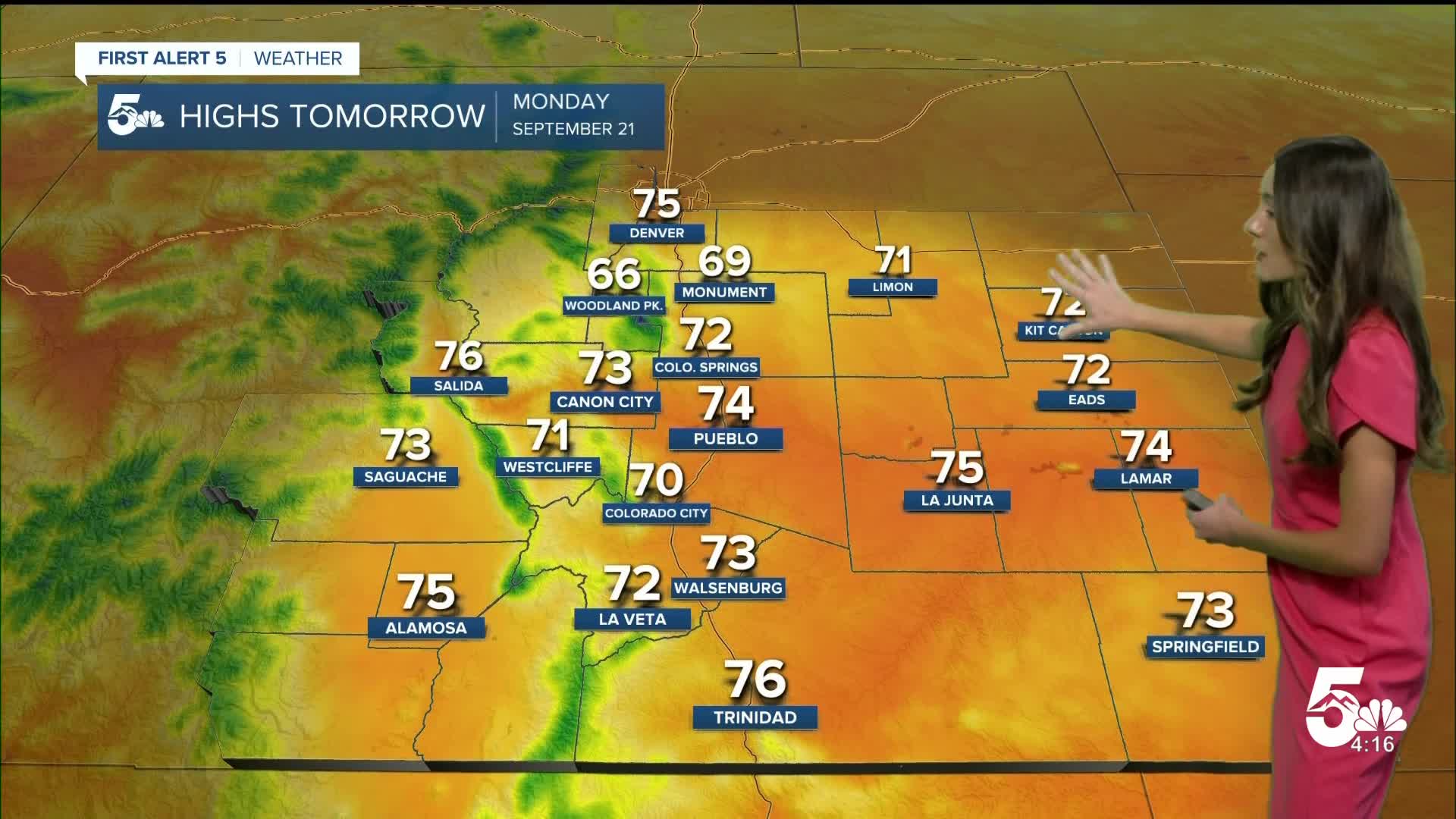
Colorado Springs forecast: Low: 50; High: 72;
Colorado Springs will have some cloud cover in the morning and these will eventually clear out by the afternoon. Another round of showers and storms will push into the Pikes Peak Region after sunset. Highs will be in the lower 70s.
Pueblo forecast: Low: 54; High: 74;
Pueblo will start the day with more cloud cover. Moisture will continue to move in over the next few days and this pattern will bring some rain chances. There will be a chance for some showers and storms later on and overnight into Tuesday. Highs will be cooler, in the mid-70s.
Canon City forecast: Low: 55; High: 73;
Canon City will have morning temperatures in the mid-50s. A few clouds will hang around throughout the day, but there will still be some sunshine. Rain chances increase Monday night and these conditions will clear out by Tuesday. Afternoon highs on Monday will be in the lower 70s.
Woodland Park forecast: Low: 39; High: 66;
Woodland Park will have a couple of rainy days in the forecast. Monday morning will start off with a few clouds and temperatures in the upper 30s. These temperatures will eventually warm into the mid-60s by the afternoon. Rain chances will return in the evening. There will be a 40% chance of rain.
Tri-Lakes forecast: Low: 45; High: 69;
Monument will have morning temperatures in the mid-40s. By the afternoon there will be more clouds and highs will get into the upper 60s. Rain chances will increase throughout the evening.
Plains forecast: Low: 50s; High: 70s;
The eastern plains will have a noisy night with thunderstorms continuing into early Monday morning. Clouds will stay behind and temperatures will dip into the 50s. By the afternoon, temperatures will be in the 70s. Another round of storms will move through after sunset and into early Tuesday.
Walsenburg and Trinidad forecast: Low: 52; High: 73/76;
The southern I-25 corridor will have partly cloudy skies throughout the day on Monday. Temperatures will start off in the lower 50s and eventually get into the lower-to-mid 70s. Rain chances will return in the evening.
Mountains forecast: Low: 30s & 40s; High: 70s;
The mountains will have some moisture increase over the next several days. Rain will be possible every afternoon and clear out overnight. Highs will be in the 70s.
Extended outlook forecast:
Moisture will be on the rise over the next several days and keep temperatures cool. 70s and 80s are in the forecast this week. Rain chances will calm once we get around Friday.
____
Curious about the First Alert 5 Weather Storm Impact Scale? Check out our cheatsheet explainer.
Watch KOAA News5 on your time, anytime with our free streaming app available for your Roku, FireTV, AppleTV and Android TV. Just search KOAA News5, download and start watching.
