

Tonight's Forecast:
Storms will fizzle out shortly after the sun sets. A few clouds will stick around, but by the early morning hours on Sunday we will have mostly clear conditions. Morning lows on Sunday will be in the 50s and 60s across the area.
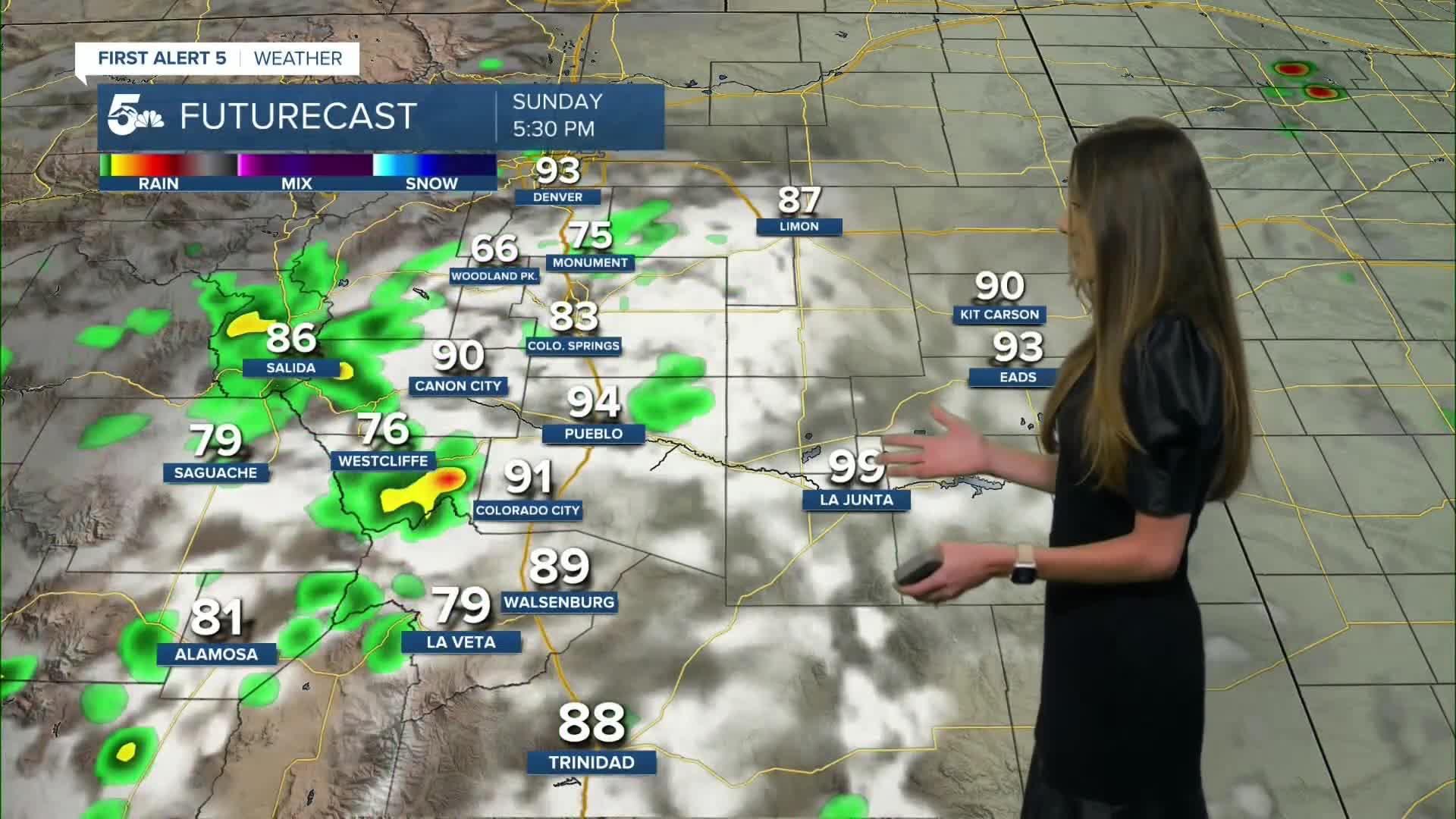
Storms will be possible again in the afternoon with the main activity closer to the higher terrain. Showers and thunderstorms will start popping up around noon and work their way onto I-25. The plains will have a possibility of seeing a few of these storms. Gusty winds and lightning will be possible with these storms.
Colorado Springs forecast: Low: 62; High: 89;
The springs will have overnight lows in the lower 60s. Temperatures on Sunday will be a touch warmer in the upper 80s. Storms will move into the area around 3PM. These storms will stick around a little bit longer but will clear out overnight and into Monday morning.
Pueblo forecast: Low: 63; High: 97;
Pueblo will have temperatures tonight in the lower 60s. Clouds will continue to clear and by the morning there will be mostly clear conditions. Temperatures will be hot again in the upper 90s. There is not as much of a chance for rain in Pueblo, but a spotty shower is still possible.
Canon City forecast: Low: 64; High: 93;
Canon City will continue to clear out overnight and morning lows on Sunday will be in the lower-to-mid 60s. Spotty showers will pop up around 12:00/1:00 PM. There will likely be another wave of rain that moves in closer to the dinnertime hours, but this will clear out overnight.
Woodland Park forecast: Low: 52; High: 76;
Woodland Park will have temperatures drop into the lower 50s overnight. Highs on Sunday will be in the mid-70s. Showers and thunderstorms will be possible throughout the day and some of these storms will produce some gusty winds and heavy rain.
Tri-Lakes forecast: Low: 60; High: 83;
Monument will drop into the lower 60s tonight and tomorrow afternoon will have temperatures in the lower 80s. Some showers and storms will pop up in the afternoon with a few producing some gusty winds and lightning. Storms will clear out later on in the evening and a few clouds will remain.
Plains forecast: Low: 60s; High: 90s;
The plains will have a warm night with temperatures in the 50s and 60s. Highs going into Sunday afternoon will be in the 90s across the area. There will be a few spotty storms, but they won't be quite as widespread as Saturday's storms.
Walsenburg and Trinidad forecast: Low: 60/61; High: 90/93;
For the southern I-25 corridor overnight temperatures will be in the lower 60s. A few storms will pop up in the afternoon and last through the evening. These storms will lend a little earlier on around 5PM.
Mountains forecast: Low: 50s; High: 80s;
The mountains will have widespread rain and some of these thunderstorms will produce heavy rain at times. Lightning and gusty winds will also be a possibility with a few of these storms. Highs will be in the 80s.
Extended outlook forecast:
More of a monsoon pattern will pick up going into the work week and there will be a chance for daily afternoon thunderstorms. Once the moisture really picks up around Wednesday, there will be some heavy rain. There is a concern with flash flooding considering how much rain that we have already received across the area. This is something that we will continue to watch.
____
Curious about the First Alert 5 Weather Storm Impact Scale? Check out our cheatsheet explainer.
Watch KOAA News5 on your time, anytime with our free streaming app available for your Roku, FireTV, AppleTV and Android TV. Just search KOAA News5, download and start watching.
