


Today’s Forecast:
Many roads are slick today due to snow over the last 48 hours with temperatures cold enough for frostbite to damage exposed skin in less than 20 minutes.
The big story today will be the lingering arctic airmass with more spotty daytime flurries. Not much more snow accumulation is expected, but easterly upslope winds could continue to drop spotty flurries off and on through the afternoon.
Some of the coldest air of the weekend arrived overnight with morning lows on Monday spread between negatives and single digits. Wind chill values as of 3:30 AM were split between 0° and -30° along and east of I-25.
Current Pikes Peak Region Wind Chill: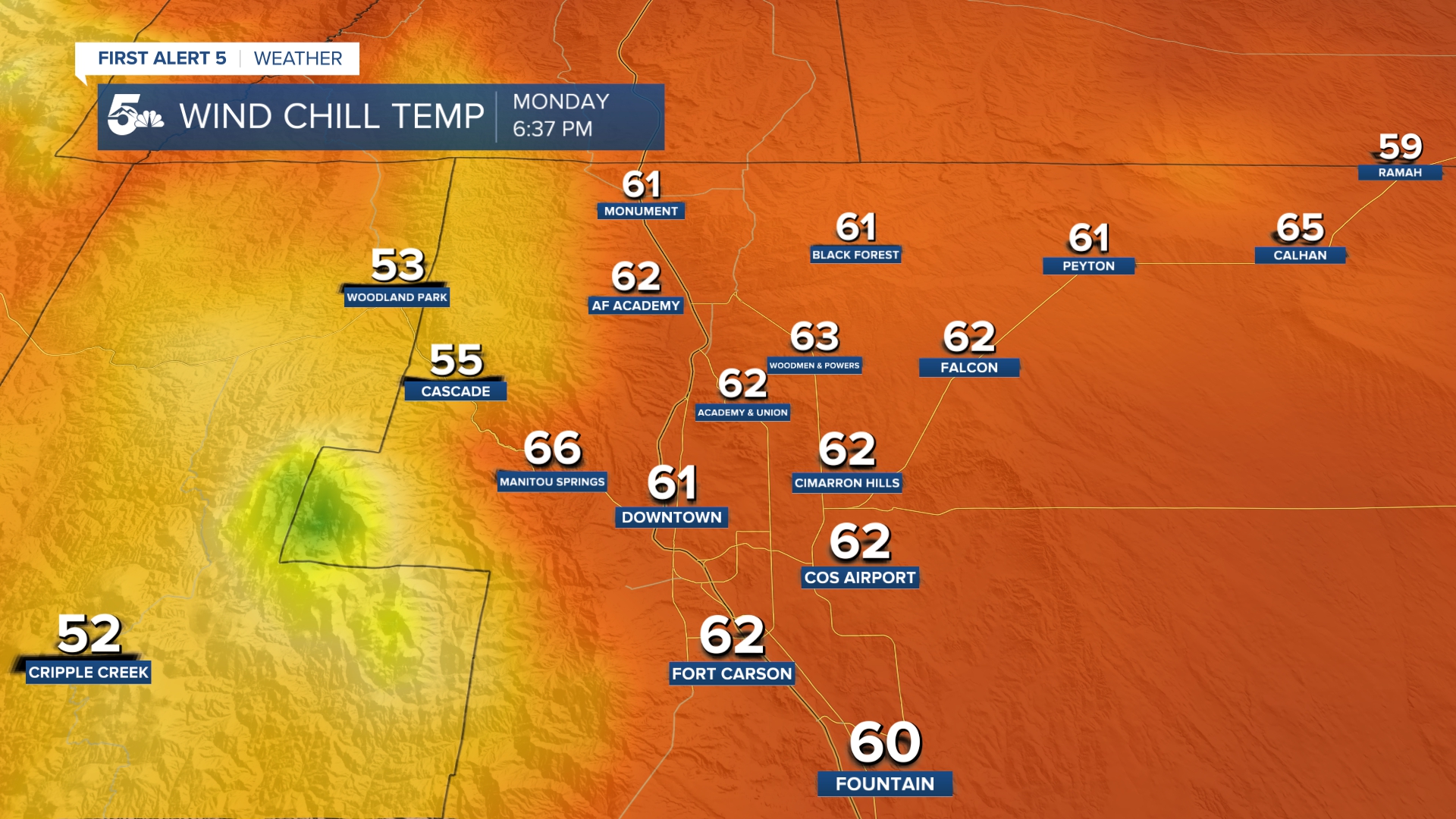
Current Southern Colorado Wind Chill: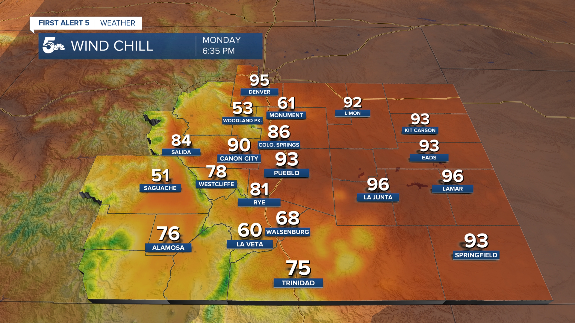
An important reminder on days like this is the danger of frostbite. Frostbite can occur in less than 20 minutes to exposed or poorly covered skin with temperatures and wind chills in the negatives. Fingers, toes, and uncovered parts of your face like your nose are the most susceptible parts of the body to frostbite.
Colorado Springs forecast: High: 13; Low: -1. Mostly cloudy with dangerous cold and spotty daytime flurries. Light easterly winds will keep the chance for spotty flurries through the afternoon but no new accumulation is expected. Overnight, the winds will become calm but the actual air temperatures will be very dangerous with lows likely just below zero.
Pueblo forecast: High: 15; Low: 0. Mostly cloudy, dangerously cold, and breezy with a few daytime flurries. If we do see more flurries today, we won't see any accumulation. Overnight, the winds will become calm with lows falling below zero.
Canon City forecast: High: 25; Low: 4. Mostly cloudy and extremely cold with highs in the 20s through the afternoon. Arctic air will not move west as easily today, so Fremont County in general will be warmer than Pueblo. We should be dry today with isolated flurries possible east near the Pueblo county border.
Woodland Park forecast: High: 29; Low: 2. Mostly sunny and cold, but nowhere near as cold as Colorado Springs! Teller County sits above the arctic air today, so we should stay dry with highs in the low 30s. Tonight will still be very cold with lows close to zero.
Tri-Lakes forecast: High: 10s; Low: >0. Mostly cloudy and dangerously cold, especially with the wind chill factor. Daytime wind chills could be in the deep negatives most of the day with a small chance of an isolated, non-accumulating flurry. Overnight we'll be dangerously cold with lows in the negatives.
Plains forecast: High: 10s; Low: >5. Dangerously cold with mostly cloudy skies and a few isolated flurries through the afternoon. Daytime temperatures will "warm" to the teens but wind chills will be in the deep negatives through the afternoon. Overnight we'll see more dangerous cold with lows falling to the negatives and low single digits.
Walsenburg and Trinidad forecast: High: 20s; Low: >10. Mostly cloudy, breezy, and cold today, but nowhere nearly as cold as areas north near Pueblo and the Highway 50 corridor in general. Temperatures will warm to the upper 20s and low 30s along the southern stretch of I-25 with dry daytime conditions. Overnight it'll be very cold with lows in the single digits.
Mountains forecast: High: 30s; Low: >10. Most of the mountains and valleys, while still being very cold in the morning, will actually have a nice day as they sit above the arctic air trapped in the plains! Highs should warm to the 30s across most of the mountains and valleys during the daytime with snow falling across the Continental Divide. I-70 and ski area travel could be hazardous today with heavy accumulations farther west into the high country through the evening.
Extended outlook forecast:
Tuesday will be the last really cold day of the week with a dramatic warm-up expected by Friday!
Highs should be back in the 40s across the plains by Wednesday with 50s by Friday! We don't see any rain or snow locally in the forecast this week.
____
Curious about the First Alert 5 Weather Storm Impact Scale? Check out our cheatsheet explainer.
Watch KOAA News5 on your time, anytime with our free streaming app available for your Roku, FireTV, AppleTV and Android TV. Just search KOAA News5, download and start watching.
