Tonight's Forecast:
Tonight will bring more clouds as our next system moves into the area. Snow won't arrive until tomorrow evening for I-25. Overnight lows will drop into the teens with wind chills in the single digits.
Tomorrow's Forecast:
Tomorrow is tricky because of how dry this system is. With not that much moisture and winds donwsloping off of the Palmer Divide this will cut off snow from some areas. Now where exactly these cut offs occur is the question. This is why some areas have some higher ranges of snow accumulations. Across the board temperatures will be cold and layers will be needed if you are heading out.
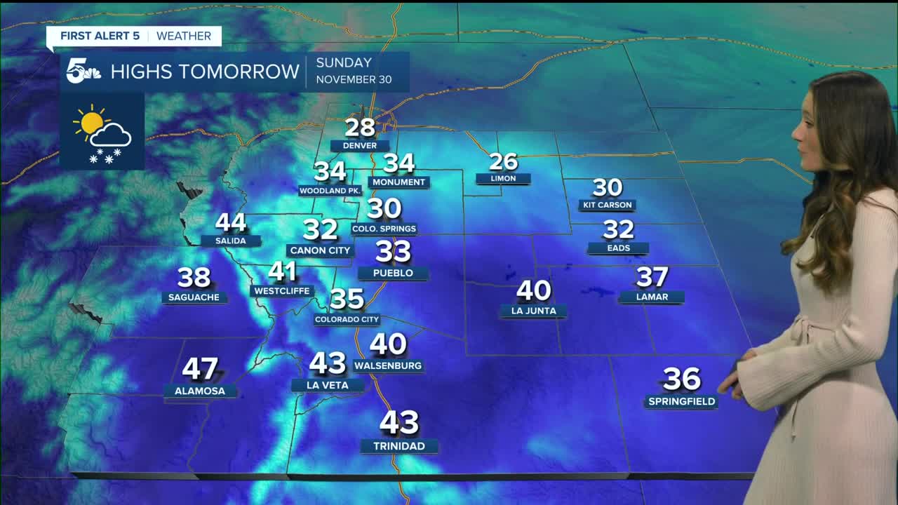
Colorado Springs forecast: Low: 14; High: 30;
Colorado Springs will be waking up to temperatures in the teens. Afternoon highs will not make it above freezing. You will notice an increase in clouds from our next incoming system. Snow will arrive around dinner time. The Springs has a difficult forecast with some sharp cut offs in snow totals. The northern portion of the springs as a much better chance at snow than the south side (near Fountain). Some areas may only receive a trace of snow while others will get an inch or so.
Pueblo forecast: Low: 15; High: 33;
Pueblo actually has a better chance at getting snow accumulations than Colorado Springs. There is more lift over the area to get more snow showers across Pueblo. Snow is set to arrive later on Sunday. Throughout the day there will be increasing cloud cover. Snow ranges from 0-2" for Pueblo.
Canon City forecast: Low: 15; High: 32;
Canon City will be right around freezing for highs. With this system arriving after sunset temperatures will continue to cool into the 20s. Temperatures will not be an issue with this system but rather moisture. Canon City will range from 0-1" of snow going into Monday morning.
Woodland Park forecast: Low: 13; High: 34;
Woodland Park usually luck out with the higher totals and this time they are on an even playing field. This system will move through around dinner time but snow will start accumulating overnight into Monday. Snow ranges form a Tr-2".
Tri-Lakes forecast: Low: 13; High: 34;
The Monument area will have overnight lows in the teens and throughout the day more clouds will move in. Snow arrives around 5PM tomorrow. Snow accumulations will be between 0-2".
Plains forecast: Low: Teens & Single Digits; High: 30s & 40s;
The Plains will not be left out with temperatures dipping into the teens and even single digits overnight. There is still a small chance for a trace of snow along Hwy 50 and our eastern plains.
Walsenburg and Trinidad forecast: Low: 14/15; High: 40/43
The southern I-25 will have the biggest impacts with this system. Snow showers will get lift as these showers move south. The highest totals will be closer to La Veta Pass and the Sangre de Cristos. Walsenburg could receive anywhere from 0-3" while Trinidad is closer to 0-2".
Mountains forecast: Low: Teens; High: 30s ;
The mountains will have snow showers first and starting around noon. This will become heavier throughout the day. If you are traveling any mountain passes it is crucial to have proper tires and chains. Winter Weather Advisories are in place until Monday morning.
Extended outlook forecast:
Snow will wrap up on Monday, and by Tuesday only a few clouds remain. Temperatures will stay cold with the warmest day on Tuesday. There is another chance of snow on Wednesday, but there are still some things to iron out with that forecast. This system so far doesn't look impressive, but this could change.
____
Curious about the First Alert 5 Weather Storm Impact Scale? Check out our cheatsheet explainer.
Watch KOAA News5 on your time, anytime with our free streaming app available for your Roku, FireTV, AppleTV and Android TV. Just search KOAA News5, download and start watching.


