

Tonight's Forecast:
A cold front will bring changes overnight with snow beginning around 4-5AM. Winds will shift out of the north/northwest. Most of the snow will fall overnight and will clear out by the afternoon on Sunday. Temperatures will drop into the teens and 20s.
Tomorrow's Forecast:
Snow will end from north to south with the plains and I-25 having snow showers continue later. Most of the area will have limited snow totals, but the mountains and higher terrain will still get a couple of inches. Winter storm warnings and winter weather advisories are in place for the mountains. If you plan on traveling on I-70 or out west, drive carefully.
Colorado Springs forecast: Low: 22; High: 33;
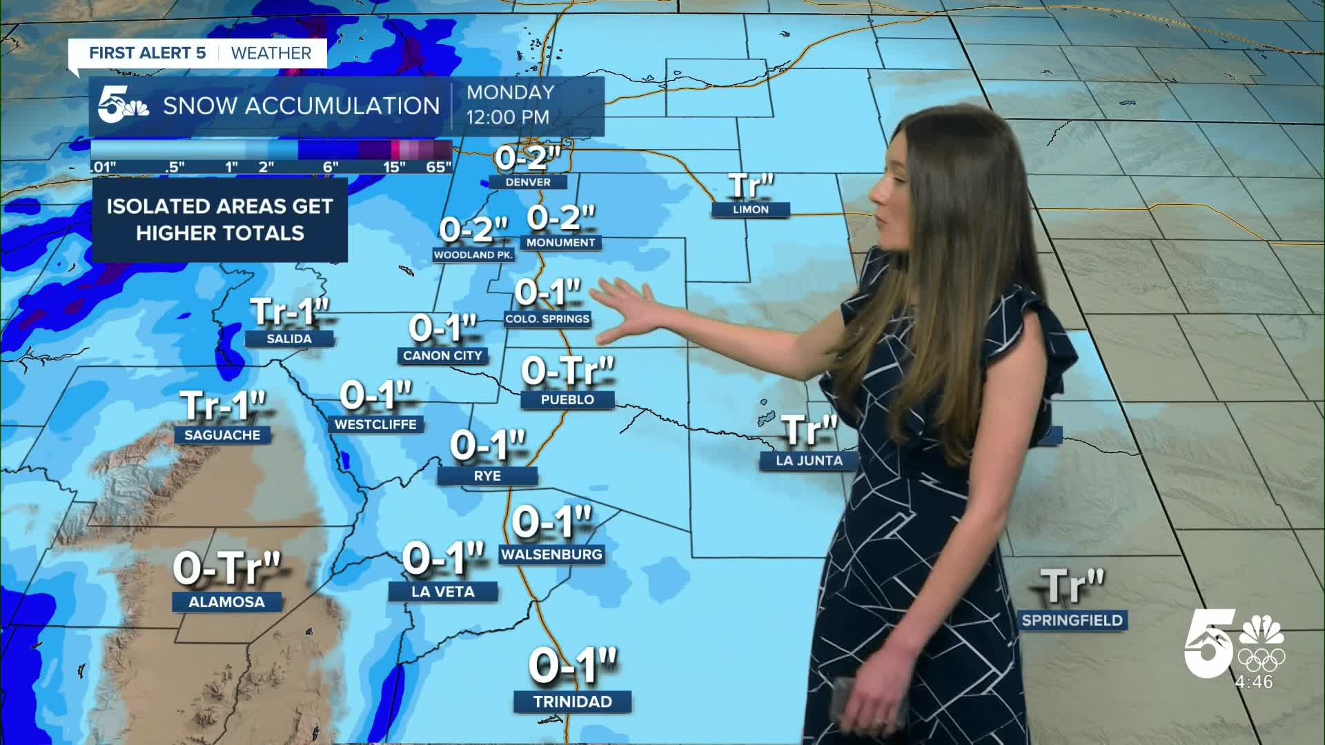
Colorado Springs will drop into the 20s overnight. Northern El Paso county and closer to Monument have a better chance at getting some higher totals. By "higher" totals this will be close to 1-2 inches. Calhan and Black Forest still have a chance at seeing similar totals too. Downtown Colorado Springs will likely get an inch at most. There is still a small chance at receiving more than this, but it doesn't look likely. Snow will end by the time we get into the afternoon.
Pueblo forecast: Low: 27; High: 36;
Pueblo will have overnight temperatures in the upper 20s. Since Pueblo is at a lower elevation, this will not help with snow accumulations. Up to a trace of snow is possible for this area. Snow will wrap up before the afternoon. Clear skies will move in behind the snow. Highs will be cold and only make it into the mid-30s.
Canon City forecast: Low: 27; High: 37;
Canon City will dip into the upper 20s. Snow moves in overnight around 5/6AM. Snow will continue into the morning, but will wrap up by the afternoon. Highs will be on the chilly side in the upper-30s.
Woodland Park forecast: Low: 13; High: 26;
Woodland Park has the best chance at snow overnight. Temperatures will drop into the teens. Between 0-2" are possible. Highs will be in the mid-20s by the afternoon.
Tri-Lakes forecast: Low: 16; High: 29;
Monument will have overnight lows drop into the mid-teens. Some stronger snow bands are possible, which would mean sharp cut offs in snow totals. Between 0-2" are possible in the area. Further north, along the Palmer divide there will be similar conditions. Drive with caution because there will be slick spots on I-25.
Plains forecast: Low: 20s; High: 30s;
The eastern plains will have 20s overnight. Not as much snow is expected out this way with the majority of the area only receiving a trace. Snow will be a little more delayed and will arrive around 7AM and will wrap up a little later. This area will have some warmer temperatures and highs will make it above freezing.
Walsenburg and Trinidad forecast: Low: 26; High: 33/32;
The southern I-25 corridor will continue with gusty conditions overnight. This front will move thorugh during the early morning hours on Sunday. Temperatures will drop into the 20s. Snow will begin shortly after this front moves through. Up to an inch is possible with this system. Highs will be in the lower 30s.
Mountains forecast: Low: Teens & 20s; High: 20s & 30s;
The mountains have winter weather advisories and winter storm warnings in place through Sunday. Snow will wrap up during the afternoon. Highs will be cold, and only make it into the 20s and 30s.
Extended outlook forecast:
Cold air will remain on Monday, but highs will be a few degrees warmer. Above average temperatures will return by Tuesday right as we ring in the new year. These temperatures will climb higher on New Year's Eve and day. Highs during this period will be in the 50s and 60s.
____
Curious about the First Alert 5 Weather Storm Impact Scale? Check out our cheatsheet explainer.
Watch KOAA News5 on your time, anytime with our free streaming app available for your Roku, FireTV, AppleTV and Android TV. Just search KOAA News5, download and start watching.
