

Tonight's Forecast:
Clear conditions will remain for I-25 and the plains. Temperatures will drop into the 30s and 40s overnight. Winds will remain light.
Tomorrow's Forecast:
The day will start off clear and afternoon highs will still be warm. 60s and 70s along I-25 by the afternoon. Rain won't move in until the evening between 5-7PM. The southern I-24 corridor will likely steer clear of any rain.
Colorado Springs forecast: Low: 39; High: 68;
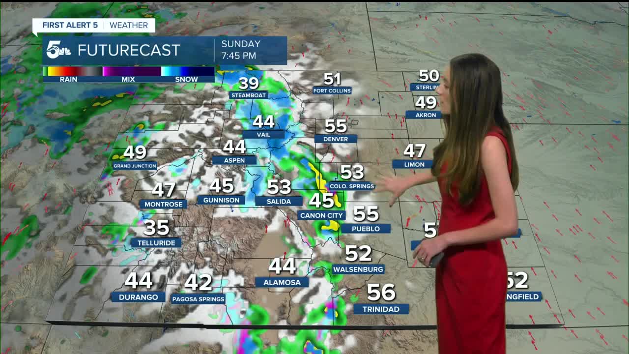
Colorado Springs will dip into the upper 30s overnight. Clear conditions will latst throughout the majority of the day. Once we get to the dinner time hours, that when rain will roll in. These showers will be isolated and not everyone will see rain.
Pueblo forecast: Low: 34; High: 72;
Pueblo will have morning temperatures in the 30s. Temperatures quickly warm up and by the afternoon, highs will be in the lower 70s. This is about 15 degrees above normal for this time of year. Rain chances pick up in the evening. Best chance for rain will be on the north side of Pueblo.
Canon City forecast: Low: 44; High: 68;
Overnight, temperatures will drop into the 40s across Fremont county. Afternoon highs will be in the 70s with winds remaining light. More clouds will increase in the evening along with some rain chances.
Woodland Park forecast: Low: 35; High: 61;
Woodland Park will remain calm and clear overnight. Temperatures will reach the 60s throughout the day and there is a chance for a mix by the evening. The moisture needs to remain in place long enough for temperatures to get closer to freezing.
Tri-Lakes forecast: Low: 39; High: 67;
The Monument area will drop into the upper 30s overnight. Sunny skies will help temperatures to reach the upper 60s by the afternoon. It wouldn't be surprising to see a rain/snow mix overnight. With temperatures taking a few hours to cool it will start off as rain and transition over to snow around 2am.
Plains forecast: Low: 30s; High: 70s;
The eastern plains are warm and dry going into Sunday and it will continue. No rain is foretasted to enter the area. Highs will reach the 70s throughout the area.
Walsenburg and Trinidad forecast: Low: 41; High: 69/73;
The southern I-25 corridor doesn't have the best chances of seeing rainfall, but it's not completely out of the question. If rain moves into the area it will be very isolated. Highs in the afternoon will reach the upper 60s and lower 70s.
Mountains forecast: Low: 30s; High: 50s & 60s;
The mountains will be the ones to get the snow. Snow levels will be around 10,000 feet. Higher mountain passes will be slick and hard to travel at times. This will start Sunday afternoon for the very western part of the state and Sunday evening for most of the ski resorts.
Extended outlook forecast:
A parade of systems will move through this week and break up our boring weather pattern. We have a couple of chances to see some flurries across the area. Hopefully, this brings some beneficial moisture to the area because some areas need it. Wednesday and into Thursday will be the next incoming system.
____
Curious about the First Alert 5 Weather Storm Impact Scale? Check out our cheatsheet explainer.
Watch KOAA News5 on your time, anytime with our free streaming app available for your Roku, FireTV, AppleTV and Android TV. Just search KOAA News5, download and start watching.
