

Today’s Forecast:
Southern Colorado saw a mix of snow and rain overnight, with the heaviest snow collecting in El Paso County and the Wet Mountains.
More rain and snow will push in from the south through the morning and linger a little longer than expected into the afternoon. We should be dry by tonight across the region.

Temperatures will warm into the 30s and 40s this afternoon, so we'll keep the pavement wet to slushy through the end of the day. Temperatures will dip below freezing tonight which will likely lead to ice accumulation on wet and slushy roads.
COLORADO SPRINGS: High: 39; Low: 24. We will keep seeing areas of light to moderate snow through the morning with dry skies into the afternoon. We could see another half-inch to two inches across town through the morning, but the pavement will want to stay slushy and then turn wet in the afternoon. Freezing temperatures tonight could lead to a re-freeze.
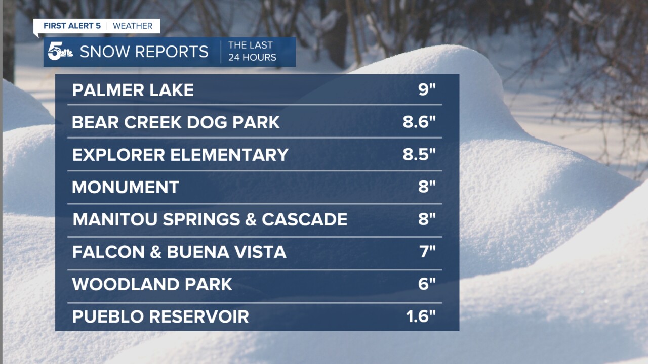
PUEBLO: High: 44; Low: 26. Rain showers, possibly with an early morning flurry, will be possible through the morning with dry skies by the end of the day. No additional snowfall is expected today, but tonight freezing temperatures could lead to icy stairs and sidewalks.
CANON CITY: High: 41; Low: 28. Snow to rain showers through the morning with only a half-inch to an inch more snow expected, and most of that would be on the grass. We'll be dry late today and tonight with a re-freeze possible overnight.
WOODLAND PARK: High: 33; Low: 16. Additional light snow showers will fall through the morning but snow accumulations should stay at or under 2 inches for most of Teller County. As in most areas we could see a re-freeze tonight as temperatures dip below freezing.
TRI-LAKES: High: 30s; Low: 10s. Heavy to moderate snow through the morning with dry skies through the afternoon. Additional snow could be anywhere from 1 to 4 inches, mostly in the grassy areas. We'll be dry but frozen tonight and so we'll see plenty of icy areas in your neighborhoods and side streets.
PLAINS: High: 40s; Low: 20s. Areas of snow and rain through the morning and afternoon. We'll see snow mixed with rain fall primarily south of Highway 50 this morning with 3 to 6 inches possible in Las Animas county around Kim on Highway 160. A lot of snow that falls will melt, but we'll see areas of rain along and north of Highway 50 through the afternoon. Cold temperatures tonight could lead to icy and frosty areas.
WALSENBURG/TRINIDAD: High: 30s; Low: 20s. Snow showers mixed with rain at times through the morning and early afternoon with dry skies by the end of the day. An additional 2 to 4 inches could fall in this stretch of I-25, but the roads will probably stay warm enough where the snow is wet or slushy on the pavement. We'll be dry but below freezing tonight so icy areas will be common.
MOUNTAINS: High: 40s; Low: 20s. Heavy snow over the eastern slopes of the Sangres and especially the Wet Mountains through the morning with dry skies in the afternoon. We'll stay breezy and cold today with lighter winds overnight.
Extended Outlook:
The next chance for rain and snow comes Tuesday night through Wednesday morning, but there won't be much snow or rain accumulation through the region. We could get rain showers on Friday, but the weekend looks dry!
KOAA News5 on your time, streaming on your Roku, FireTV, AppleTV and AndroidTV.
News5 App | First Alert 5 Weather App | Youtube | Facebook | Instagram | Twitter
