

Tonight's Forecast:
There will be a few clouds throughout the Pikes Peak Region overnight. Temperatures overnight will be in the 50s for the I-25 corridor. Closer to the mountains, temperatures will be a touch cooler in the 40s and 50s.
Tomorrow's Forecast:
The Storm Prediction Center has a slight risk for parts of eastern Colorado. The main threats are winds up to 70mph and large hail. These storms will start to pop up over northern El Paso county, but it will take a few hours for these storms to reach a more favorable environment. The southern I-25 corridor will not have as much of a risk.
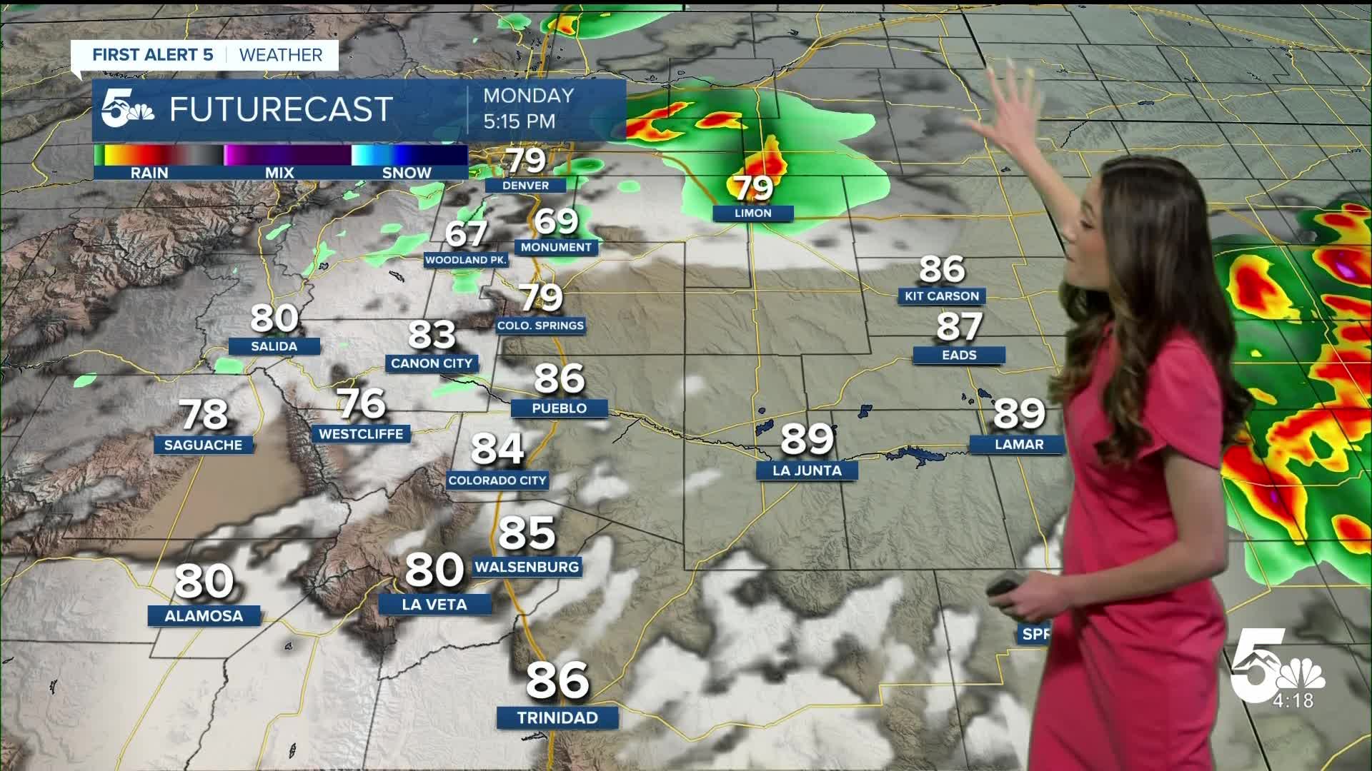
Colorado Springs forecast: Low: 50; High: 81;
Colorado Springs will have sunshine to start off the day and lows will be in the lower 50s. Thunderstorms will be possible for northern El Paso county. Colorado Springs is included in the Marginal Risk (1/5) for the severe potential. These storms will be isolated, so not everyone will have thunderstorms. Afternoon highs will be in the lower 80s.
Pueblo forecast: Low: 54; High: 86;
Pueblo will have morning temperatures in the mid-50s. Temperatures will warm quickly, and will be similar to the past few days. Afternoon highs will be in the mid-80s. Pueblo is also included in the Marginal Risk (1/5) for severe weather.
Canon City forecast: Low: 53; High: 83;
Canon City will have temperatures in the lower-50s to start off the day. Temperatures will warm quickly, and afternoon highs will have lower-80s. An isolated shower or two will move through Fremont county in the afternoon and evening.
Woodland Park forecast: Low: 43; High: 71;
Woodland Park will have temperatures in the lower 40s. Showers and thunderstorms will begin in the afternoon, and will last into the later part of the day. Temperatures will get into the lower 70s by the afternoon.
Tri-Lakes forecast: Low: 48; High: 77;
Monument and the surrounding areas will have morning temperatures in the upper 40s. There is a possibility of some stronger storms in the afternoon. Hail, strong winds, and lightning will be possible. Even with rain in the forecast, highs will be near average in the upper 70s.
Plains forecast: Low: 50s; High: 80s;
The eastern plains have the greatest risk for severe weather. Kit Carson is included in the slight risk (2/5), while Eads, Lamar, and La Junta are in the Marginal Risk (1/5). Large hail, winds up to 70 mph, and lightning will be a possibility. Afternoon highs will be in the 80s throughout eastern Colorado.
Walsenburg and Trinidad forecast: Low: 51/50; High: 84/86;
The southern I-25 corridor will not be included in the severe weather potential for Monday. The morning temperatures will be in the lower 50s. By the afternoon there will still be some clouds and some isolated showers. Afternoon temperatures will be in the mid-80s.
Mountains forecast: Low: 40s; High: 70s/80s;
The mountains will have lows in the 40s. Showers and thunderstorms will pop up in the afternoon. Highs will be in the 70s and 80s.
Extended outlook forecast:
Tuesday will still have the chance for some severe weather, but not as impactful as Monday. Hail, gusty winds, and lightning are possible with a few storms. Parts of Colorado have a Marginal Risk (1/5) for severe weather. Wednesday looks gloomy, with the day starting off with more clouds. Rain moves in by the afternoon. Highs will stay pretty consistent throughout the week. Still a chance for an isolated shower or two on Thursday, but most of our area will stay dry.
____
Curious about the First Alert 5 Weather Storm Impact Scale? Check out our cheatsheet explainer.
Watch KOAA News5 on your time, anytime with our free streaming app available for your Roku, FireTV, AppleTV and Android TV. Just search KOAA News5, download and start watching.
