

Tonight's Forecast:
Temperatures are slowly cooling due to some storms and showers across the area. Most of the rain will likely not reach the surface due to how dry it is. Temperatures will still be warm though int the 90s and triple digits. Overnight lows will be in the 50s for the higher terrain and 60s for I-25 and the plains. A few mid to upper level clouds will move into the area in the afternoon, but won't offer much relief from the heat.
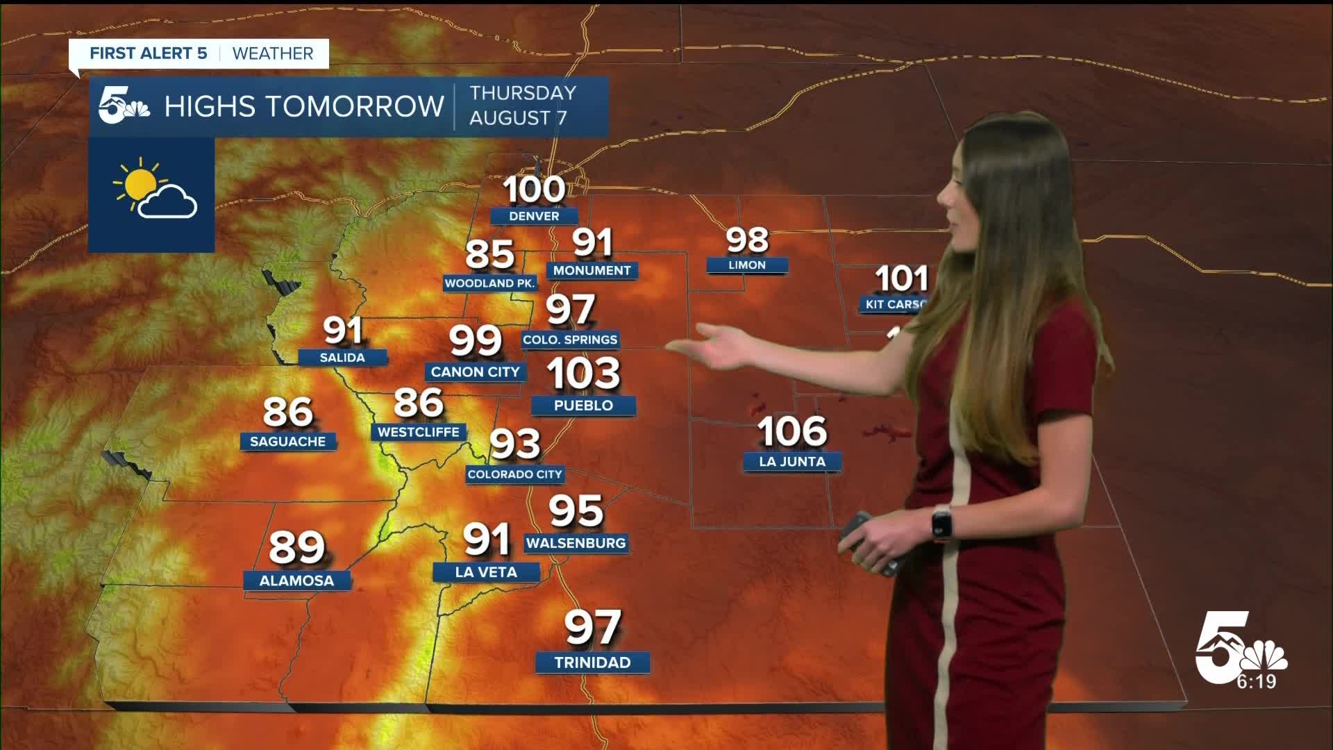
Colorado Springs forecast: Low: 62; High: 97;
Colorado Springs will slowly cool throughout the evening with some higher to mid level clouds. It will take a few hours for things to cool into the 70s and 60s. Overnight lows will be in the lower 60s. Highs tomorrow will be much warmer in the upper 90s. Heat advisories for El Paso county will be in place from 11AM until 8PM.
Pueblo forecast: Low: 63; High: 103;
Pueblo will slowly cool into the lower 60s this evening with a few clouds throughout the area. Temperatures going into Thursday will continue to warm into the triple digits. There will also be a heat advisory for Pueblo county starting at 11AM and lasting until 8PM.
Canon City forecast: Low: 65; High: 99;
Canon City will have some fire danger concerns for Thursday. Dry conditions along with stronger wind gusts will heighten the fire risk. Temperatures are expected to get into the upper 90s and potentially push into the triple digits by the afternoon. A heat advisory will be in place from 11AM until 8PM for parts of Fremont county.
Woodland Park forecast: Low: 55; High: 85;
Woodland Park will have a few passing showers this evening. Things will clear out overnight. Temperatures will dip into the mid-50s by the early morning hours on Thursday. By the afternoon, temperatures will rise into the mid-80s.
Tri-Lakes forecast: Low: 62; High: 91;
The Monument area will have some gusty winds this afternoon from some showers and thunderstorms over the higher terrain, but things will calm down overnight. Overnight lows will drop into the lower 60s. Highs tomorrow will be in the lower 90s.
Plains forecast: Low: 60s; High: 100s;
The warmest temperatures tomorrow will be along highway 50 and the Arkansas River. Triple digits are expected across much of the plains by the afternoon. Temperatures will be slow to cool throughout Thursday evening. Some clouds will move in during the afternoon.
Walsenburg and Trinidad forecast: Low: 62/61; High: 95/97;
The southern I-25 corridor will have temperatures dip into the lower 60s overnight. Clouds will slowly clear out as well. Highs going into Thursday will bounce right back up into the mid-to-upper 90s.
Mountains forecast: Low: 50s; High: 80s;
The mountains will have fire danger concerns through Friday. Some rouge lightning flashes could potentially create fires. Dry conditions and stronger wind gusts will keep the fire dangers heightened. Overnight, temperatures will drop into the 50s. Thursday's highs will be in the 80s. More clouds will move into the area later on in the afternoon.
Extended outlook forecast:
Heat advisories will return into the Pikes Peak region on Friday from 11AM until 8PM. We will get a little bit of relief for some starting on Saturday. A cold front will help to cool the temperatures back down a few degrees.Some areas will take a few days to get closer to their seasonal average. Rain chances will pick back up on Sunday.
____
Curious about the First Alert 5 Weather Storm Impact Scale? Check out our cheatsheet explainer.
Watch KOAA News5 on your time, anytime with our free streaming app available for your Roku, FireTV, AppleTV and Android TV. Just search KOAA News5, download and start watching.
