

Today’s Forecast:
Scattered showers with some snow mixed in are expected today, generally through the afternoon and evening.
Overcast skies will keep things cool today with highs in the 60s across the plains and 50s over the mountains.
Snow levels will generally stay at or above 8,000 feet today but there will be little to no snow accumulation for towns like Woodland Park or Divide.
A large, high-impact storm is expected to arrive Tuesday afternoon and end Wednesday afternoon. Details of the storm are listed below.
Colorado Springs forecast: High: 61; Low: 36. Overcast and cool with scattered showers in the afternoon and evening. Snow accumulation is not expected in Colorado Springs, even if some snow does mix down in the evening.
Pueblo forecast: High: 68; Low: 38. Overcast and mild with light winds and scattered showers through the afternoon and evening.
Canon City forecast: High: 67; Low: 40. Overcast and mild with light winds and scattered showers through the afternoon and evening.
Woodland Park forecast: High: 52; Low: 28. Overcast and cold with rain showers through the afternoon and evening. Snow could mix in with the rain after 8 pm tonight, but no accumulation is expected.
Tri-Lakes forecast: High: 50s; Low: 30s. Cloudy, cold, and breezy with scattered rain showers in the afternoon and evening.
Plains forecast: High: 60s; Low: 40s. Scattered showers with some thunder in the afternoon and evening.
Walsenburg and Trinidad forecast: High: 60s; Low: 30s. Breezy and cloudy with scattered showers in the afternoon and evening.
Mountains forecast: High: 50s; Low: 30s. Overcast with a mix of rain and snow across the mountains, most snow accumulation staying above 8,000 feet.
Extended outlook forecast:
A dangerous winter storm is expected Tuesday night through Wednesday. High amounts of snow with a large liquid content are expected to fall leading to dangerous commutes Tuesday night and Wednesday morning with downed trees and power lines.
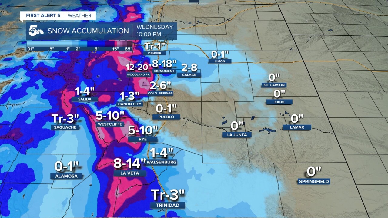
Snow totals are going to be broad, but we could see a general 2 to 6 inches across central Colorado Springs with 6 to 12 inches north around Monument, and even more snow up into Teller County. The roads will start wet Tuesday evening but they should be snow-covered for the Wednesday morning commute. The largest impact will occur in towns over 7,000 feet due to freezing overnight temperatures.
Elevations lower than 6,200 feet, like Pueblo and Denver, could see some snow Wednesday morning, but most of the storm will fall as rain.
Thursday will be dry with a quick shot of rain/snow Friday morning.
____
Curious about the First Alert 5 Weather Storm Impact Scale? Check out our cheatsheet explainer.
Watch KOAA News5 on your time, anytime with our free streaming app available for your Roku, FireTV, AppleTV and Android TV. Just search KOAA News5, download and start watching.
