

Tonight's Forecast:
More clouds will move in from the west. Southwesterly winds are slowly bringing more moisture to the mountains and some snow showers will pop up in the mountains overnight. Accumulations will be very limited. Clouds will keep temperature from getting as cold as Saturday morning, but lows will still be chilly. Winds will pick up for the higher terrain early tomorrow morning, especially for places closer to the Ramparts.
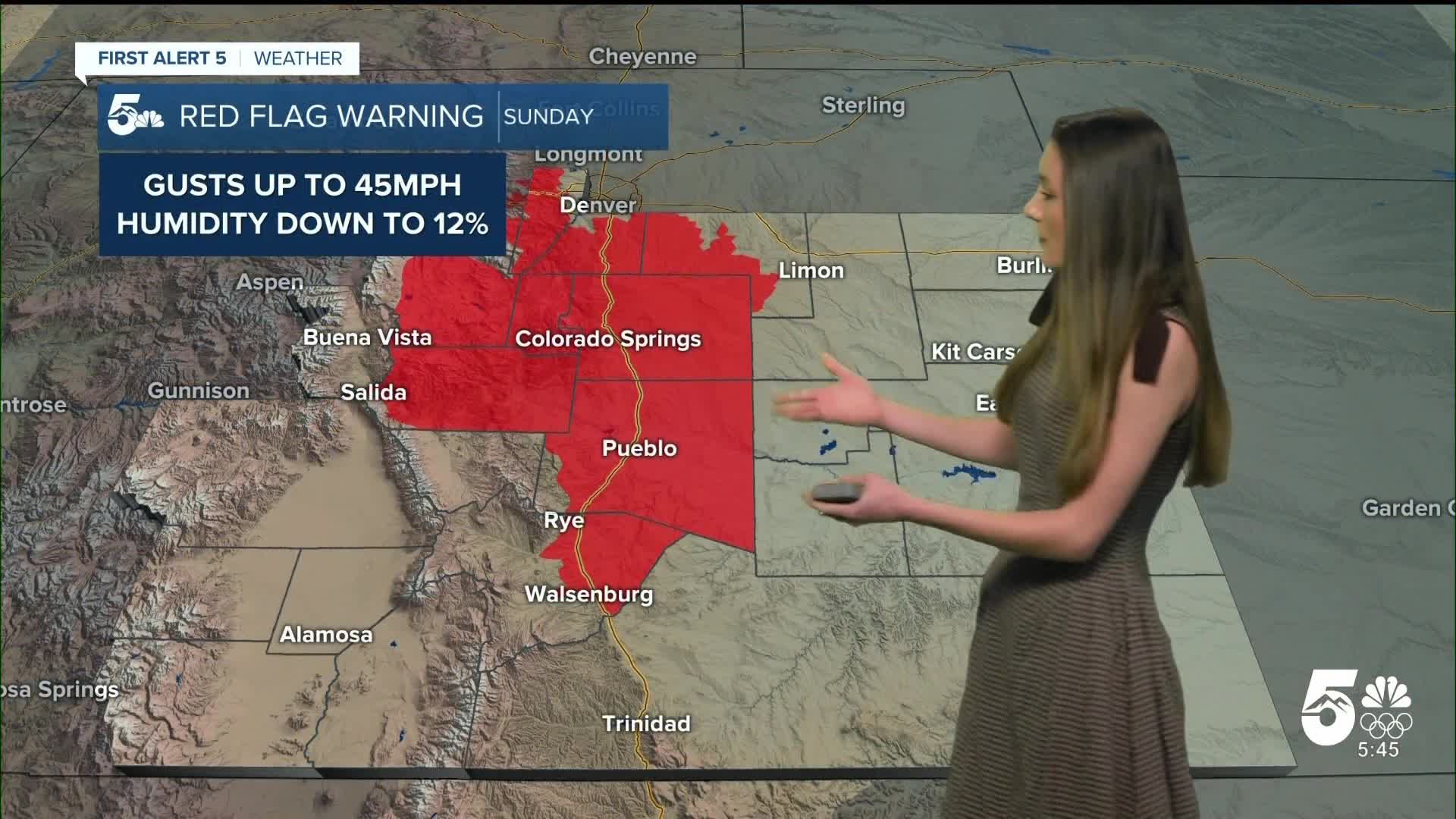
Colorado Springs forecast: Low: 36; High: 66;
Colorado Springs will get breezy tomorrow and this will begin in the morning. Southwesterly winds will keep temperatures well above average. Highs will make it into the mid-60s. Red Flag Warnings will be in place beginning at 10AM due to these windy and dry conditions.
Pueblo forecast: Low: 32; High: 70;
Pueblo will have morning temperatures right at freezing. These temperatures won't last long due to southwesterly winds helping to warm things up. Highs by the afternoon will be in the 70s. Red Flag Warnings are in place for Pueblo county starting at 10AM. Avoid creating any sparks. Fires that start in these conditions can spread quickly.
Canon City forecast: Low: 38; High: 68;
Clouds will move in overnight and keep temperatures from getting too cold overnight. These temperatures will still be chilly though. Canon City will have some gusty winds tomorrow with the highest gusts closer to 45mph. These winds will also help to warm the area up. Afternoon highs will reach the upper 60s.
Woodland Park forecast: Low: 32; High: 58;
Woodland Park will wake up to temperatures in the lower 30s. Red Flag Warnings will begin for Teller county at 10AM. Winds will reach 40mph at times. Conditions will be dry with humidity values getting into the teens. Afternoon highs will be in the upper 50s.
Tri-Lakes forecast: Low: 38; High: 63;
Monument will have morning lows in the upper 30s. Winds will pick up around 10AM and this is also when Red Flag Warnings will go into effect. Afternoon highs will make it into the lower 60s.
Plains forecast: Low: 30s; High: 70s;
The plains will be nice and warm tomorrow. Winds won't quite reach red flag warning criteria, but these southwesterly winds will bump up the temperatures by a few degrees. Highs will make it into the 70s.
Walsenburg and Trinidad forecast: Low: 40/37; High: 65/69;
The southern I-25 corridor will have a few red flag warnings in place across Huerfano county, but Las Animas county will still be in a fire weather watch. Winds in this area won't reach the criteria for a red flag warning to be issued. Highs will make it into the mid-to-upper 60s.
Mountains forecast: Low: 30s; High: 50s;
The mountains will have a few isolated snow showers overnight, but there won't be much in terms of accumulations. Overnight lows will be in the 30s and by the afternoon highs will be in the 50s.
Extended outlook forecast:
The start of the week will have gusty conditions continue. Partly cloudy to mostly clear conditions over this time period. There will be a shakeup in the forecast around Thursday. Cold air will move in from the north, but the models are still uncertain on timing, pace, and how cold these temperatures will be. The forecast is likely going to change between now and then, but just be prepared for colder temperatures. Friday's highs will continue to dip, and will be the coldest day of the week.
____
Curious about the First Alert 5 Weather Storm Impact Scale? Check out our cheatsheet explainer.
Watch KOAA News5 on your time, anytime with our free streaming app available for your Roku, FireTV, AppleTV and Android TV. Just search KOAA News5, download and start watching.
