

Tonight's Forecast:
A couple of strong to severe storms will be possible across southeastern Colorado. There will likely be another round of showers and storms that will push onto the I-25 corridor and the Pikes Peak Region around 7/8PM. Some showers and storms will linger into the overnight hours.
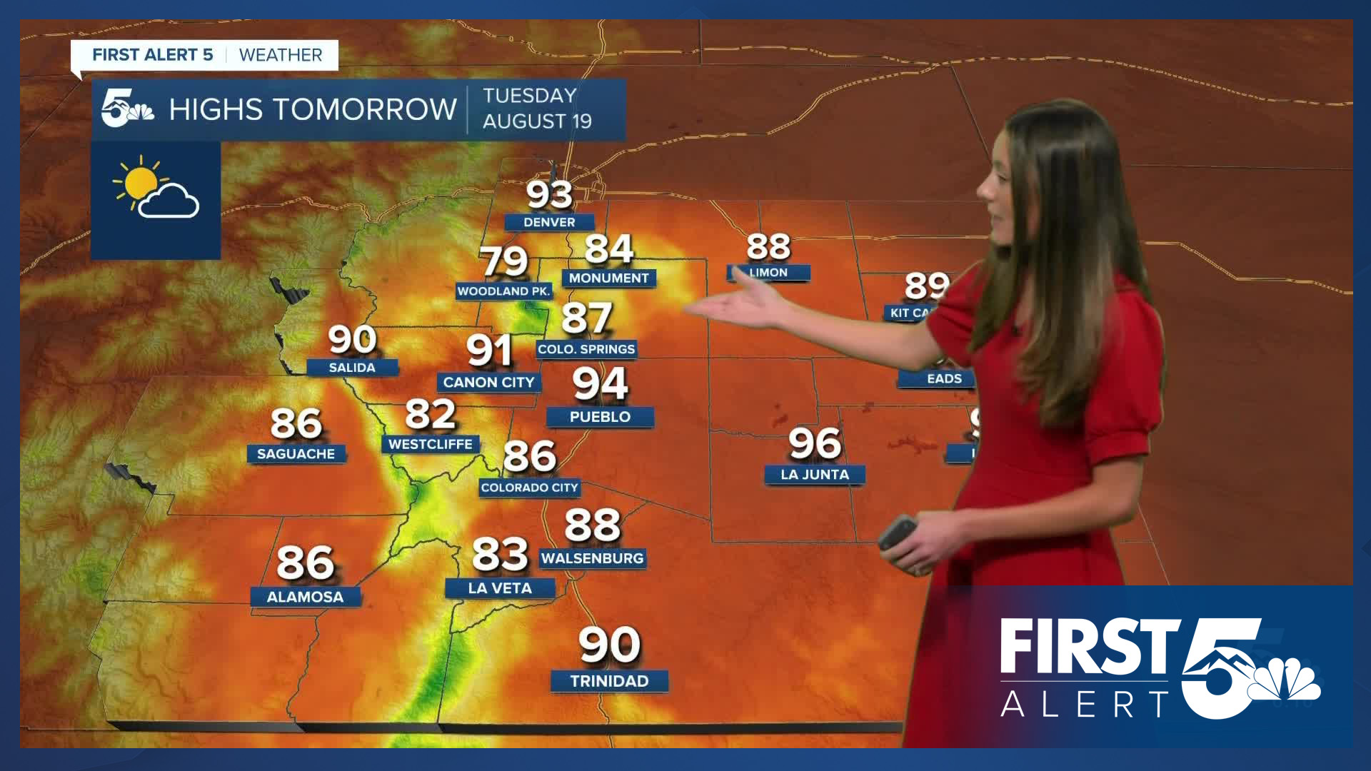
For Tuesday, rain chances will be limited due to the building high-pressure system. Temperatures will remain steady in the upper 80s and lower 90s across the area. The coolest temperatures will be in the higher terrain with highs in the 70s and 80s.
Colorado Springs forecast: Low: 57; High: 87;
Colorado Springs will have a few showers and storms Monday evening and into the overnight hours. Things will clear out by the morning. Overnight lows will be in the upper-50s. For Tuesday, temperatures will be in the upper 80s. Storm coverage will decrease though there is still a chance for a spot shower or two.
Pueblo forecast: Low: 61; High: 94;
Some showers are still possible in the Pueblo area Monday evening, but will clear out overnight. Pueblo will start to dry off going into Tuesday. Temperatures will remain steady in the mid-90s.
Canon City forecast: Low: 62; High: 91;
Canon City will have a few spotty showers in the area Monday evening. There will be some leftover clouds that will last through the early morning hours. Overnight lows will be in the lower 60s. Highs Tuesday afternoon will be in the lower 90s.
Woodland Park forecast: Low: 48; High: 79;
Woodland Park will continue with some isolated storm chances going into Tuesday. Overnight lows will be chilly in the upper 40s. By the afternoon temperatures will have risen into the upper 70s.
Tri-Lakes forecast: Low: 56; High: 84;
The Monument area will have a few lingering showers overnight, but by the morning this will have cleared out. Morning lows will be in the mid-50s, and afternoon highs will be in the mid-80s. There is a possibility for a rogue shower, but most of the area will stay dry.
Plains forecast: Low: 60s; High: 90s;
The Plains will continue with the severe threat until 10PM when the severe thunderstorm watch ends for Kiowa and Cheyenne counties. There will still be some storm activity overnight and into the early morning hours on Tuesday. Overnight lows will be in the 60s and Tuesday's highs will be in the 90s.
Walsenburg and Trinidad forecast: Low: 59/56; High: 88/90;
The southern I-25 corridor will clear out overnight, except for a few clouds. Temperatures overnight will dip into the mid-to-upper 50s. Highs going into Tuesday afternoon will be in the upper 80s/lower 90s. There will be a decrease in rain chances from Monday.
Mountains forecast: Low: 40s & 50s; High: 80s;
The high country will have some clouds overnight, but by morning they will clear out. The best chance for storms and showers will be for the higher terrain with the leftover moisture from Monday. Highs will be in the 80s across the area.
Extended outlook forecast:
Looking ahead, conditions will continue to dry out on Wednesday. A high-pressure system will continue to build over the four corners region helping to keep things hot and dry through Thursday. The hottest day of the week will be on Thursday. Monsoon moisture returns at the end of the week and widespread rain will be possible throughout the upcoming weekend.
____
Curious about the First Alert 5 Weather Storm Impact Scale? Check out our cheatsheet explainer.
Watch KOAA News5 on your time, anytime with our free streaming app available for your Roku, FireTV, AppleTV and Android TV. Just search KOAA News5, download and start watching.
