


Today’s Forecast:
We're looking at more snow across southern Colorado, and this time it'll favor areas south of the Pikes Peak Region. Snowfall will begin this afternoon in and around Highway 50 first, spreading through the rest of the region through the overnight hours. The winds will get stronger later today in the lower elevations out of the north, helping to push extra cold air into the region. We'll see snowfall stop early Thursday morning, but we're still expecting plenty of slick commutes.

COLORADO SPRINGS: High: 28; Low: 12. North winds will increase this afternoon, and very well could kill snow totals over the city! Despite the drying north wind, we still think through the evening we'll get snow totals ranging from a dusting to 3 inches across town. We're more likely to get closer to that 2 or 3 inch mark south of Garden of the Gods road.
WOODLAND PARK: High: 26; Low: 8. North winds won't impact Teller County and Woodland Park quite as much, but colder air should lead to stackable flakes and land us somewhere between 1 to 4 inches.
TRI-LAKES: High: 20s; Low: <10. Strong northerly winds and cold air will make snowfall late today and tonight stack up between 1 to 4 inches through the Tri Lakes area. We'll see very cold air, and any late drives home from Denver tonight could be slick.
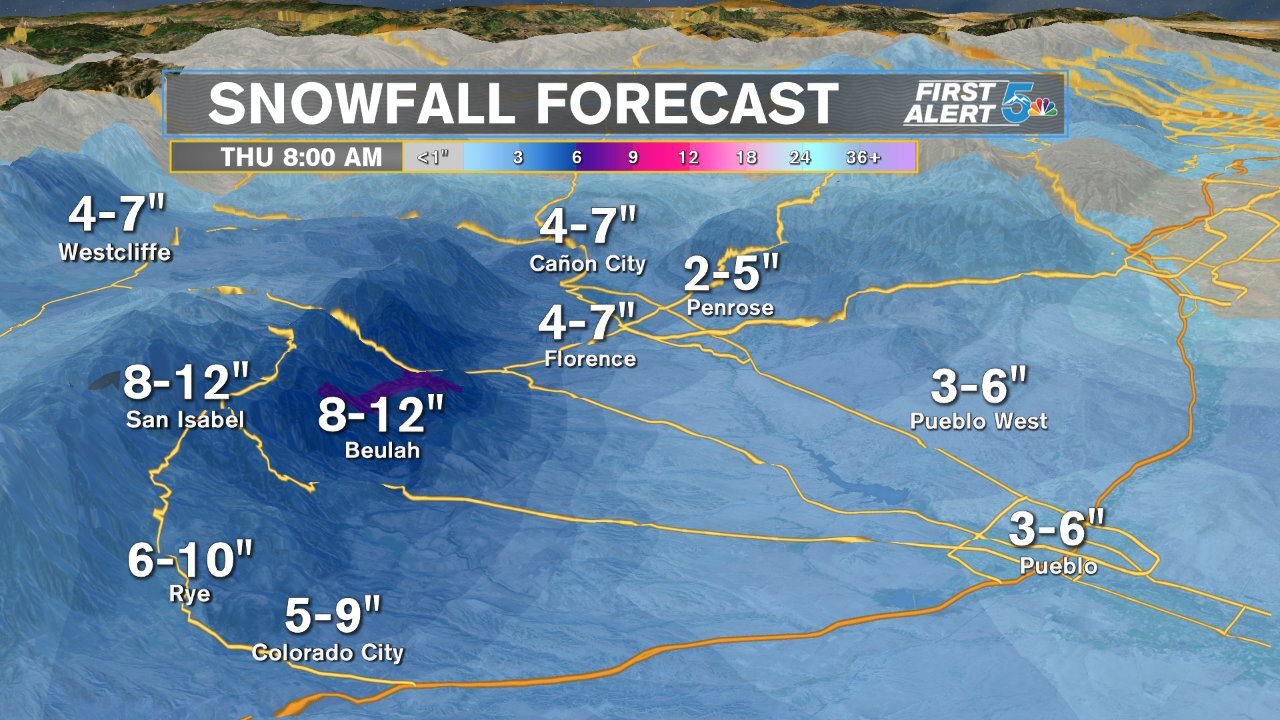
PUEBLO: High: 34; Low: 14. Heavy snow with strong winds are expected to impact Pueblo starting in the afternoon, and continuing through the overnight hours. Snow will stack up very well this evening and we should see anywhere between 3 to 6 inches by early Thursday morning.
CANON CITY: High: 34; Low: 19. Heavy snow is expected from the afternoon through the early morning hours of Thursday, but with not with as much wind as Pueblo. We'll see pretty heavy snow accumulations by Thursday morning with most of town seeing somewhere between 4 to 7 inches.

WALSENBURG/TRINIDAD: High: 30/40s; Low: 10s. Strong gusty winds will push temperatures out of the 30s and 40s through Walsenburg and Trinidad, with heavy snow stacking up from the late day hours through early Thursday morning. Heavier snowfall will happen out west through La Veta and La Veta Pass overnight, landing the mountain towns with 6 to 10 inches. Walsenburg and Aguilar will cool quickly tonight and that will allow us to see 3 to 6 inches of snow easier. Trinidad could be a busted forecast since we'll be in the 40s during the daytime, so we'll need to cool temperatures quickly if we're going to see 4 to 7 inches of snow.
PLAINS: High: 30s; Low: 10s. Areas east of I-25 in the plains will see the heaviest snowfall in and around the highway 50 towns. Strong northerly winds will reduce visibility and quickly drop temperatures through the afternoon when snowfall begins to fall. We'll see snow wrap up quickly overnight with most areas seeing between 3 to 6 inches by Thursday morning.
Extended Outlook:
We'll bring the sunshine out Thursday morning and get some snow melt into the afternoon, despite most of the region staying at or below freezing. Warmer air is expected on Friday with 50s back in the forecast by Saturday. The next snow chance now looks to fall on Sunday, but likely as a rain to snow mixture at first due to warmer daytime temperatures.
