

Tonight's Forecast:
Conditions will continue to be calm and quiet this evening. If hyou are headed to the balloon glow at Memorial Park later on sunset will be at 7:30PM, and light will last about an hour afterwards.
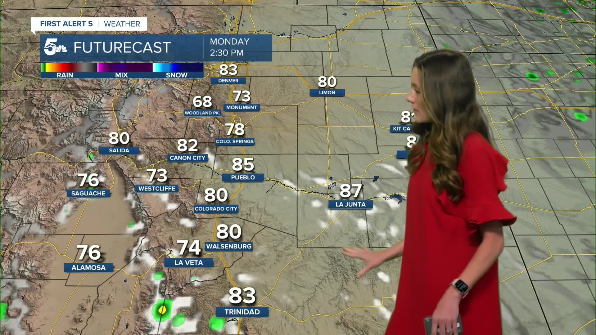
Labor Day looks beautiful with bright and sunny conditions which will make it a perfect day to get outside. Highs will be in the 70s and 80s across southern Colorado.
Colorado Springs forecast: Low: 52; High: 80;
The balloon glow later this evening will have temperatures in the 70s through 8PM, and 60s onward. Overnight lows will be in the lower 50s in the Pikes Peak Region. Highs on Labor Day will be in the lower 80s by the late afternoon. Clear conditions will last throughout the day and winds will be between 5-15mph.
Pueblo forecast: Low: 54; High: 86;
Pueblo will start to cool into the 60s by 8/9PM this evening. Overnight lows will dip into the mid-50s. By the early morning hours on Labor Day, clouds will make their way out of the area and we will start the day with plenty of sunshine. Temperatures in the afternoon will rise into the mid-80s.
Canon City forecast: Low: 57; High: 84;
Canon City will have a spot shower possible this evening, but most areas will stay dry. Temperatures will drop into the upper 50s by the early morning hours of Monday. Afternoon highs will be in the mid-80s. Mostly clear conditions will be present throughout the day.
Woodland Park forecast: Low: 42; High: 72;
Woodland Park will have overnight lows in the lower 40s. Temperatures will warm throughout the day and by the afternoon highs will be in the lower 70s. A few clouds will move into the area by the late afternoon. Rain chances won't pick up until Tuesday.
Tri-Lakes forecast: Low: 49; High: 76;
The Monument area will continue with calm and quiet conditions into Labor Day. It will be a nice day to get outside, and enjoy the weather. By the afternoon temperatures will be in the mid-70s with clear conditions.
Plains forecast: Low: 50s; High: 80s;
The plains will have a few clouds move into the area by Monday afternoon, but no rain is expected. Temperatures will rise into the lower-to-mid-80s later in the afternoon.
Walsenburg and Trinidad forecast: Low: 53/52; High: 80/83;
The southern I-25 corridor has the best chances for a spotty shower on Monday. This will mainly be in the afternoon, and these showers aren't expected to be strong. Temperatures will be in the lower 80s in the afternoon with more clouds moving into the area later on.
Mountains forecast: Low: 40s; High: 70s;
The mountains will have a few showers possible closer to La Veta Pass, and more clouds will filter in throughout the day. By the afternoon, temperatures will have risen into the 70s across the higher terrain. Rain chances will be limited, but a spotty shower will still be possible.
Extended outlook forecast:
Looking beyond Monday, rain chances start to pick back up for the higher terrain with some leftover moisture. A weak cold front will push into Colorado on Wednesday, but temperatures won't be affected too much. Rain chances will go up slightly for I-25 and a spotty shower is possible. Another cold front will push through on Friday and this one will be a little stronger with rain chances increasing into the weekend.
____
Curious about the First Alert 5 Weather Storm Impact Scale? Check out our cheatsheet explainer.
Watch KOAA News5 on your time, anytime with our free streaming app available for your Roku, FireTV, AppleTV and Android TV. Just search KOAA News5, download and start watching.
