

Tonight's Forecast:
Temperatures will be dangerously cold tonight, dipping into the single digits. Wind chill will be even colder with some areas feeling like they are below zero. Clouds will clear overnight and help for temperatures to cool. By the early morning hours of Saturday, more clouds will move in, but the sun will still be peaking through.
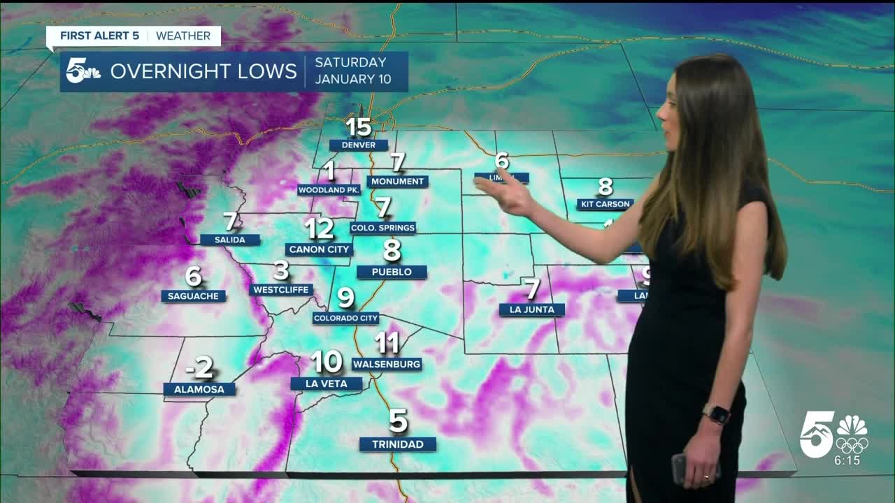
Colorado Springs forecast: Low: 7; High: 40;
Colorado Springs will have temperatures dip into the single digits overnight. There will be a few clouds in the area tomorrow. There will be continued melting, but shady areas may have a few slick spots. Afternoon highs will get into the lower 40s.
Pueblo forecast: Low: 8; High: 41;
Pueblo will dip to 8 degrees overnight with some other areas even colder. Roadways will refreeze overnight, so any early morning commutes will take more time. Sunshine throughout the day will help to melt these roads again. It will take a few days for areas in the shade to melt completely.
Canon City forecast: Low: 12; High: 44;
Canon City will have overnight lows in the teens. A few clouds will move in by the morning, but there will still be some sunshine. Roads will still be wet and icy in some areas. Afternoon temperatures will help to melt some of this ice and snow. Highs will be in the mid-40s.
Woodland Park forecast: Low: 1; High: 36;
Woodland Park will have an overnight low of only 1 degree. This will only be an issue in the morning, and temperatures will warm back to above freezing. Highs will be in the mid-30s. It will still be a chilly day and layers will be needed.
Tri-Lakes forecast: Low: 7; High: 40;
Monument will have overnight lows around 7 degrees. There will be more clouds that move in, but temperatures in the afternoon will still get close to 40 degrees. Be cautious of shady areas where there could still be some lingering snow and ice.
Plains forecast: Low: Single Digits; High: 40s;
The eastern plains will have snow showers warp up overnight, but clouds will remain. Overnight lows will dip into the single digits. Once the sun rises tomorrow, temperatures will warm into the 20s. Highs in the afternoon will get into the 40s.
Walsenburg and Trinidad forecast: Low: 9/3; High: 39/42;
The southern portion of I-25 will have icy and snowy roads overnight. With temperatures dipping into the single digits things will get dicey overnight. The morning commute will need to be taken slow and budget in extra time.
Mountains forecast: Low: Single Digits; High: 30s;
The mountains will have overnight lows in the single digits. Cold temperatures will linger into the morning. Highs will be in the 30s.
Extended outlook forecast:
An upper-level ridge will build back across Colorado, and temperatures will warm each day. 40s will remain through the weekend. 50s return by the start of the week. The next few days will be calm weather wise, and we will stay dry.
____
Curious about the First Alert 5 Weather Storm Impact Scale? Check out our cheatsheet explainer.
Watch KOAA News5 on your time, anytime with our free streaming app available for your Roku, FireTV, AppleTV and Android TV. Just search KOAA News5, download and start watching.
