

Tonight's Forecast:
Tonight, clouds will clear out and this will allow for temperatures to reach the teens. These temperatures will last through the morning, so a jacket and some layers will be needed.
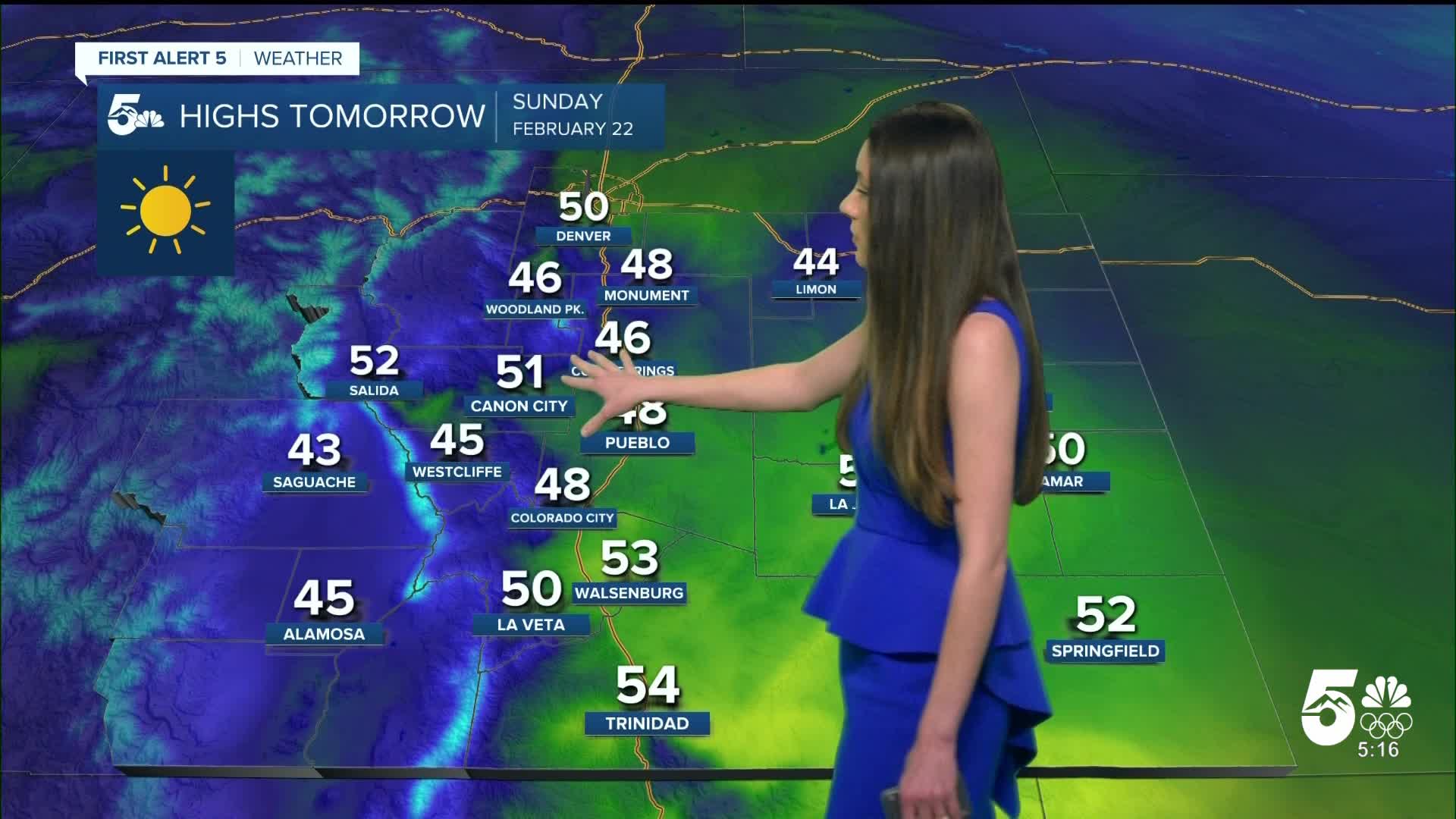
Colorado Springs forecast: Low: 16; High: 46;
Sunday's temperatures will still be chilly. You will want to wear a jacket and a hat throughout the day. Highs will only make it into the mid-40s. There will be very similar conditions to Saturday. Clouds will clear out and there will be plenty of sunshine.
Pueblo forecast: Low: 13; High: 48;
Pueblo will have overnight temperatures reach the teens. By the afternoon, these temperatures will warm to the upper 40s. Skies will remain clear during the day.
Canon City forecast: Low: 17; High: 51;
Canon City will wake up to temperatures in the upper teens. Highs will be similar to Saturday and get into the lower 50s. Winds will stay light and there will be plenty of sun.
Woodland Park forecast: Low: 13; High: 46;
Woodland Park will have temperatures get into the teens overnight. Conditions will be very similar to the rest of the Pikes Peak Region. Highs in the afternoon will make it into the mid-40s. Winds will also stay light between 5-10mph.
Tri-Lakes forecast: Low: 14; High: 48;
Overnight lows will be chilly, getting into the teens. Waking up and getting out the door, you outfit will need some layers. Headed into the afternoon, temperatures will be in the upper 40s. Luckily, winds will be on the lighter side so the feels like temperature will be close to that air temp.
Plains forecast: Low: Teens; High: 40s & 50s;
The eastern plains have a cold night ahead as well with lows reaching the teens. The sun will help to heat temperatures up into the 50s for a few areas in the Arkansas River Basin, but that cold air mass is still going to linger. These temperatures are very seasonable for this time of year.
Walsenburg and Trinidad forecast: Low: 16/17; High: 53/54;
The southern portion of I-25 will have overnight lows dip into the teens. Clear conditions will help temperatures to reach this point, but on the flip side this allows for sunshine during the day. Highs will heat into the lower to mid 50s.
Mountains forecast: Low: Teens; High: 40s & 50s;
The mountains and higher terrain will also dip into the teens overnight. Not too many clouds during the day and highs will reach the 40s and 50s. Winds will remain light during the day.
Extended outlook forecast:
Looking ahead, these cold temperatures won't stick around for too long. Highs by Monday will be in the 60s. This is very much above normal for this time of year. This is set to continue throughout the week. Windy conditions return and Wednesday looks to have the biggest impacts. There is a small chance for some moisture in this time frame, but likely we will just see that in the form of clouds.
____
Curious about the First Alert 5 Weather Storm Impact Scale? Check out our cheatsheet explainer.
Watch KOAA News5 on your time, anytime with our free streaming app available for your Roku, FireTV, AppleTV and Android TV. Just search KOAA News5, download and start watching.
