



Tonight's Forecast:
Tonight, temperatures will dip into the 40s and 50s for I-25. 50s are expected four counties further east. In the mountains, temperatures will dip into the 30s and 40s. Clouds will clear out and winds will be blowing out of the northwest between 5 and 10mph.
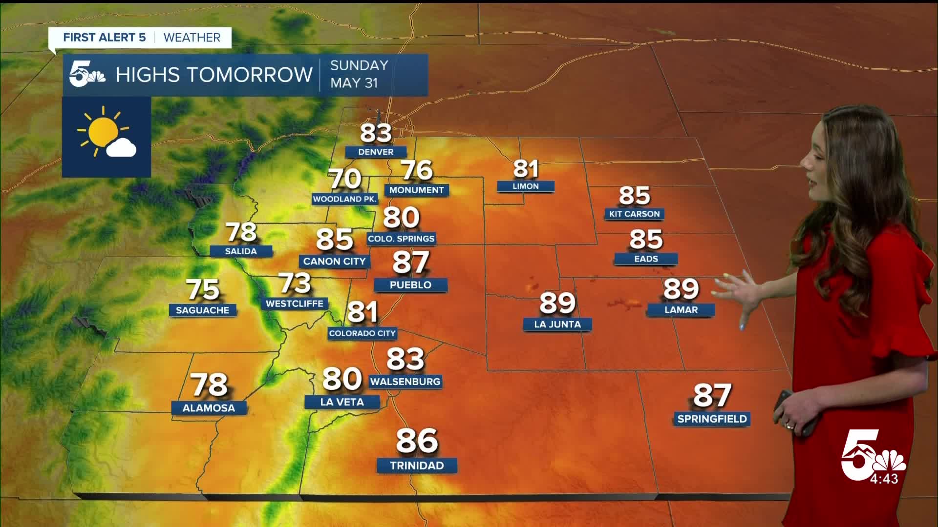
Colorado Springs forecast: Low: 46; High: 80;
For Sunday, morning temperatures will start off in the mid-40s, but once the sun rises these temperatures will warm quickly. By the afternoon, temperatures will be in the upper 70s and lower 80s. More clouds will move in throughout the day.
Pueblo forecast: Low: 48; High: 87;
Pueblo will start the day off with temperatures in the upper 40s. Even with a cooler start, temperatures will still be warm by the afternoon with highs getting into the upper 80s. Winds will be coming out of the west between 5-15mph. There will be some more clouds that move in throughout the day.
Canon City forecast: Low: 50; High: 85;
Canon City will have overnight lows in the lower 50s. The day will start off sunny and it won't be until the afternoon that we will have some clouds push into the area. Afternoon highs will be in the mid-80s. Winds will be coming out of the west to start off the day between 5-10mph.
Woodland Park forecast: Low: 39; High: 70;
Woodland Park will have lows in the upper 30s. By the late morning, temperatures will be in the 60s. Clouds will build during the day, but rain chances remain low. Afternoon highs will be in the 70s.
Tri-Lakes forecast: Low: 44; High: 76;
Monument and the surrounding areas will have morning temperatures in the mid-to-lower 40s. Even with a chilly start, afternoon temperatures will make it into the mid-70s.
Plains forecast: Low: 40s & 50s; High: 80s;
The eastern plains will stay clear overnight, and lows will be in the 40s and 50s. Sunny skies will remain throughout the day other that a few clouds in the afternoon. Temperatures will be warm with highs getting into the 80s. Winds will be coming out of the west between 5 and 10mph.
Walsenburg and Trinidad forecast: Low: 48/45; High: 83/86;
The southern I-25 corridor will have overnight lows in the 40s. There will be mostly clear skies during the day. Afternoon highs will be in the lower-to-mid 80s. Winds will be coming out of the west between 5-10mph.
Mountains forecast: Low: 30s & 40s; High: 70s;
The mountains will have morning temperatures in the 30s and 40s. There is a chance for a high-based shower or two over the central mountains. This may create some gusty conditions. Highs will be in the 70s.
Extended outlook forecast:
Looking ahead, Monday will be active. The Storm Prediction Center has a Slight risk (2/5) for eastern Colorado. Large hail, gusty winds, and lightning will be the main threats. Along I-25 there is a Marginal Risk (1/5), and severe weather is still a possibility. Storms will start in the afternoon and last into the evening.
Tuesday and Wednesday will still have a chance for an afternoon thunderstorm. It's that time of year where afternoon thunderstorms are almost a daily occurrence. Thursday and Friday looks a little more dry, but don't be surprised if there's still a shower or two in the afternoon.
____
Curious about the First Alert 5 Weather Storm Impact Scale? Check out our cheatsheet explainer.
Watch KOAA News5 on your time, anytime with our free streaming app available for your Roku, FireTV, AppleTV and Android TV. Just search KOAA News5, download and start watching.
