

Today’s Forecast:
Snow in the Pikes Peak Region from last night will move northeast out of the way through the early morning hours, but we will have areas of fog develop behind the snow.
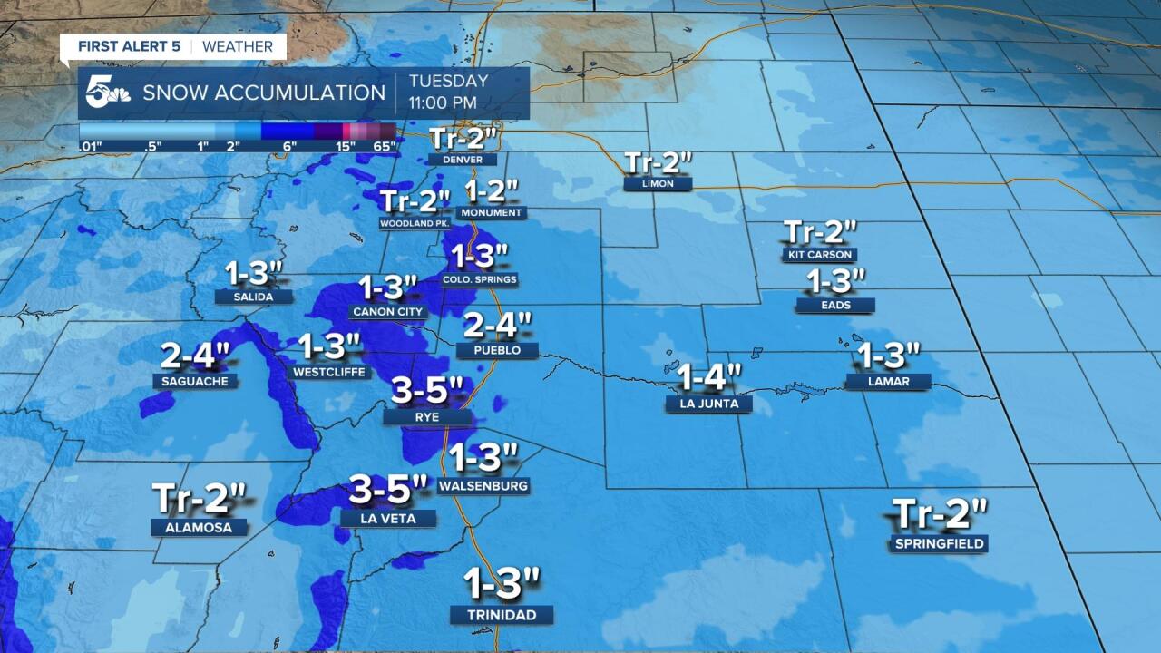
More snow will move in from the southwest, spreading first through the southern mountains and then up into the Pueblo and Pikes Peak Region by 7 to 8 am. This second wave of snow could dump another 1 to 3 inches in the Pikes Peak Region, and another 2 to 4 inches from Pueblo down to Trinidad.
Snow will end tonight and dangerously cold temperatures will move in by early Wednesday morning. Lows are forecast to be in the single digits and a few negatives.
COLORADO SPRINGS: High: 23; Low: 6. Cold with more snow today from the morning and mostly dry skies in the afternoon. A few wrap around flurries are possible this evening, but with little to no extra accumulation. 1 to 3 inches is possible across Colorado Springs, but the heavier snow will likely favor the south half of town.
PUEBLO: High: 25; Low: 3. Cold and snowy today with snow in the morning and mostly dry skies in the afternoon. We could see a few wrap around flurries late today and this evening, but most of our 2-4 inches today will fall in the morning.
CANON CITY: High: 24; Low: 9. Cold and snowy in the morning with a few wrap around snow showers or flurries this evening. We could see 1 to 3 inches this morning with dangerously cold temperatures overnight.
WOODLAND PARK: High: 20; Low: 6. Cold with light snow showers this morning and 1 to 2 inches of snow possible before mostly dry skies take over this afternoon. We could see wrap around flurries this evening but with little to no extra accumulation.
TRI-LAKES: High: 10s; Low: <10. Cold with snow showers in the morning and 1-2 inches of snow possible. We will be dry this afternoon with light flurries possible this evening and dangerously cold temperatures tonight.
PLAINS: High: 20s; Low: <10. Snow showers through the morning and early afternoon with a general 1 to 3 inches possible in the morning. We should be mostly dry tonight and just really cold.
WALSENBURG/TRINIDAD: High: 20s; Low: <10. Snow showers in the morning with slick I-25 drives and a few wrap around flurries in the evening. Snow totals should stay at or under 3 inches today.
MOUNTAINS: High: 20s; Low: <10. More snow today, especially for the Sangre De Cristo and Wet Mountains. Most of this snow will fall this morning and early this afternoon with just a few wrap around flurries on the Front Range. We should see around 3-5 around La Veta and Cuchara and around 3-6 inches from Rye to San Isabel. It'll be incredibly cold tonight.
Extended Outlook:
We'll be warmer and dry on Wednesday with sunshine melting snow that falls today. Temperatures should rebound nicely into the 50s and even a few 60s by Friday with dry skies. We should stay dry this weekend and just be a little windy on Saturday from a cool front.
