

Tonight's Forecast:
A few showers and thunderstorms will continue through the evening. Some clouds will stick around and it will be somewhat of a gloomy evening. Overnight lows will drop into the 50s for the higher terrain and 60s closer to I-25 and the plains.
Tomorrow, there will be a chance for more afternoon and evening showers and thunderstorms. Some of these may produce some heavy rain, gusty winds and lightning. Showers and thunderstorms will start in the mountains and become more widespread throughout the day, eventually pushing onto the I-25 corridor.
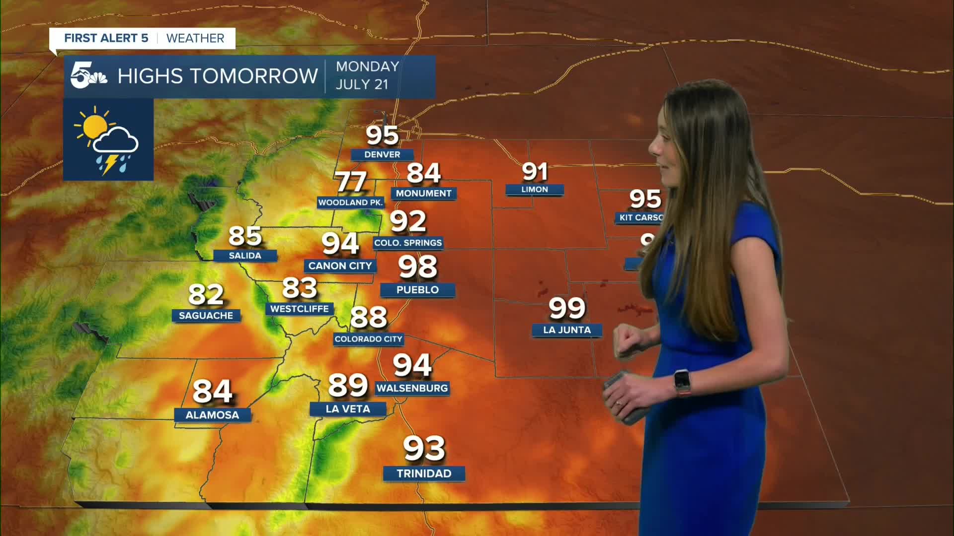
Colorado Springs forecast: Low: 62; High: 92;
There will be hit or miss showers Sunday evening for Colorado Springs. Overnight lows will drop into the lower 60s. Monday morning will have partly cloudy conditions and there will be increasing cloud cover throughout the day. Afternoon thunderstorms will start around 2/3PM, but will pick up in intensity closer to dinnertime.
Pueblo forecast: Low: 64; High: 98;
Pueblo will have a small chance for showers and thunderstorms this afternoon and evening, but most of these storms will fizzle out pretty quickly. Overnight lows will drop into the mid-60s. Highs for Monday will be hot in the upper 90s. There will be a 20% chance for showers and thunderstorms for Monday.
Canon City forecast: Low: 65; High: 94;
Canon City will hold onto the cloud cover overnight and this will help to keep overnight lows on the warmer side. Highs on Monday will be hot in the mid-to-lower 90s. There will be another chance for afternoon thunderstorms. Monsoon moisture won't begin to bring in heavy rain until the middle of the week.
Woodland Park forecast: Low: 54; High: 77;
Woodland Park will have the best chances for rain and thunderstorms. Some of these showers and thunderstorms will bring heavy rain and gusty winds. Highs for Monday afternoon will be in the upper 70s.
Tri-Lakes forecast: Low: 62; High: 84;
The Monument area will have some hit or miss showers and thunderstorms Sunday evening. Clouds will remain overnight and into Monday morning. Overnight lows will be on the warmer side in the lower 60s. Highs on Monday will reach the mid-80s. Rain chances will return to the area Monday afternoon.
Plains forecast: Low: 60s; High: 90s & 100s;
The Plains will have a few scattered thunderstorms this evening. A few of these storms may become severe. Going into Monday, rain chances pick up again during the afternoon and evening. Highs will be warm in the 90s and 100s.
Walsenburg and Trinidad forecast: Low: 61; High: 94/93;
The southern I-25 corridor will have temperatures in the 60s overnight. Some clouds will liner into Monday morning. The chance for afternoon thunderstorms and rain will pick up again on Monday.
Mountains forecast: Low: 50s; High: 80s;
The mountains will have widespread showers and thunderstorms on Monday. These storms will produce some gusty winds and lightning. There may also be some heavy rainfall with a few of these showers and thunderstorms. Highs will be in the 80s.
Extended outlook forecast:
Monsoon moisture is expected to pick back up this week. This will increase rain chances during the middle of the week. There is some concern with flooding given how much rain has already fallen. There is a marginal risk for excessive rain each day this week. Before heading out, check to see if there are any flash flood warnings in your area.
____
Curious about the First Alert 5 Weather Storm Impact Scale? Check out our cheatsheet explainer.
Watch KOAA News5 on your time, anytime with our free streaming app available for your Roku, FireTV, AppleTV and Android TV. Just search KOAA News5, download and start watching.
