

Tonight's Forecast:
Rain will continue for the I-25 corridor into the overnight hours. Rain will be heavy at times with some lightning, so if you are outdoors make sure you have a shelter nearby. Overnight lows will dip into the 50s and 60s.
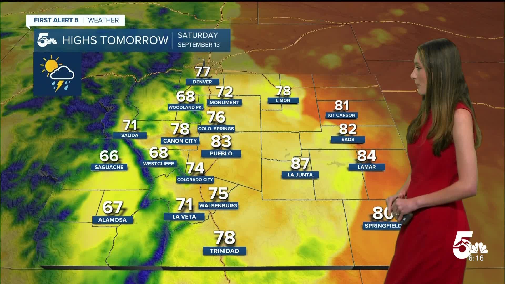
Colorado Springs forecast: Low: 51; High: 76;
Saturday morning will have some clouds with the leftover moisture, and by the time we get into the afternoon the rain will pick back up as well. Some storms that move into the area have the potential to be severe. Highs will get into the mid-70s.
Pueblo forecast: Low: 57; High: 83;
Pueblo will have morning temperatures in the upper 50s. Rain picks back up in the afternoon and evening. This will clear out overnight. Highs will be in the lower 80s.
Canon City forecast: Low: 56; High: 78;
Canon City will also have some lingering moisture which will lead to some storms in the afternoon on Saturday. Highs will be in the upper 70s. Sunday is expected to be much drier.
Woodland Park forecast: Low: 42; High: 68;
Woodland Park will have temperatures in the lower 40s Saturday morning. Going into the afternoon highs will be in the upper 60s. The chance of rain will pick up in the afternoon and will last through dinner time.
Tri-Lakes forecast: Low: 48; High: 72;
The Monument area will have overnight lows in the upper 40s. Temperatures in the afternoon will rise into the lower 70. Winds will be gusty at times with the storms moving through in the afternoon. Rain chances will linger into the afternoon.
Plains forecast: Low: 60s; High: 80s;
The plains will have a few overnight showers and temperatures will drop into the 60s. The chance of rain will linger into the afternoon on Saturday, but conditions will clear on Sunday.
Walsenburg and Trinidad forecast: Low: 54; High: 75/78;
The southern I-25 corridor will have morning lows in the mid-50s. Highs Saturday afternoon will be in the mid to upper 70s. Winds will also be gusty at times from some of the storms moving through. Some storms will have the potential to become severe.
Mountains forecast: Low: 40s; High: 60s & 70s;
The mountains will have the best chances for flash flooding and a flood watch is set to expire at midnight tonight. Going into Saturday the chance of rain will linger. Rain will get heavy at times too. Highs will be in the 60s and 70s.
Extended outlook forecast:
Looking beyond Saturday, conditions will begin to dry out. The start of the work week looks great with temperatures staying in the 70s and 80s. Our next cold front arrives Wednesday and that also brings the next chance for rain.
____
Curious about the First Alert 5 Weather Storm Impact Scale? Check out our cheatsheet explainer.
Watch KOAA News5 on your time, anytime with our free streaming app available for your Roku, FireTV, AppleTV and Android TV. Just search KOAA News5, download and start watching.
