


Today’s Forecast:
Light snow overnight dropped about 1 to 2 inches in northern El Paso County and Teller counties last night with around 3 to 4 inches through the Wet Mountain Valley!
Today we'll be dry through the afternoon, but light rain to snow showers will return tonight before heavier periods of rain and snow Thursday afternoon through Friday morning.
Any snow we get tonight should stay at or below 1 inch and mostly through the grassy areas of El Paso and Teller counties. There could be areas of drizzle late tonight along and north of Highway 50.
COLORADO SPRINGS: High: 48; Low: 29. Mostly cloudy skies today with dry, breezy, and chilly daytime conditions. We'll see light snow showers move in tonight, but snow accumulations should range from zero to less than one inch. The pavement will be fine overnight as any snow would only accumulate in the grass.
PUEBLO: High: 55; Low: 34. Mostly cloudy, dry, and breezy at times today with cool afternoon conditions. We could see a few showers overnight with areas of drizzle by tomorrow morning.
CANON CITY: High: 53; Low: 35. Mostly cloudy, windy at times, and dry today with coll afternoon temperatures. Light rain to drizzle is possible overnight through early Thursday morning.
WOODLAND PARK: High: 45; Low: 28. Mostly cloudy and windy at times today with chilly afternoon temperatures. Light snow showers are expected tonight but with accumulations at or under one in the grassy through by Thursday morning.
TRI-LAKES: High: 40s; Low: 30s. Mostly cloudy, breezy, and cold in the afternoon with light snow showers overnight into Thursday morning. Any snow accumulation will be in the grassy areas and will likely stay at or under 1 inch.
PLAINS: High: 50s; Low: 30s. Mostly to partly cloudy skies with dry, breezy, and mild afternoon conditions. We could see areas of light rain to drizzle overnight, mainly along and north of Highway 50 with flurries in Lincoln and Cheyenne counties through early Thursday morning.
WALSENBURG/TRINIDAD: High: 50s; Low: 30s. Mostly cloudy, chilly, and windy at times today with dry afternoon conditions. We could see a stray shower or two this evening around Walsenburg, but chances of staying dry are better.
MOUNTAINS: High: 40s; Low: 20s. Dry and cloudy to start the day with snow showers developing in the late afternoon and traveling east across the mountains of Fremont, Teller, and El Paso County this evening. Light snow accumulations are possible tonight, but mainly at elevations over 8,000 feet. Heavier snow is expected Thursday night through early Friday morning.
Extended Outlook:
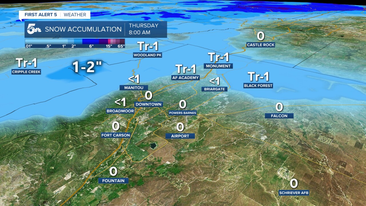
The next round of moisture comes as rain and a few thunderstorms Thursday afternoon with rain turning to snow Thursday night through Friday morning. The map at the top of this story shows how much snow we're expecting by Friday morning. We'll see snow showers in the foothills and mountains Friday and Saturday with dry skies by Sunday. We'll see snow showers move in Monday night through Tuesday morning.
KOAA News5 on your time, streaming on your Roku, FireTV, AppleTV and AndroidTV.
News5 App | First Alert 5 Weather App | Youtube | Facebook | Instagram | Twitter
