

Today’s Forecast:
Quite the mixed bag of weather forecast across southern Colorado over the next 24 hours. We will see scattered showers and even a couple of thunderstorms this afternoon followed by snow overnight through Friday.
Thunderstorms look pretty scattered out there today with the most likely areas in eastern Fremont, Pueblo, Otero, and Crowley counties. Rain could rumble in parts of El Paso County, but the better storm energy is south.
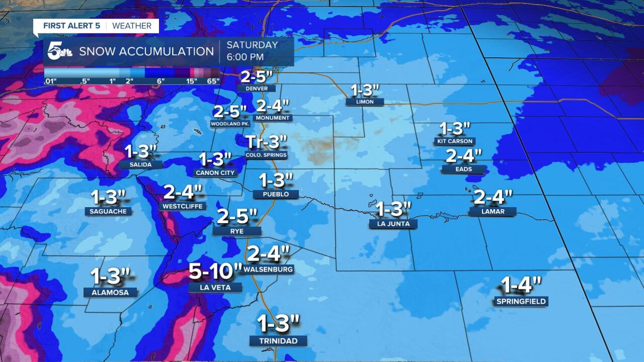
Snow wraps around a low-pressure system tonight and should drop light to heavy snow depending on your elevation and location. The heaviest snow will fall along the Palmer Divide into northern El Paso county and back through Teller county. This will lead to really slick conditions overnight through early Friday morning in the Pikes Peak Region, and much lighter accumulations south in our mountains and valleys.
COLORADO SPRINGS: High: 48; Low: 29. Showers in the afternoon will turn to snow this evening, and there could be a few rumbles of thunder within the rain and the start of our snow. Snow will fall with strong, gusty winds tonight, and we could have limited visibility for those driving overnight, especially in northern El Paso County and up north to Denver.
PUEBLO: High: 58; Low: 33. Showers and even isolated thunderstorms are possible this afternoon with light snow showers falling overnight through Friday morning. Severe weather is not expected today, but gusty winds, lightning, and even a few areas of small hail could fall under some of the stronger thunderstorms. Snow overnight and Friday morning should really only accumulate on the grass.
CANON CITY: High: 57; Low: 34. Isolated showers are possible this afternoon, and we could have a few rumbles of thunder from Canon City through eastern Fremont County. Snow showers will drop in tonight through Friday morning, but snow accumulations are expected to be under two inches in lower Fremont County, probably a few inches in the Wet Mountains and the high country north of Canon City.
WOODLAND PARK: High: 46; Low: 20. Scattered rain showers turn to snow quickly this afternoon with heavier and more consistent snow through the evening and overnight hours. We could see moderate to heavy snow through Friday morning with slushy and snowy roads overnight. More light snow will fall through the day Friday but with light accumulations.
TRI-LAKES: High: 40s; Low: 20s. Showers are possible in the afternoon with snow moving into tonight through Friday morning. Snow could be moderate to heavy at times with accumulations stacking up pretty well by Friday morning, and another inch or so through Friday afternoon. I-25 in Monument and north to Denver will get very snowy overnight and travel could be an issue Friday morning.
PLAINS: High: 50s; Low: 30s. Showers and thunderstorms are likely today along and north of Highway 50 in the afternoon and early evening. If we see thunderstorms, eastern Pueblo, Crowly, Otero, and Lincoln counties are the most likely areas with lightning, gusty winds, and small hail as the main threats. Snow could wrap around overnight into the Highway 50 corridor, but accumulations are expected to stay at or close to zero.
WALSENBURG/TRINIDAD: High: 50s; Low: 20s. Windy and dry until a few spotty showers try and develop this afternoon and evening. Light snow could drift south overnight but accumulations along the southern I2-5 corridor should be less than 1 inch of snow, and even that would be in the grass.
MOUNTAINS: High: 40s; Low: 20s. We will see areas of rain during the day with a switch to snow overnight. The heaviest snow will be in the mountains of Fremont, Teller, and western El Paso counties overnight through Friday morning, but we could see another couple of inches through the afternoon Friday.
Extended Outlook:
Snow showers during the day Friday and Saturday will mainly stick to the mountains and areas west of I-25, but a few flakes could hop out to I-25 in areas like Colorado Springs, Walsenburg, and Trinidad. We'll see more snow Monday night through Tuesday morning of next week, and a rain to snow chance Wednesday through Thursday.
KOAA News5 on your time, streaming on your Roku, FireTV, AppleTV and AndroidTV.
News5 App | First Alert 5 Weather App | Youtube | Facebook | Instagram | Twitter
