

Tonight's Forecast:
It will take a few hours after sunset for temperatures to really start to cool down. 80s and 90s will last through the dinnertime hours. A few spotty showers will be possible along the Palmer Divide, closer to Monument. Skies will clear out overnight.
UV levels are supposed to reach extreme levels, so make sure to take plenty of breaks in the shade if you plan on being outside. It doesn't take a lot of time to cause a sunburn.
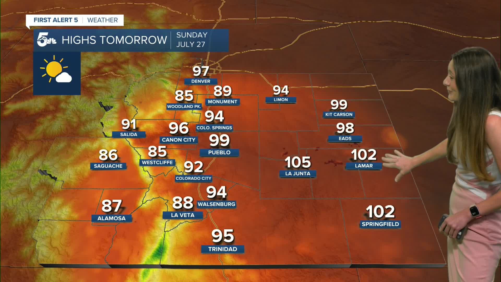
Colorado Springs forecast: Low: 58; High: 94;
Colorado Springs will have a warm evening with temperatures cooling into the mid 80s around 6PM. Overnight lows will drop into the upper 50s. The Springs will stay mostly clear going into Sunday, and highs will be a few degrees warmer than today. With warm temperatures and high UV levels, it is important to take plenty of water and shade breaks throughout the day.
Pueblo forecast: Low: 59; High: 99;
It will take a few hours for temperatures to eventually drop into the 80s, so expect a classic summer evening. Skies will stay clear and this will remain through Sunday. Highs on Sunday will be a few degrees warmer in the upper 90s. Conditions will stay dry through the beginning of the work week.
Canon City forecast: Low: 62; High: 96;
Canon City will have overnight lows in the lower 60s. Skies will remain mostly clear for Sunday. Temperatures will heat up early on in the day and afternoon highs will be in the mid-90s.
Woodland Park forecast: Low: 53; High: 85;
Woodland Park will have some more clouds throughout the area, but this will clear overnight. Temperatures will drop into the lower 50s by the early morning hours. Temperatures Sunday afternoon will be in the mid-80s. Skies will remain mostly clear.
Tri-Lakes forecast: Low: 55; High: 89;
The Monument area will have the possibility of a few spotty showers, but these will wrap up around sunset. Overnight lows will drop into the mid-50s. Highs on Sunday will warm into the upper 80s. Conditions are expected to stay dry.
Plains forecast: Low: 60s; High: 90s & 100s;
The plains will have a warm evening with temperatures slow to cool. The heat will return on Sunday with highs in the 90s and triple digits. Rain won't return into the forecast until the middle of the upcoming work week.
Walsenburg and Trinidad forecast: Low: 60/58; High: 94/95;
Walsenburg and Trinidad will have a few passing clouds this evening with temperatures slow to cool. Morning lows on Sunday will be in the 50s and 60s. Temperatures throughout the day will warm into the mid-90s. UV levels are also supposed to reach extreme levels.
Mountains forecast: Low: 50s & 40s; High: 80s & 90s;
The mountains will have overnight temperatures in the 40s and 50s. Sunday will have highs in the 80s and 90s. Conditions are expected to stay mostly clear throughout the area.
Extended outlook forecast:
Warm conditions last through the beginning of the week. Moisture will return going into Tuesday and a couple of disturbances will increase the rain chances. By Wednesday, rain chances are expected to increase and rain could at heavy at times. A flash flooding risk will return with the increase in rain. Temperatures will decrease closer to the seasonal average. Looking ahead to the beginning of August, temperatures look to be above average.
____
Curious about the First Alert 5 Weather Storm Impact Scale? Check out our cheatsheet explainer.
Watch KOAA News5 on your time, anytime with our free streaming app available for your Roku, FireTV, AppleTV and Android TV. Just search KOAA News5, download and start watching.
