


Tonight's Forecast:
Temperatures will be slow to cool tonight, and overnight lows will drop into the 50s and 60s across southern Colorado. Temperatures will heat up again into the 90s for I-25 and triple digits along the Arkansas River Valley. Drink plenty of water and take shade breaks if you plan to be outside.A few scattered thunderstorms will be possible in the mountains, but I-25 will stay mostly dry.
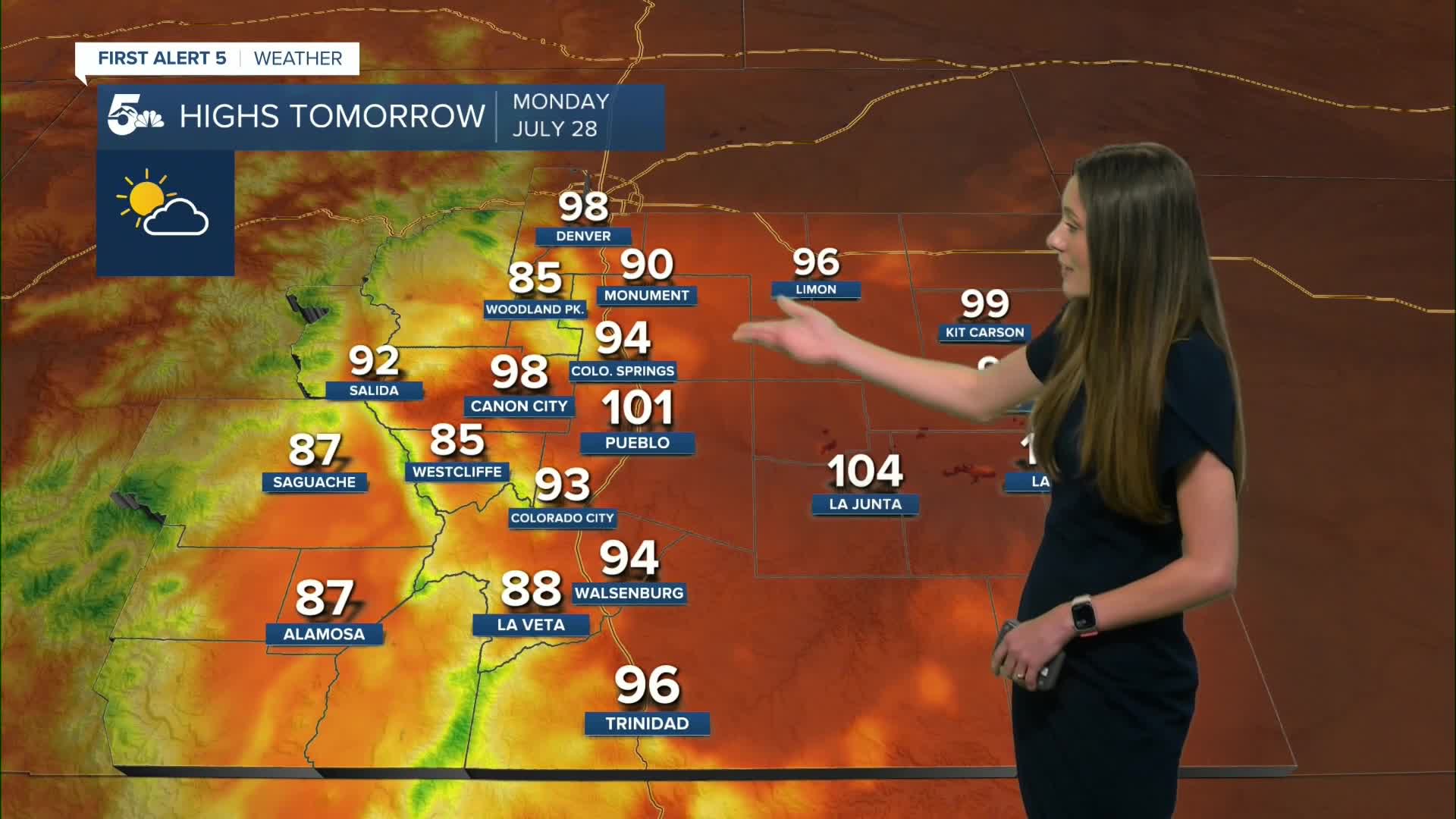
Colorado Springs forecast: Low: 61; High: 94;
Colorado Springs will slowly cool into the lower 60s overnight and into Monday morning. Temperatures will be in the 90s again by the late afternoon. Chances of rain remain on the lower side. Rain chances will pick up going into Tuesday.
Pueblo forecast: Low: 62; High: 101;
Pueblo has another hot day ahead of them with highs reaching the lower 100s. No rain is expected on Monday. Conditions will likely stay dry through Tuesday, but there will be a few spotty showers in the area. Temperatures will cool going into the middle of the week.
Canon City forecast: Low: 65; High: 98;
Canon City will have overnight lows in the mid-60s. Highs will be hot again on Monday in the upper 90s. Conditions will stay dry throughout the day. There will be an increase in clouds throughout the afternoon. Moisture will return on Tuesday and increase the rain chances.
Woodland Park forecast: Low: 52; High: 85;
Woodland Park will also have warm temperatures return on Monday staying in the mid-80s. There will be some increasing cloud cover throughout the day on Monday. There will be a 20% chance of rain in the afternoon.
Tri-Lakes forecast: Low: 60; High: 90;
Monument will have a rare day where highs will reach the 90s. Morning lows will be in the 60s. Temperatures will cool throughout the week as rain chances pick up. Heavy rain will be possible towards the middle of this week.
Plains forecast: Low: 60s; High: 90s & 100s;
The plains will have another day of hot temperatures across the area. Highs will reach the triple digits along the Arkansas river, but things will stay dry. Rain chances won't pick up until Wednesday.
Walsenburg and Trinidad forecast: Low: 63/62; High: 94/96;
The southern I-25 corridor will have temperatures drop into the lower 60s overnight. Hot conditions return to the area Monday afternoon. A few spotty showers will be possible for the mountains and closer to the San Juans. Highs will be in the mid-90s.
Mountains forecast: Low: 50s; High: 80s & 90s;
The mountains will start to see the increase in moisture. Spotty showers will pop up around noon and then build throughout the day. Temperatures will rise into the 80s and 90s. Rain chances will remain throughout the majority of the week.
Extended outlook forecast:
With the return of moisture, rain chances will increase throughout the week. There is a concern for flash flooding going into Wednesday and Thursday. A few models have between 1-2" of rainfall on Wednesday for the Pikes Peak Region. There is a slight risk (2/4) for excessive rainfall and the risk of flash flooding.
Drier air will enter into the area going into the weekend, so things look to start drying out around that time
____
Curious about the First Alert 5 Weather Storm Impact Scale? Check out our cheatsheet explainer.
Watch KOAA News5 on your time, anytime with our free streaming app available for your Roku, FireTV, AppleTV and Android TV. Just search KOAA News5, download and start watching.
