


Tonight's Forecast:
Overnight lows across the area will drop into the 50s & 60s. The next few days will be mostly calm with just a few isolated thunderstorms closer to the plains. Each day will get progressively hotter as a high-pressure system continues to build.
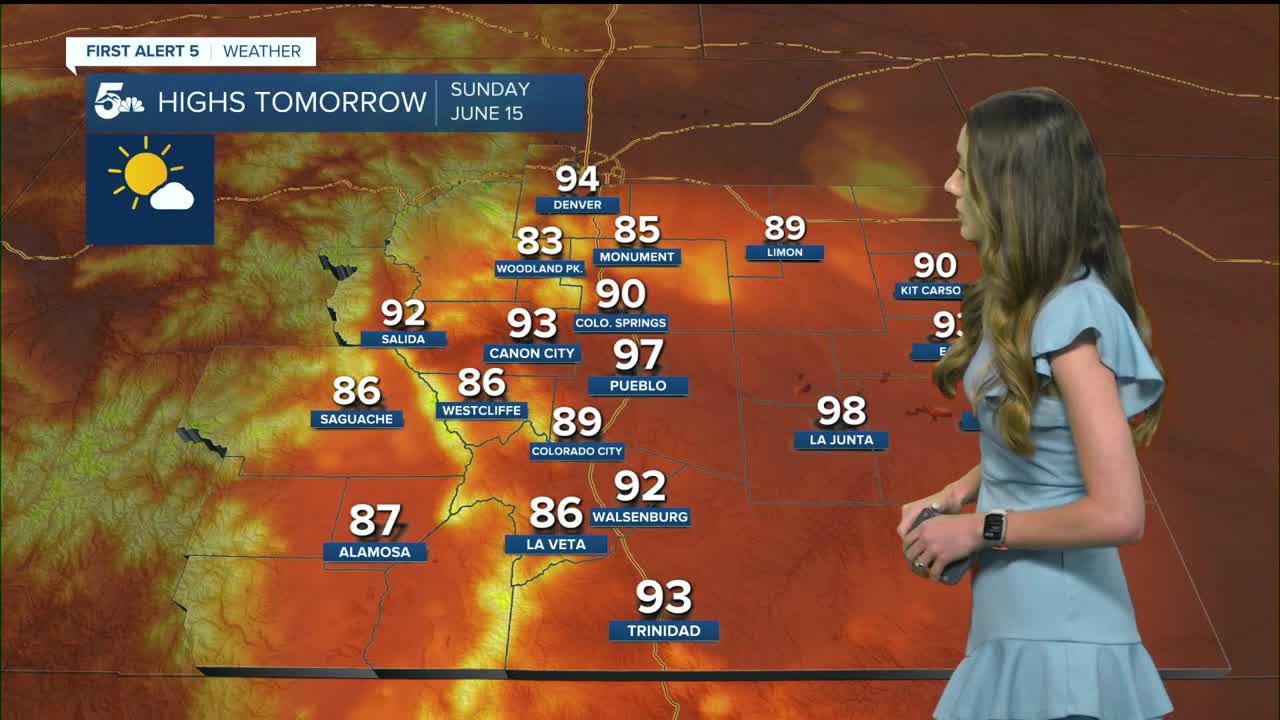
Colorado Springs forecast: Low: 58; High: 90;
Highs for Sunday will continue to warm eventually topping out around 90 degrees. This would be the first 90 degree day for the Springs this year. There is a small chance for rain, but conditions will likely remain mostly sunny.
Pueblo forecast: Low: 59; High: 97;
Pueblo will continue with mostly clear for Father's Day. Highs will be a few degrees warmer than Saturday. If you plan on being outdoors, bring plenty of water. Highs will top out in the upper 90s.
Canon City forecast: Low: 60; High: 93;
Canon City will have mostly clear skies and this will help to warm temperatures early on. By noon, temperatures will be in hovering at 90 degrees. Highs for the day will be in the lower 90s.
Woodland Park forecast: Low: 50; High: 84;
Warmer weather will continue through the back half of the weekend with highs continuing to climb. Temperatures will reach the mid-80s by the afternoon. The chance of rain will remain on the lower side.
Tri-Lakes forecast: Low: 57; High: 92/93;
The Monument area on Sunday will have temperatures in the lower 70s around 9AM. With plenty of sunshine, these temperatures will warm into the mid-to-upper 80s by the afternoon.
Plains forecast: Low: 60s; High: 90s;
The plains will have another day of hot and above average temperatures. There is a higher potential for thunderstorms out that way due to the leftover moisture. It also wouldn't be out of the question for a couple of 100 degree temperatures along the Arkansas River on Sunday.
Walsenburg and Trinidad forecast: Low: 57/56; High: 92/93;
The southern I-25 corridor will have mostly clear conditions with temperatures in the mid-70s by 9AM. Highs will eventually reach the lower 90s. Rain chances remain low Sunday and Monday. Winds will also pick up on Monday.
Mountains forecast: Low: 40s & 50s; High: 80s;
The mountains won't have as much moisture as the past couple of days so storm and rain chances remain low. Temperatures will rise into the 80s across the mountains.
Extended outlook forecast:
Drier air will also continue to move in which will limit shower and thunderstorms for the rest of the weekend and into the beginning of the week. Monday looks to be the hottest day with the potential to reach 90s in certain areas.
____
Curious about the First Alert 5 Weather Storm Impact Scale? Check out our cheatsheet explainer.
Watch KOAA News5 on your time, anytime with our free streaming app available for your Roku, FireTV, AppleTV and Android TV. Just search KOAA News5, download and start watching.
