

Today’s Forecast:
Break out the tee shirts and shorts!
Stunning temperatures are back in Colorado today with the only negative being grass fire danger along I-25 from Pueblo to Trinidad.
Forecast high temperatures are expected to be in the 60s along and east of I-25. The mountains will fair well with highs in the 50s.
A High Wind Warning is in effect for the Sangre De Cristos and gap flow areas like Walsenburg, Colorado City, and Aguilar. We could see gusts down the eastern slopes of the Sangres get as high as 80 mph today and early tonight.
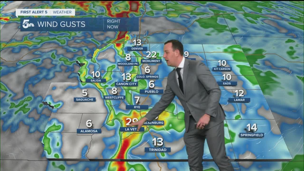
Colorado Springs forecast: High: 65; Low: 39. Mostly cloudy and super warm today! We'll be windy across the west side of town with wind gusts in the 30 mph range. Highs will easily climb into the 60s today, even with overcast skies in the afternoon.
Pueblo forecast: High: 69; Low: 38. Mostly cloudy in the afternoon with breezy and very warm daytime conditions. Highs could easily hit 70 degrees today thanks to gusty west winds in the afternoon. Fire danger is high today due to dry grasses, low humidity, and 20 mph wind gusts.
Canon City forecast: High: 64; Low: 46. Gorgeous temperatures with gusty daytime winds. We could see gusts in the 20 to 30 mph range with highs in the mid 60s.
Woodland Park forecast: High: 53; Low: 34. Really warm and gusty with overcast skies in the afternoon. Highs will warm to the 50s with wind gusts int he 30 to 40 mph range.
Tri-Lakes forecast: High: 50s; Low: 30s. Warm and windy today with gusts in the 30 to 40 mph range. We'll see highs in the 50s even with overcast afternoon skies.
Plains forecast: High: 60s; Low: 30s. Really warm and breezy today with areas of high fire danger in eastern Pueblo and Las Animas counties. Highs will be in the 60s through the afternoon.
Walsenburg and Trinidad forecast: High: 60s; Low: 40s. Really windy today with high fire danger through the afternoon. It'll be very warm with downslope gusts maxing out in the 40 to 60 mph range.
Mountains forecast: High: 50s; Low: 30s. A High Wind Warning is in effect along the Front Range from Castle Rock north through Wyoming, as well as the Sangre De Cristos and local gap-flow areas. Gusts in the Sangres could get as strong as 80 mph today and tonight with lesser gusts along I-25. Heavy snow will start falling along the western slope tonight and continue to dump heavy snow through Thursday morning.
Extended outlook forecast:
Wednesday will stay pretty warm and gusty with highs likely in the 50s under heavier cloud cover.
Heavy snow will continue through the Continental Divide Wednesday and Wednesday night, making travel west of Georgetown on I-70 likely very slick and dangerous at times. Monarch Pass could easily see a foot of snow from tonight through early Thursday morning.
A cold front locally will bring a shot of snow Wednesday night through early Thursday morning. Accumulating snow chances are best in the Pikes Peak Region, where a general range of 0.5 to 3 inches is expected as of now. Pueblo and Canon City could see snow Wednesday night, but accumulation is unlikely.
We'll stay chilly through the weekend with a chance for snow next Monday.
____
Curious about the First Alert 5 Weather Storm Impact Scale? Check out our cheatsheet explainer.
Watch KOAA News5 on your time, anytime with our free streaming app available for your Roku, FireTV, AppleTV and Android TV. Just search KOAA News5, download and start watching.
