

Tonight's Forecast:
High wind warning will still be in place through the night for the higher terrain. Temperatures won't be too cold overnight with some areas only dropping into the 40s. Colder temperatures will move in towards the plains with lows in the 30s.
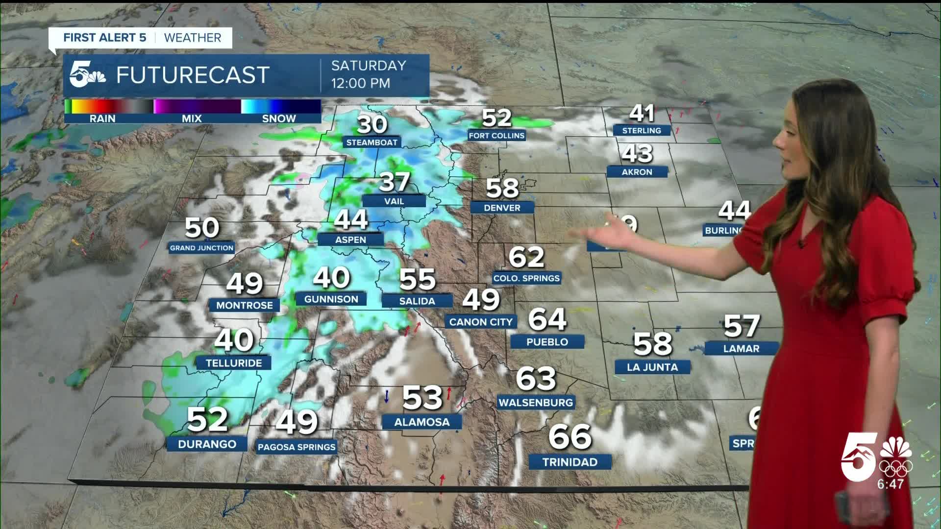
Colorado Springs forecast: Low: 42; High: 61;
Colorado Springs will have some breezy conditions, but temperatures will remain warm. We will only get down into the 40s. By the afternoon, 60s will return and conditions will remain dry. We will have partly cloudy conditions.
Pueblo forecast: Low: 41; High: 65;
Pueblo will reach overnight lows in the 40s. Some cooler temperatures are possible further east along highway 50. Afternoon highs will rise into the mid-60s. Some breezy conditions will linger throughout the day, but they won't be as strong as Friday's winds.
Canon City forecast: Low: 44; High: 64;
Canon City has been dropped from the high wind warnings. There will still be some breezy conditions possible, but they will be outside of the criteria for the warnings. Overnight lows will drop into the 40s. By the afternoon, temperatures will be in the mid-60s.
Woodland Park forecast: Low: 36; High: 53;
Woodland Park will likely still see some windy conditions overnight. Teller county will be included in the high wind warning through Saturday morning. Afternoon highs will be in the lower 50s.
Tri-Lakes forecast: Low: 43; High: 59;
Monument will have overnight temperatures in the lower 40s. Partly cloudy skies will last throughout the day and this will mainly be upper level clouds. Afternoon highs will be in the upper 50s. Some breezy conditions will remain.
Plains forecast: Low: 30s; High: 50s & 60s;
The plains will have some windy conditions overnight between 20 and 30mph. Temperatures will also be chilly and get close t freezing. Afternoon highs on Saturday will be in the 50s and 60s.
Walsenburg and Trinidad forecast: Low: 42/39; High: 63/68;
Walsenburg will have some stronger gusts upper to 30mph overnight. Winds will be a touch lighter closer to Trinidad. Lows tomorrow morning will be in the upper 30s and lower 40s. By the afternoon, these temperatures will rise into the 60s.
Mountains forecast: Low: 30s; High: 50s;
High wind warnings will be in effect until Saturday morning. The mountains will be hard to travel through tomorrow with snow moving in. Winds will continue to be strong at times and could limit visibility. Lows will be in the 30s and by the afternoon, temperatures will be in the 50s.
Extended outlook forecast:
Looking ahead, temperatures will take a dip on Sunday with highs in the 50s. This is still above average for this time of year. Temperatures will warm into the 60s and 70s as we head into the week. Christmas Day still looks warm with highs in the 60s.
____
Curious about the First Alert 5 Weather Storm Impact Scale? Check out our cheatsheet explainer.
Watch KOAA News5 on your time, anytime with our free streaming app available for your Roku, FireTV, AppleTV and Android TV. Just search KOAA News5, download and start watching.
