Today’s Forecast:
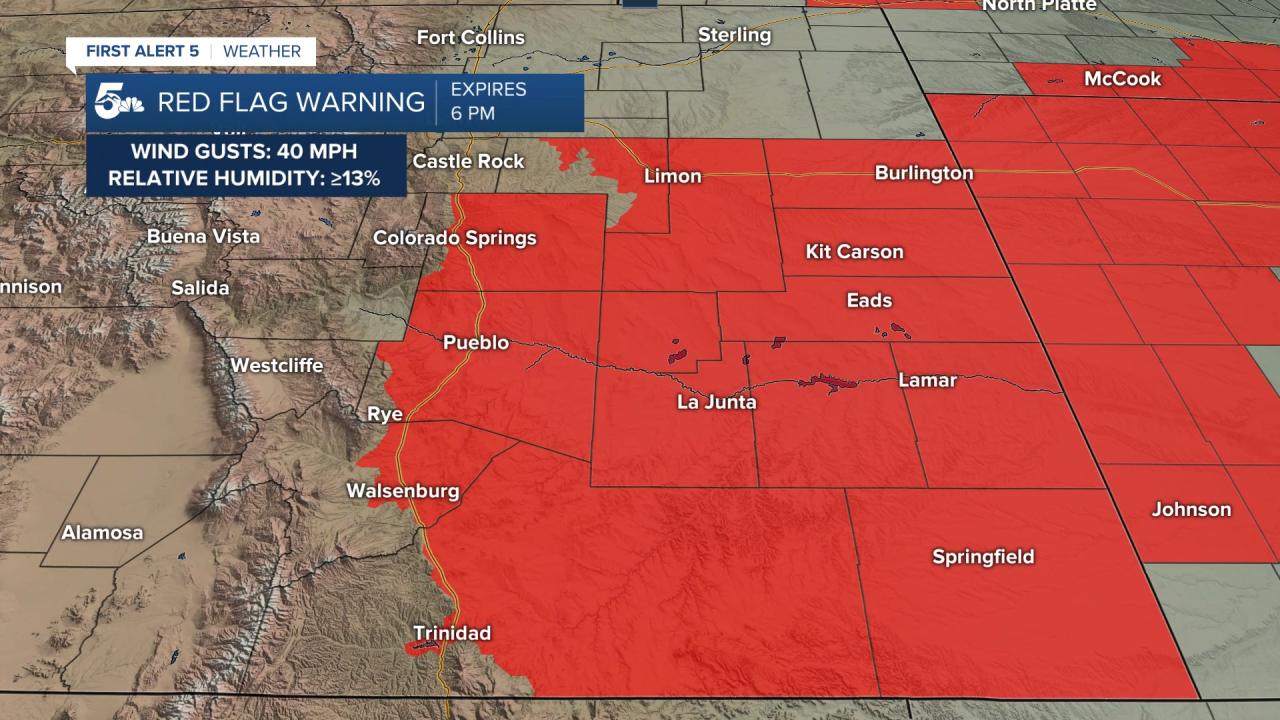
High fire danger returns to the plains this afternoon.
Strong southwest jet stream flow over the state will mix gusty winds and really dry air down the mountains and east across the plains.
Grass fires are the main concern today, especially along I-25 in larger populated areas like Colorado Springs and Pueblo.
Colorado Springs forecast: High: 68; Low: 39. High fire danger today with wind gusts in the 30 mph range and humidity as low as 13 percent. Grass fires are the primary concern today, especially along popular roads and near homeless encampments.
Pueblo forecast: High: 75; Low: 39. Windy and dry with high fire danger through the afternoon. Southwest gusts in the 20 mph range with humidity under 15 percent are the cause of our grass fire danger today.
Canon City forecast: High: 74; Low: 39. Windy and dry with high fire danger in the afternoon. Like Pueblo, southwest gusts will be in the 20 mph range with humidity under 15 percent.
Woodland Park forecast: High: 59; Low: 31. Chilly and windy with daytime gusts in the 30 mph range. We won't have low enough humidity for Red Flag Warnings, but fire danger is still elevated in dry grassy areas.
Tri-Lakes forecast: High: 60s; Low: 30s. Chilly and windy with elevated fire danger through the afternoon. We'll have strong enough wind for fire danger, but the humidity won't be low enough.
Plains forecast: High: 70s; Low: 40s. Windy and very dry with fire danger through the afternoon. Gusts will be in the 20 to 40 mph range, especially south of Highway 50.
Walsenburg and Trinidad forecast: High: 60s; Low: 40s. Windy with high fire danger from the late morning to the early afternoon. Wind gusts could be in the 30 to 40 mph range with humidity as low as 13 percent.
Mountains forecast: High: 50s; Low: 30s. Windy and cold across the mountains with a large system approaching from the west. We could see snow on the western slope tonight, but most of the mountains locally look dry and windy with gusts in the 30 to 40 mph range.
Extended outlook forecast:
A large system moving across the west coast will start to throw heavy snow in the mountains of Colorado tomorrow. The San Juan mountains will see the heaviest snow accumulations with Wolf Creek Pass seeing anywhere from 20 to 30 inches through Friday morning.
Locally, we'll get a very strong cold front to drop across the plains through the late afternoon with lots of wind and rapidly falling temperatures. Snow showers will follow the cold front Thursday night, with some of the most accumulation happening along the Palmer Divide and north up around Denver and the mountains west.

Evening commutes to and from Denver Thursday could be very challenging from a heavy burst of snow that lowers visibility and leads to some snow accumulation on less traveled roads. Citywide snow accumulation in Colorado Springs will be an inch or less, but areas north of Briargate could see up to 2 inches. Pueblo could see snow at times Thursday night, but accumulations look very low at this time.
The weekend will be dry locally and windy with highs in the 60s and low 70s.
____
Curious about the First Alert 5 Weather Storm Impact Scale? Check out our cheatsheet explainer.
Watch KOAA News5 on your time, anytime with our free streaming app available for your Roku, FireTV, AppleTV and Android TV. Just search KOAA News5, download and start watching.


