


Today’s Forecast:
Snow starts to arrive this afternoon to the higher elevation areas in our region, and turns into a heavy snow from the end of the day through the overnight hours. We're going to see heavy snow and very slow/dangerous commutes Tuesday morning as the snowfall finally stops. Below are more detailed forecast maps through the region.

COLORADO SPRINGS: High: 33; Low: 13. Snow begins this afternoon and ends early Tuesday morning. Snowfall totals will be wide ranging across the city, and generally an inch or so less on the east side of town. Above freezing temperatures will lead to pavement that stays wet during the day, and then freezes overnight with fresh snow dumped on top by Tuesday morning.
TRI-LAKES: High: 20s; Low: >10. Snow starts up around and just after lunch and lasts through early Tuesday morning. Snowfall will be fairly heavy from the end of the day through the overnight hours, and there will likely be some areas of town that see get icy and then snow covered by Tuesday morning.
WOODLAND PARK: High: 31; Low: 7. Snow starts up around lunch time and continues through early Tuesday morning. The pavement will probably stay right around freezing but there could still be some icy areas that see snowfall overnight.

PUEBLO: High: 37; Low: 15. Moderate to heavy snow arrives this evening and last into Tuesday morning. We'll be warm enough where most of the pavement will be wet when snow starts to fall, and then freeze with ice that snow will then fall on top of. We will likely see very slow and slick commutes Tuesday morning.
CANON CITY: High: 39; Low: 19. Similar to Pueblo, snow starts to fall at the end of the day and lasts through Tuesday morning. Above freezing daytime temps will lead to icy streets as we freeze and then dump snow on the roads overnight. We're expecting several slick drives on highway 50 as well as highways into the mountains outside of town.
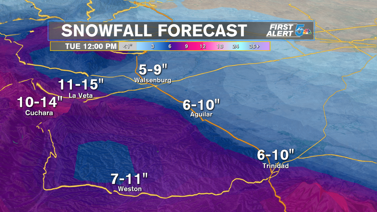
WALSENBURG/TRINIDAD: High: 30s; Low: 10s. Snowfall comes to the mountains later today and continues heavily overnight through Tuesday morning. Very heavy snowfall is expected through the region, with several spots of I-25 likely getting icy from above freezing daytime temperatures. Some of the slickest drives in the area tonight and tomorrow will be La Veta and Raton Pass.
PLAINS: High: 30s; Low: 10s. Looking at the snow map at the top of this story, snowfall totals across the plains will generally be highest the closer you are to I-25 and the New Mexico border. Las Animas County will see the biggest snow accumulations between 2 to 5 inches, but La Junta will be somewhere between 1 to 4 inches through Tuesday morning. We're expecting plenty of slick drives Tuesday morning, even in areas that see less than 2 inches.
Extended Outlook:
Isolated flurries are possible on Wednesday, but mostly in the mountains areas like Teller and western Fremont Counties. We look dry and warmer from Thursday through the weekend.
