

Tonight's Forecast:
Temperatures overnight will be pretty mild with lows reaching the 20s and 30s. Skies will gain more clouds overnight and this is what will help to keep temperatures on the warmer side. You will still need a jacket if you have an early start to your Saturday.
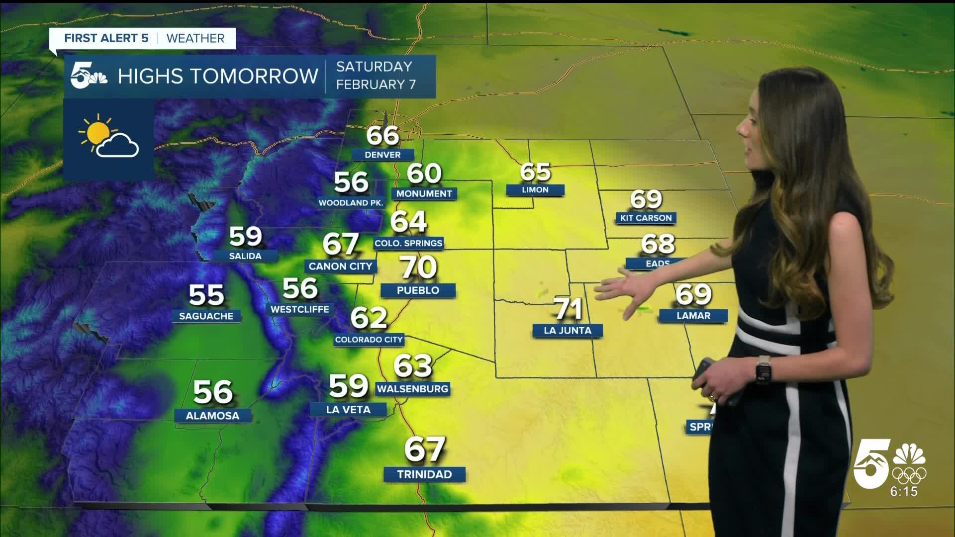
Colorado Springs forecast: Low: 34; High: 64;
The Springs isn't done with the warm temperatures quite yet, and afternoon highs will make it into the mid-60s. For anyone that's headed downtown to Winterfest, they will be met with great conditions. The evening temperatures will be slow to cool. Clouds will continue to decrease throughout the day.
Pueblo forecast: Low: 27; High: 70;
Pueblo will have some of the warmest temperatures in the area tomorrow. Morning temperatures will still be chilly, but by the afternoon highs will reach the 70s. Clouds will move out of the area during the day.
Canon City forecast: Low: 37; High: 67;
Canon City won't be too cold overnight, but temperatures will still be chilly enough for a jacket. Lows will be in the upper-30s. By the afternoon these temperatures will be in the upper-60s, so get outside and enjoy the warmer weather!
Woodland Park forecast: Low: 30; High: 56;
Woodland Park will get below freezing overnight, and lows will get down to 30 degrees. The day will start off with more clouds, but gradually clear during the day. Highs in the afternoon will make it into the mid-50s.
Tri-Lakes forecast: Low: 35; High: 60;
Monument will wake up to temperatures in the mid-30s. There will be more clouds and conditions will be breezy at times throughout the day. Afternoon highs will make it into the 60s.
Plains forecast: Low: 20s; High: 60s & 70s;
The eastern plains will be cold overnight with morning lows in the 20s. This will be short-lived because temperatures will get into the 60s and 70s by the afternoon. There will be some breezy conditions during the day, so hold onto those hats!
Walsenburg and Trinidad forecast: Low: 36/33; High: 63/67;
The southern I-25 corridor will have overnight lows in the lower-to-mid-30s. There will be more clouds during the morning hours, but they will quickly exit the area by the afternoon. With more sunshine this will allow temperatures to make it into the 60s.
Mountains forecast: Low: 20s; High: 50s;
The mountains will have clouds fill in overnight, but by the afternoon tomorrow they will thin out. With more sun during the afternoon, highs will make it into the 50s.
Extended outlook forecast:
We are on cruise control with this forecast for the next few days. Highs will be in the 60s through Monday. We won't be seeing any noticeable changes until Tuesday. More clouds will start to move in along with the incoming system. Rain and snow chances will pick up around this time, but these chances remain low around 10% starting off. Wednesday currently has the best chances for rain and snow showers.
____
Curious about the First Alert 5 Weather Storm Impact Scale? Check out our cheatsheet explainer.
Watch KOAA News5 on your time, anytime with our free streaming app available for your Roku, FireTV, AppleTV and Android TV. Just search KOAA News5, download and start watching.
