

Tonight's Forecast:
Tonight, temperatures will creep down into the 40s for the plains and I-25. The higher terrain will be a touch cooler, making it into the 30s. Winds will calm down overnight, but will pick back up tomorrow.
Colorado Springs forecast: Low: 41; High: 70;
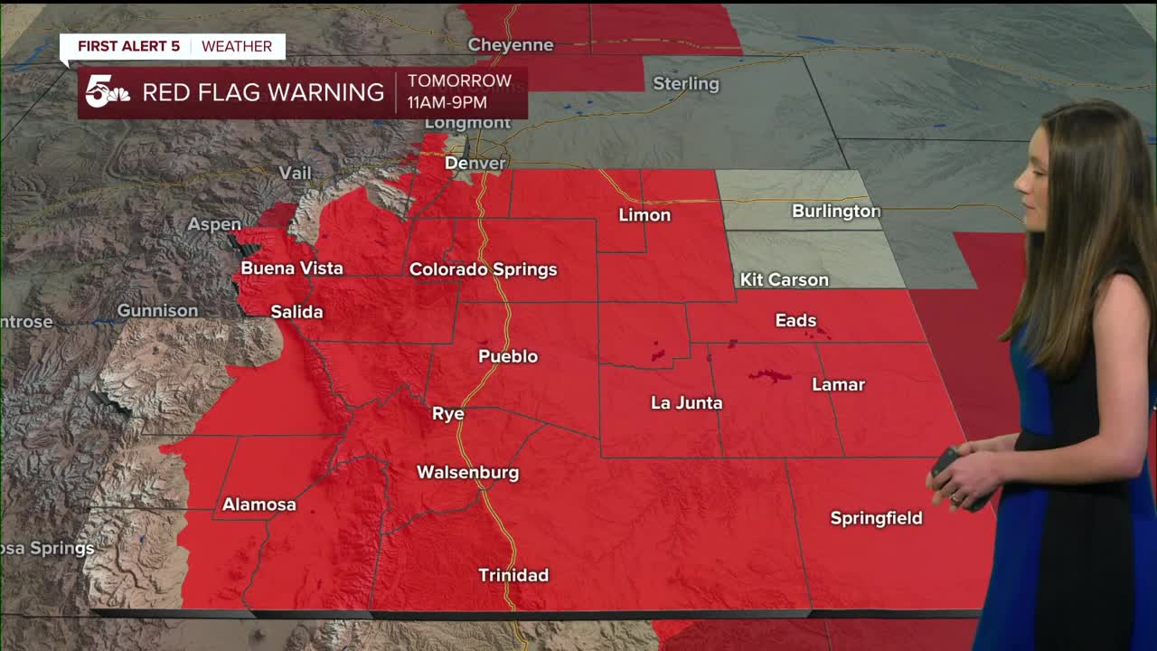
Colorado Springs will continue with the fire danger risk and red flag warnings will be in place from 11AM until 9PM. Gusts have the possibility of reaching 45mph. Temperatures will also stay warm with highs in the 70s.
Pueblo forecast: Low: 41; High: 76;
Pueblo will have temperatures in the lower-40s in the morning. Winds will start to pick up by the mid-morning and will be gusty into the evening. Fire danger will be a concern tomorrow as well. Highs in the afternoon will be in the mid-70s.
Canon City forecast: Low: 42; High: 72;
Canon City will wake up to temperatures in the lower-40s, and winds will pick up around 11AM. This is also when red flag warnings will go into effect, so just be cautious outside. Winds will be gusty into the afternoon and evening. Highs will be in the lower-70s.
Woodland Park forecast: Low: 34; High: 61;
Woodland Park will have a chilly start compared to others with lows in the mid-30s. Teller county will be in a red flag warning from 11AM until 9PM. Winds will continue to be gusty into the evening. Afternoon temperatures will be in the lower-60s.
Tri-Lakes forecast: Low: 40; High: 65;
Monument and the surrounding area will have temperatures in the lower-40s tomorrow morning. Highs will eventually make it into the mid-60s. Winds and dry conditions will create some fire danger concerns during the day.
Plains forecast: Low: 40s; High: 70s & 80s;
The eastern plains will have temperatures in the 40s to start off the day. The warmest temperatures will be along highway 50 and the Arkansas River. 80s are back in the forecast for these areas. Winds will be on the stronger side and red flag warnings will be in place.
Walsenburg and Trinidad forecast: Low: 43/40; High: 67/72;
The southern portion of I-25 will have morning temperatures in the 40s. Winds will be gusty and will reach 40-50mph at times. Humidity values will be low as well. Fire danger will be a concern because of this. Afternoon highs will be in the upper 60s and lower 70s.
Mountains forecast: Low: 30s; High: 60s;
The mountains will have the strongest gusts, especially towards the peaks. Morning temperatures will be in the 30s and the afternoon temperature will be in the 60s.
Extended outlook forecast:
Fire danger continues into Tuesday, and around this time is when the next system arrives. By the afternoon on Tuesday, the chance for rain will pick up. Some of the models have been trending a little drier with this. The next chance for some moisture arrives at the end of the week.
Models are currently showing some mixed precipitation towards the end of the week Friday evening into Saturday morning. Some cold air will get pushed into the state along with some mositure.
____
Curious about the First Alert 5 Weather Storm Impact Scale? Check out our cheatsheet explainer.
Watch KOAA News5 on your time, anytime with our free streaming app available for your Roku, FireTV, AppleTV and Android TV. Just search KOAA News5, download and start watching.
