

Tonight's Forecast:
Clouds clear out tonight with lows for the I-25 corridor getting down into the 50s. For the eastern plains, temperatures will be a few degrees warmer in the 50s and 60. The higher terrain will have cooler temperatures in the 40s and 50s.
Father's Day Forecast:
The day will start off clear, but as we get into the afternoon hours there will be some more clouds. Some models are showing some showers developing in eastern El Paso county by 2PM. As these showers move east, the atmosphere becomes a little bit more unstable, and severe storms will be possible. Areas like La Junta, Springfield, and Limon will have the chance for a stronger storm.
Highs will be on the warm side with 90s expected for both Colorado Springs & Pueblo. Fire danger continues to be a concern closer to Fremont county. If you plan on grilling, just be extra cautious with any sparks.
Colorado Springs forecast: Low: 57; High: 90;
Colorado Springs will have early morning temperatures in the upper 50s. Conditions will be nice in the morning with clear skies. More clouds move in around lunchtime, and you may notice some shower activity as these clouds push into the eastern portion of El Paso county. Highs will be back in the 90s, and a few areas in the Springs will be in the upper 80s.
Pueblo forecast: Low: 59; High: 98;
Pueblo will have morning lows in the upper 50s, and from there temperatures warm up fast. Definitely a nice day for the pool with dad and family. Afternoon highs will get up to the upper 90s. The evening will be slow to cool, but by 8PM temperatures will have cooled into the 80s.
Canon City forecast: Low: 60; High: 95;
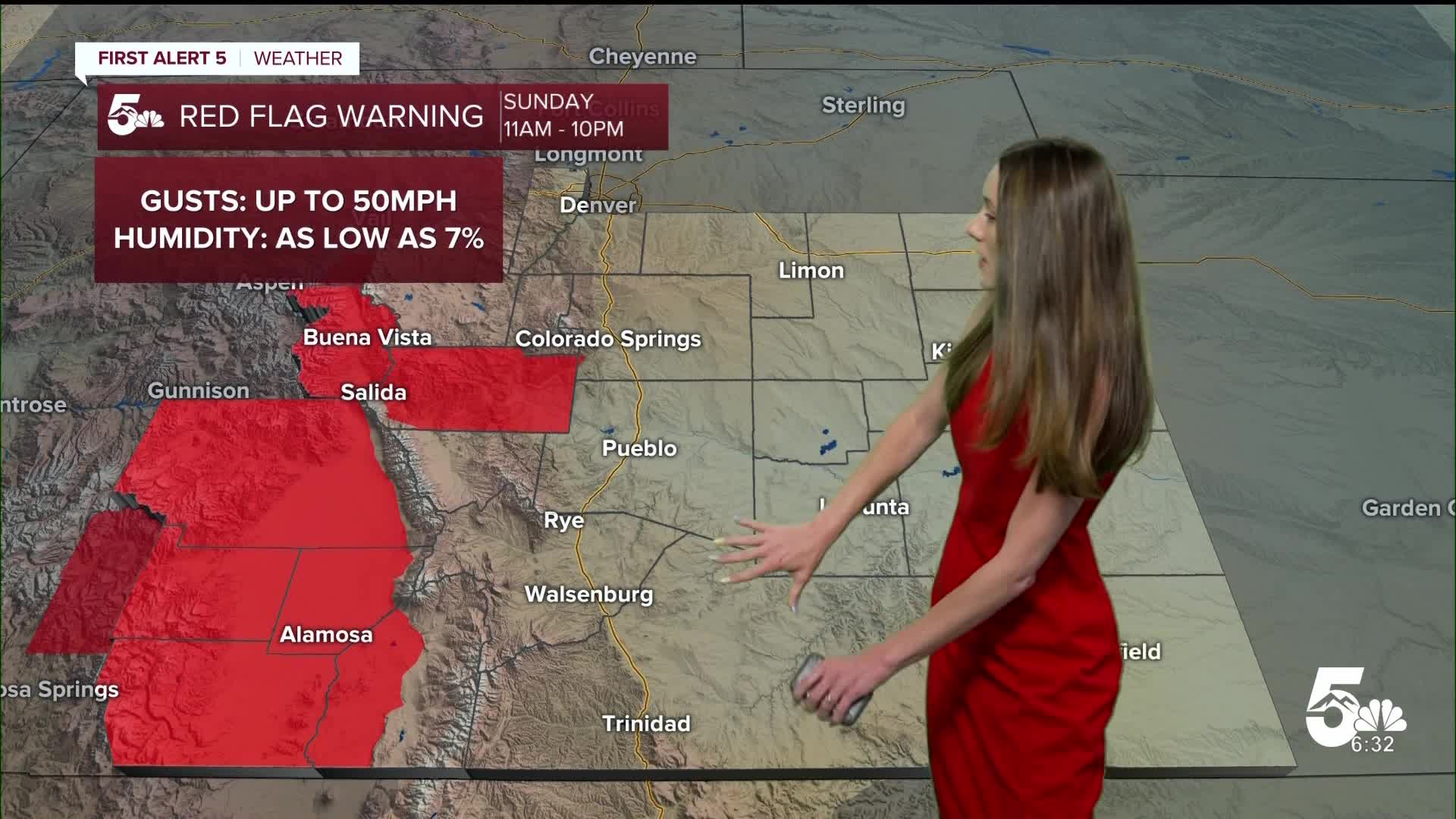
Canon City will have morning lows in the lower 60s. Be prepared for hot conditions and more fire danger in the forecast. Red flag warnings will be in place for Fremont county from 11AM until 10PM. Highs headed into the afternoon will be in the mid-90s. Evening temperatures will be slow to cool, so if you are spending some time outside it will be nice.
Woodland Park forecast: Low: 49; High: 79;
Woodland Park starts the day off with lows in the upper 40s. With clear conditions and plenty of sunshine, temperatures will eventually warm into the upper 70s by the afternoon. There will be some more clouds by the afternoon, but not expecting much in terms of rain.
Tri-Lakes forecast: Low: 53; High: 85;
Monument and the surrounding areas will have morning temperatures in the lower-50s. Clear conditions will start off the day along with some breezy conditions. Winds will be coming out of the south around 10-15mph. By the afternoon, highs will reach the mid-80s and there will be partly cloudy conditions. Temperatures will be in the 70s towards the evening hours.
Plains forecast: Low: 50s & 60s; High: 90s;
The eastern plains have another chance for some severe weather on Sunday afternoon. The Storm Prediction Center has parts of eastern Colorado in a slight risk (2/5) for the chance of severe weather. Large hail, damaging winds, and localized heavy rainfall is possible where we see these storms. Afternoon highs will be in the 90s.
Walsenburg and Trinidad forecast: Low: 58/56; High: 93/97;
The southern I-25 corridor will have overnight lows in the mid-50s. Temperatures warm up quick, and by the afternoon highs will reach the 90s. Luckily, there's not as much of a fire risk for Sunday. More clouds move in by the afternoon and hopefully will give some shade from the sun.
Mountains forecast: Low: 40s & 50s; High: 80s;
The mountains will have some breezy conditions in the morning and lows will be in the 40s and 50s. The higher terrain, though cooler than surrounding areas, will still have some warm temperatures. Afternoon highs will be in the 80s. Winds will be coming out of the west. These breezy conditions become a little bit stronger in the afternoon with gusts up to 30mph.
Extended outlook forecast:
The next 7 days still look active with the chance for some isolated storms each day. The best chance to get outside will be in the morning. Some storm activity will pick up around 2PM for Monday. Other days will be a touch later in the evening. The chance for rain will ramp up again on Thursday with another incoming shortwave. Lows look much cooler this week with Colorado Springs in the 80s, and Pueblo in the 80s and 90s.
____
Curious about the First Alert 5 Weather Storm Impact Scale? Check out our cheatsheet explainer.
Watch KOAA News5 on your time, anytime with our free streaming app available for your Roku, FireTV, AppleTV and Android TV. Just search KOAA News5, download and start watching.
