

Tonight's Forecast:
Temperatures will continue to dip back into the 20s and 30s across the area. No clouds in sight, but we will see that change going into tomorrow. Winds will also be much lighter compared to what they were earlier on today.
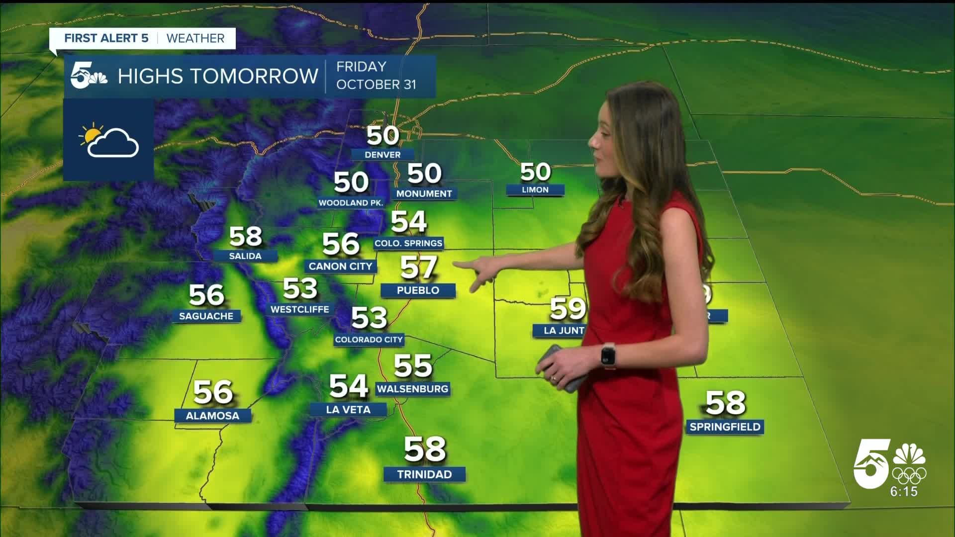
Colorado Springs forecast: Low: 30; High: 54;
Colorado Springs will have some mid-to-higher levels clouds in the area tomorrow. If you plan on getting out for some trick-or-treating tomorrow evening, temperatures will start out in the upper 40s. Once the sun sets, these temperatures will dip into the 30s. Those kiddos will want a jacket by that time.
Pueblo forecast: Low: 27; High: 57;
Pueblo will have highs in the upper 50s. This is slightly below average for this time of year, but we aren't having to deal with any snow. More clouds will move in and temperatures will eventually fall into the 40s by the time we get into the evening.
Canon City forecast: Low: 33; High: 56;
Canon City will have morning temperatures very close to freezing. Highs by the late afternoon will be in the mid-50s. More clouds will move in overnight and likely stick around. If you are going out for Halloween, expect temperatures to be in the 40s.
Woodland Park forecast: Low: 25; High: 50;
Woodland Park will be in the mid-20s tonight. Temperatures will warm up into the 50s. Any kids going out for trick-or-treating will want some layers under their costumes. There will be more clouds than the past few days.
Tri-Lakes forecast: Low: 30; High: 50;
Monument will start to see some lighter winds overnight and temperatures will be in the lower 30s. By the afternoon temperatures will rise into the lower 50s. Throughout the evening temperatures will be in the mid-40s and eventually fall into the 30s.
Plains forecast: Low: 20s; High: 50s;
The plains will be chilly overnight, dropping into the 20s. Winds will be between 5-15mph throughout the day. The highs by the afternoon will rise into the 50s. The evening will drop into the 40s.
Walsenburg and Trinidad forecast: Low: 29/31; High: 55/58;
The southern I-25 corridor will also have calmer winds overnight with morning lows in the upper 20s and lower 30s. By the afternoon these temperatures will rise into the mid-to-upper 50s. Temperatures will drop fast once the sun sets.
Mountains forecast: Low: 20s; High: 50s;
The mountains and higher terrain have a very small chance of seeing some sprinkles and flurries with this next system moving in, but most of the area will be dry. It will mainly just be clouds moving into the area. Highs will be in the 50s.
Extended outlook forecast:
The weekend looks very nice with above average temperatures. Not a whole lot of clouds cover either. Temperatures will stay pretty consistent with downsloping winds helping to heat things up.
____
Curious about the First Alert 5 Weather Storm Impact Scale? Check out our cheatsheet explainer.
Watch KOAA News5 on your time, anytime with our free streaming app available for your Roku, FireTV, AppleTV and Android TV. Just search KOAA News5, download and start watching.
