

Today’s Forecast:
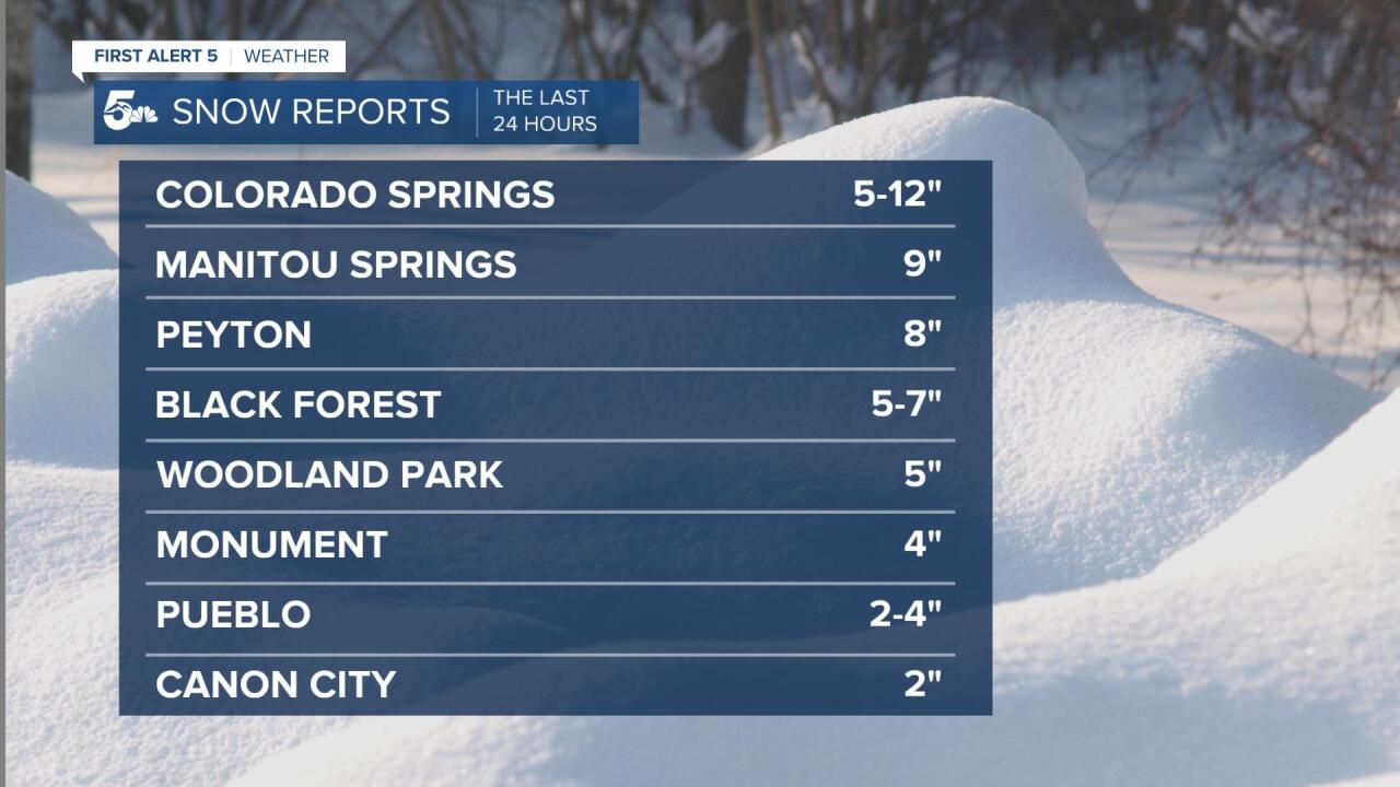
Snow last night hit southern Colorado hard, with Colorado Springs seeing a general range of 3 to 7 inches across town and around 2 inches through Pueblo. Temperatures are cold enough that untreated roads will stay covered in snow and even a little ice until we thaw later this afternoon.
The snow will stop pretty early this morning, with mostly dry skies in the plains by 9 to 10 am. We should crack some sun by the end of the day, but a cold night could mean a re-freeze for melting roads, especially in neighborhoods.
We will stay dry from this afternoon through Friday.
COLORADO SPRINGS: High: 31; Low: 18. Periods of light to moderate snow through the morning with improving driving conditions through the lunch hour as road crews plow the streets and the sun comes back. We'll be dry this afternoon but a chilly night could lead to a re-freeze on the sidewalks, parking lots, and in neighborhoods.
PUEBLO: High: 35; Low: 16. Light snow through the morning but dry and cold in the afternoon. The roads will be a little slick in the morning but we should be fine for most roadways in the afternoon. An icy night on sidewalks and parking lots is possible from a re-freeze as lows drop into the teens.
CANON CITY: High: 32; Low: 23. A mix of wet and snow-covered pavement through the morning with light snow ending early this morning. We'll be dry and chilly in the afternoon.
WOODLAND PARK: High: 29; Low: 14. Snowy and slow on the roads around town but especially west through Ute Pass. Driving conditions will improve through the lunch hour with dry afternoon conditions.
TRI-LAKES: High: 20s; Low: 10s. Slick and slow commutes through the morning from overnight snow with dry and cold conditions in the afternoon.
PLAINS: High: 40s; Low: 10s. Areas of heavy snow through the morning but most of the roads should remain drivable if you take it slow. We'll be dry in the afternoon and likely pop above freezing.
WALSENBURG/TRINIDAD: High: 30s; Low: 10s. Heavy snow from Walsenburg west to La Veta Pass early this morning with slick commutes along I-25 through Aguilar. We'll be dry and breezy in the afternoon with improving road conditions through the lunch hour.
MOUNTAINS: High: 30s; Low: 20s. Heavy snow through the early morning, especially in the southern Sangres near La Veta, Cuchara, and La Veta Pass. We'll be dry in the afternoon but the roads will stay snowy and slick until plows can make it over the passes and into the smaller routes.
Extended Outlook:
A few light snow showers are possible in the mountains on Saturday, but for our region, it only looks like a flurry at best would hit Teller County. We'll stay chilly through the weekend, but temperatures look to have a huge rebound early next week with 60s by next Wednesday!
KOAA News5 on your time, streaming on your Roku, FireTV, AppleTV and AndroidTV.
News5 App | First Alert 5 Weather App | Youtube | Facebook | Instagram | Twitter
