

Tonight's Forecast:
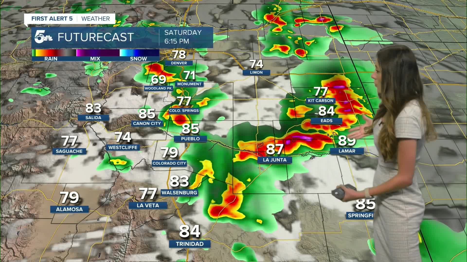
A severe thunderstorm watch will be in place until 9PM this evening. Teler, El Paso, and Pueblo counties are not included within this watch. The main risks with these storms will be 60-70mpg wind gusts, 1-2" hailstones, cloud to ground lightning, and localized flooding.
Overnight, there will be a few leftover showers, but most of the area will clear out. Sunday will have very similar temperatures, but conditions will be much drier.
Colorado Springs forecast: Low: 54; High: 86;
Colorado Springs will start to have storms clear out around 8PM. A few clouds will stay behind. Overnight lows will be in the mid-50s by the early morning hours on Sunday. Temperatures will be very similar to Saturday, but conditions will be drier. There is still a small chance for a shower or two to make its way off the mountains.
Pueblo forecast: Low: 57; High: 93;
Pueblo will have an isolated chance for some thunderstorms this evening. Temperatures will dip into the upper-50s overnight. Highs will be back in the 90s for Sunday. Conditions will continue to become drier. Triple digits will return Tuesday with no chance for rain.
Canon City forecast: Low: 59; High: 90;
Canon City will continue with warm conditions through the rest of the weekend and will continue rising by the time we get to Tuesday. Temperatures on Sunday will be in the lower 90s. Rain chances will continue to diminish, but there is still a small chance for an isolated shower to move into Fremont county tomorrow.
Woodland Park forecast: Low: 46; High: 78;
Woodland Park is not included within the severe thunderstorm watch, but there is still a possibility for some storms. These storms will calm down shortly after sunset. Overnight lows will be in the 40s and highs on Sunday will be in the upper 70s. Temperatures will continue to warm throughout the week into the 80s.
Tri-Lakes forecast: Low: 51; High: 81;
Monument will have a chance for some severe storms this evening, but things will calm down around 8PM as storms push eastward. A few spotty showers will be possible overnight, but by the morning things will clear out. Highs will be in the lower 80s on Sunday.
Plains forecast: Low: 50s & 60s; High: 80s & 90s;
The plains will have the best chances to see severe weather given the dynamics. The mains risks will be strong winds, hail, localized flooding, and an isolated tornado. We will have to continue to watch Kiowa, Bent, and Prowers county through the dinnertime hours. This will be the best time frame for tornado development. Overnight lows will be in the 50s and 60s and temperatures on Sunday will be in the 80s and 90s.
Walsenburg and Trinidad forecast: Low: 55; High: 90;
Las Animas county is included in the severe watch while Huerfano is not. This is set to expire at 9PM Saturday evening. Temperatures overnight will be in the mid-50s. Highs on Sunday will be in the 90s. Conditions will continue to clear out throughout the next couple of days.
Mountains forecast: Low: 40s & 50s; High: 80s;
The mountains will have a few spotty storms this afternoon, but things will quickly die down once the sun sets. Sunday will have a few spotty showers in the area. Highs will be in the 80s across the area.
Extended outlook forecast:
Conditions will stay consistent through Monday for most of the area. Once we get to Tuesday, everyone will notice a significant rise in temperatures. There are a couple opportunities to break records, especially in Colorado Springs. Limit your time outside and wear plenty of sunscreen throughout the week. Rain chances will remain below 10% throughout the week, except for the mountains.
____
Curious about the First Alert 5 Weather Storm Impact Scale? Check out our cheatsheet explainer.
Watch KOAA News5 on your time, anytime with our free streaming app available for your Roku, FireTV, AppleTV and Android TV. Just search KOAA News5, download and start watching.
