

Today’s Forecast:
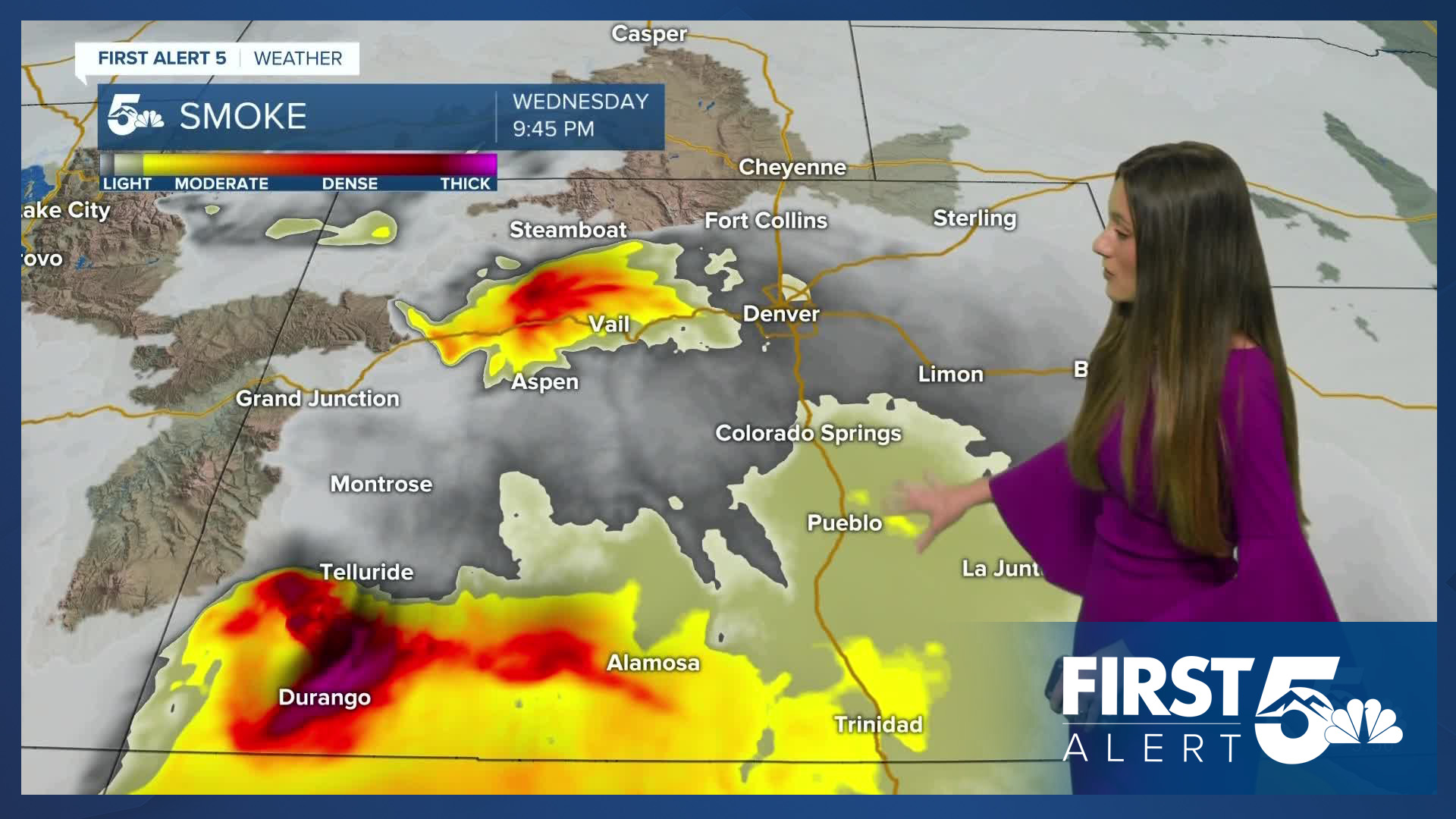
A dominant high-pressure system will raise those temperatures today. 90s are expected for most of the I-25 corridor. Higher elevations will still be feeling the heat with temperatures in the 80s by the afternoon. A spotty shower will be possible for the mountains but they will be short-lived. Smoke and haze will also continue across the area from ongoing wildfires out west.
Colorado Springs forecast: High: 92; Low: 61.
Colorado Springs will start the day with bright and sunny conditions. This will help to warm our temperatures quickly and by the afternoon we will be reaching the lower 90s. There will be some mid-level clouds that will move into the area later on in the afternoon.
Pueblo forecast: High: 97; Low: 61.
Pueblo will start this morning off with temperatures in the upper 50s around 6AM. Once the sun rises temperatures will warm fairly quickly. Afternoon highs will be in the lower 60s. Some smoke and haze will return to the area starting this morning.
Canon City forecast: High: 95; Low: 64.
Canon City will have temperatures this morning in the upper 50s. Lower 60s will arrive once the sun rises. By the afternoon, highs will reach the mid-90s. A fire weather watch will be in effect for Fremont county starting Thursday at noon. This is when the driest and warmest conditions are set to arrive and will increase the fire danger throughout the area.
Woodland Park forecast: High: 82; Low: 50.
Woodland Park will have chilly temperatures this morning in the upper 40s. It will be a warm afternoon with temperatures reaching the lower 80s. There will be an increase in mid-level clouds towards the afternoon as well from some leftover moisture.
Tri-Lakes forecast: High: 88; Low: 57.
Monument will start off with sunny skies and more clouds will build across the area later on this afternoon. Temperatures will climb into the upper 80s this afternoon. Overnight lows going into Thursday morning will be in the upper 50s.
Plains forecast: High: 90s; Low: 60s.
The plains will be hot and dry today. Sunny skies will help to warm temperatures up quickly this morning. By the afternoon, highs will have reached the 90s across the area. Winds will stay light throughout the day today.
Walsenburg and Trinidad forecast: High: 91/92; Low: 61.
The southern I-25 corridor will start the day with bright and sunny conditions. There will be an increase in smoke and haze across the area today. If you are sensitive to this it would be best to make sure any windows are closed throughout the day, and to limit your time outdoors.
Mountains forecast: High: 80s; Low: 50s.
Today, the mountains will have a few higher based and short lived showers. Temperatures will be in the 80s across the area.
The mountains will have a fire weather watch starting Thursday from noon to 10PM. This is when the driest conditions are expected.
Extended outlook forecast:
Looking ahead, temperatures will remain above average for the majority of us. More moisture will stream into the state this weekend and increase the rain chances. The best chance for rain will be on Saturday. Rain chances continue on Sunday, but it won't be as widespread.
____
Curious about the First Alert 5 Weather Storm Impact Scale? Check out our cheatsheet explainer.
Watch KOAA News5 on your time, anytime with our free streaming app available for your Roku, FireTV, AppleTV and Android TV. Just search KOAA News5, download and start watching.
