

Tonight's Forecast:
Clouds will continue to move out of the state and make way for clear skies. This will help to cool things down overnight and 20 degree temps will be in place for southern Colorado.
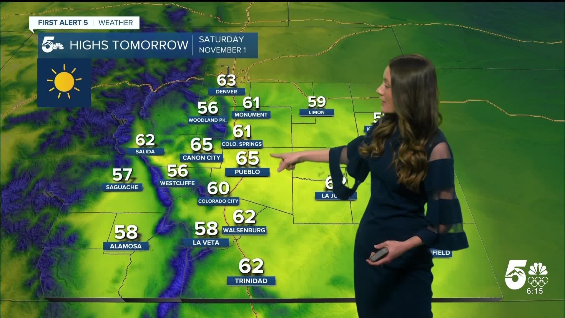
Colorado Springs forecast: Low: 25; High: 61;
Colorado Springs will stay clear tonight and temperatures will drop into the mid-20s. This isn't expected to last long though because by the time we get into the afternoon, temperatures will be in the lower 60s. Winds will be very calm tomorrow.
Pueblo forecast: Low: 23; High: 65;
Pueblo will dip into the lower 20s tonight. With plenty of sunshine to help to warm us up, afternoon highs will be in the mid-60s. This is above average for this time of year. There will be some roller coaster temperatures over the next few days.
Canon City forecast: Low: 30; High: 65;
Canon City will be calm with their conditions going into Saturday. It will be a nice day to get outside. Afternoon highs will reach the mid-60s.
Woodland Park forecast: Low: 24; High: 56;
Woodland Park will dip into the 20s overnight, and conditions will stay clear. With clear conditions cooling everything down this will also help temperatures to get into the 50s. It will be a chilly day overall, and a jacket will likely be needed if you head out.
Tri-Lakes forecast: Low: 23; High: 61;
Monument will be well below freezing tonight with temperatures in the lower 20s. Clear conditions will prevail across the area along with calm conditions. Heading into the afternoon, temperatures will be in the lower 60s.
Plains forecast: Low: 20s; High: 50s & 60s;
The plains will get cold tonight with temperatures in the 20s across the area. The feels-like temperatures will be even colder. By the mid-morning temperatures will be in the 40s and 50s. Temperatures will eventually reach the 50s and 60s.
Walsenburg and Trinidad forecast: Low: 25/26; High: 62;
The southern I-25 corridor will drop into the mid-20s overnight. Afternoon highs will be in the lower 60s. Winds will be on the lighter side throughout the day between 5 and 10mph.
Mountains forecast: Low: 20s; High: 50s;
The mountains will be below freezing tonight with 20s scattered throughout the area. There will be some clouds overnight, but these will clear in the morning. Highs will get into the 50s.
Extended outlook forecast:
Sunday will continue to warm up from a high-pressure system building over the four corners region. Highs will get back into the 70s and 80s. Some record breaking temperatures are possible. Going into Monday these temperatures will begin to cool, but will still be above average.
____
Curious about the First Alert 5 Weather Storm Impact Scale? Check out our cheatsheet explainer.
Watch KOAA News5 on your time, anytime with our free streaming app available for your Roku, FireTV, AppleTV and Android TV. Just search KOAA News5, download and start watching.
