

Tonight's Forecast:
Tonight, temperatures will be mild and close to normal. Overnight temperatures will get into the 30s and 40s for the lower elevations, and 30s for the higher elevations. Skies will be mostly clear and winds will stay light.
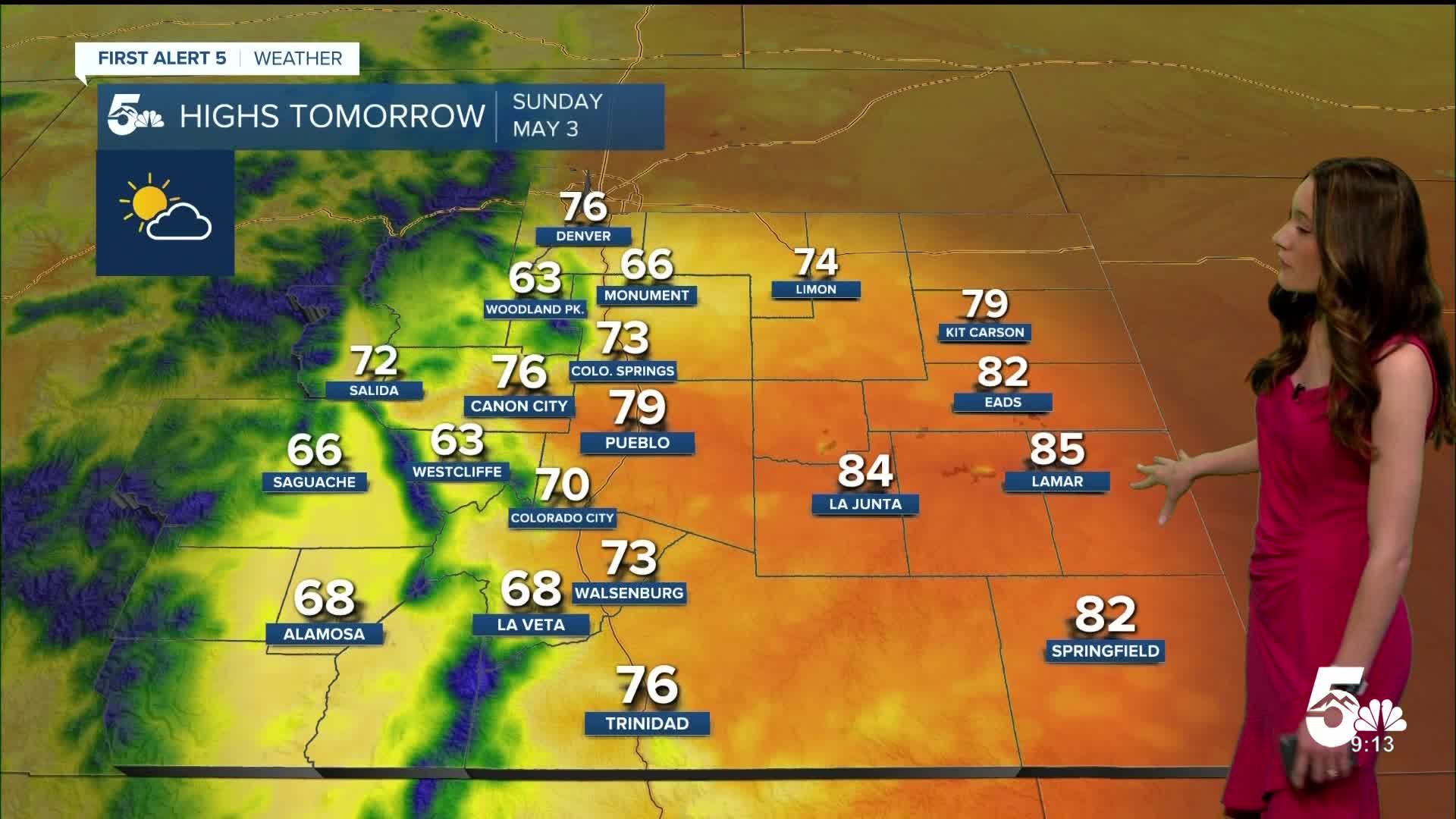
Colorado Springs forecast: Low: 41; High: 73;
Sunday morning, lows will reach the lower 40s. An upper-level ridge will bring warmer temperatures to Colorado Springs. Highs will get into the lower 70s, which is above average for this time of year. Skies will be mostly clear.
Pueblo forecast: Low: 40; High: 79;
Pueblo will wake up to temperatures in the lower 40s. Throughout the day there will be plenty of sunshine and conditions will be mostly clear. Afternoon highs will reach the upper 70s.
Canon City forecast: Low: 42; High: 76;
Canon City will continue with the mostly clear conditions overnight and lows will get into the lower 40s. Temperatures will be warmer than Saturday with highs getting into the mid-70s. Conditions will stay mostly clear during the day.
Woodland Park forecast: Low: 32; High: 63;
Woodland Park will be chilly Sunday morning with lows in the lower 30s. There is some energy over the mountains which will increase rain chances to around 10%. Most of the area will remain dry, but don't be surprised by a passing shower. Afternoon temperatures will get into the lower 60s.
Tri-Lakes forecast: Low: 40; High: 66;
Monument will have overnight temperatures reach the lower 40s. There is a small chance for an afternoon shower, and clouds will also increase in the afternoon. Highs will get into the mid-60s. Winds will be between 5 and 10mph coming out of the north.
Plains forecast: Low: 30s & 40s; High: 80s;
The eastern plains will have morning temperatures in the 30s and 40s. There will be mostly clear skies, and temperatures will eventually warm into the 80s.
Walsenburg and Trinidad forecast: Low: 41/38; High: 73/76;
The southern I-25 corridor will have overnight lows in the upper 30s and lower 40s. Winds will be coming out of the southwest between 5 and 15 mph. Afternoon highs will be in the lower to mid 70s.
Mountains forecast: Low: 30s; High: 60s;
The mountains will start the day off with lows in the 30s. There will be a chance for an isolated shower or two over the mountains. These chances will pick up in the afternoon. Highs will be in the 60s.
Extended outlook forecast:
Looking ahead, we have an active pattern towards the middle of the week. Rain chances will pick up Monday afternoon and this will last into Wednesday. As temperatures drop overnight, there will be a chance for this to mix over to snow. Highs will drop below average and some days highs will only get into the 40s.
____
Curious about the First Alert 5 Weather Storm Impact Scale? Check out our cheatsheet explainer.
Watch KOAA News5 on your time, anytime with our free streaming app available for your Roku, FireTV, AppleTV and Android TV. Just search KOAA News5, download and start watching.
