

Tonight's Forecast:
A blast of colder air moves in this evening and overnight lows will take a tumble. 20s are expected for the I-25 corridor. Luckily, winds will calm so the feels-like temperature won't be too far off from the air temperatures.
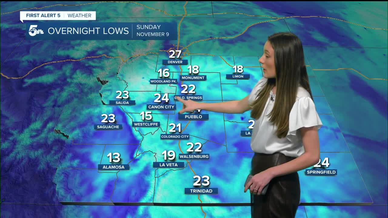
Colorado Springs forecast: Low: 22; High: 46;
Clear conditions to start off the day and most of the clouds that we see will be upper level clouds towards the afternoon. Still plenty of sunshine, but with a strong air mass sitting over the area, temperatures won't make it out of the 40s. Winds will be much lighter.
Pueblo forecast: Low: 24; High: 50;
Pueblo will have overnight lows in the mid-20s. Clear skies overnight will help temperatures to get chilly. Skies remain clear throughout the morning. Highs will be in the lower 50s by the afternoon. Winds will be coming out of the southeast around 5mph.
Canon City forecast: Low: 24; High: 49;
Canon City will get well below freezing, dipping down into the mid-20s. The morning will also be slow to warm, so don't skip out on the jacket. Afternoon highs will only reach the upper 40s. This is below average for this time of year. This will be very short lived because temperatures will jump back into the 60s by Monday.
Woodland Park forecast: Low: 16; High: 43;
Woodland Park will have some of the coldest overnight temperatures dropping down into the teens. Sunshine and afternoon heating will warm temperatures up into the lower 40s. Cold air will stick around throughout the day,so even though there is plenty of sunshine temperatures will still be below average.
Tri-Lakes forecast: Low: 18; High: 45;
The Monument area will see winds overnight between 5-15mph. They will be light throughout the day on Sunday. Morning temperatures will be in the teens and it will take a few hours for these temperatures to finally make it into the 40s. Highs will make it to the mid-40s.
Plains forecast: Low: 20s; High: 40s & 50s;
The plains will have some stronger wind gusts this evening, but will calm overnight. Morning lows will be in the 20s across the eastern plains. Highs will only make it into the 40s and 50s. The warmest temperatures will be along highway 50.
Walsenburg and Trinidad forecast: Low: 22/23; High: 48/50;
The southern I-25 corridor will have some stronger gusts this evening, but will calm overnight. Mostly clear skies will last throughout the day. Highs will be in the upper 40s and lower 50s.
Mountains forecast: Low: 20s; High: 50s;
Overnight, the mountains will dip into the 20s but higher elevations will be in the teens. It will be a chilly morning and highs later on in the day will be in the 50s. This will be very short lived and temperatures will warm going into the work week.
Extended outlook forecast:
An upper level ridge will bring back warm and dry conditions. This will last throughout the majority of the week. We are tracking a potential pattern change at the end of the week. There is still some uncertainty with the strength and timing of this incoming system. At they very least it looks to bring in some cooler temperatures and a little more moisture. Depending on how strong this system is and how far south it tracks it could bring some beneficial snow to the mountains. For I-25 there is still a lot of uncertainty.
____
Curious about the First Alert 5 Weather Storm Impact Scale? Check out our cheatsheet explainer.
Watch KOAA News5 on your time, anytime with our free streaming app available for your Roku, FireTV, AppleTV and Android TV. Just search KOAA News5, download and start watching.
